Good Tuesday, gang. A busy weather day is taking shape across the bluegrass state as heat and humidity give way to the threat for severe storms. The star of the show will end up being the big cool down that’s on the way later this week. The timing on that may deliver some of the best weather we’ve ever had on the 4th of July.
Lets breakdown what we are looking at in the short term…
TEMPS
– Highs today will range from the upper 80s to low 90s across most of the state. Humidity levels are crazy high and that will lead to a heat index around 100 degrees for many. Some areas may push 105 for a brief time.
STORMS
– While scattered storms will be possible at any point today, the bulk of the action comes late. A line of afternoon and evening storms may develop and drop across the state form northwest to southeast.
– Damaging winds are usually the biggest threats with this type of a setup. Large hail would be a much lower threat. Tornado threat is even much lower than that.
– Storms will be torrential rain and lightning producers.
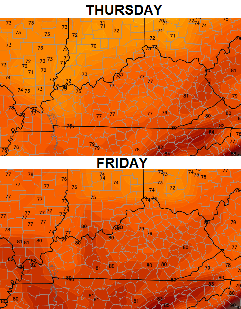
A cold front will continue to work into the region later Wednesday into Thursday. That means additional rounds of scattered storms should be around. The big news is what comes behind it. This is a healthy blast of cooler air moving in for the 4th of July Holiday period.
Check out the GFS forecast highs…
Now for the lows…
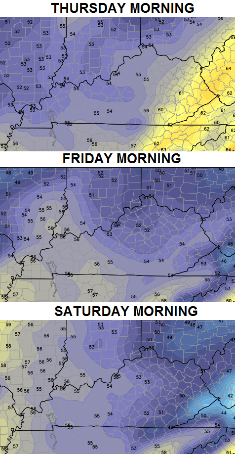 Like I said… this could end up being one amazing 4th of July! The only thing that could cause a change in that is the tropical development off the southeast coast. I will keep watch on that in the coming days.
I will also be watching today’s storm threat and you can do the same…


Today’s risk area

Current watches

Possible watch areas 


Current temperatures

Have a great day and take care.

Just don’t buy these 70’s models….I m betting the end of the week are mid to upper 80’s for most of Ky.
Thank you Chris for keeping us informed.
Thank you Chris for keeping us informed.
The temperature map on the KY Mesonet at 8:30AM looks like the forecasted highs for Thursday!
Thanks. I really love to bookmark these maps and track the storms. I guess I better bring my flags inside today!
What is with all this wind ALLthe time???
These clouds today will keep severe threat at a minimum, I would just love some good rains, Louisville area ended up 2 inches below normal for June, my area of frankfort didn’t fair much better!
Long range for July is saying below normal precip 🙁
Todd, I was thinking that to but the sun has been out in Louisville for the past few hours. Clouds are becoming less of a issue sun is pretty much dominating the sky’s in my neck of the woods.
Yep, sun has been out here for the last hour or so, this stuff might get going later, im at the believe it when I see it stage as far as a good rain in my area possibilities ??
Where did severe weather season go?
It stayed cold too long. I was looking forward to some good storms.
the radar at this moment is god awful.
my sprinkler here in Louisville is rested and ready to serve this evening.
Storm Prediction Center released their 1630 Zulu (11:30 AM Central/12:30 PM Eastern) update.
Most of Kentucky and the northwest part of Tennessee remain in the “Slight Risk” area for severe wx (thankfully, no raising to a “Moderate Risk”). Beforehand, the strong damaging wind and large hail threats were about the same, but now the SPC has increased the strong wind threat so that it is the threat with the highest risk. As Chris Bailey had already touched on in today’s post, a lower threat of large hail; still lower for an isolated twister.
+++++++++
Already a 75 degree dewpoint at Ft Knox. It’s 88 degrees with a 73 degree dewpoint in Nashville TN.
Looks like storms are beginning to fire a bit…in Ohio of course.
Dewpoints are in the 60’s in Central and Western Indiana so there’s a boundary somewhere. Y’all know how humid it is in Kentucky…
Okay, I’ll bite. How humid is it?
Severe Thunderstorm Watch now up for far western Kentucky and parts of adjacent states.
Some areas in Kentucky and Tennessee are now at or above 100 degrees on the heat index.
Heat Index was 104 here earlier
Thanks Chris. Looks like you may have a busy evening ahead. Thank you in advance for doing what you do to keep us all safe and informed. Stay safe everyone and have a great evening!
NWS downplaying the storms as they move into central and east KY, as always will shall see if they hold their strength as the get closer?
it would not surprise me if the storm line evaporates as soon as it hits the Jefferson County line.
Im with ya, the storms lately have just faded as they enter Louisville and frankfort areas!
Im not wanting severe weather but that sometimes is the only way to get decent rainfall!
I fully expect the line to totally collapse when it hits Jefferson County. It will then reform over Oldham County.
It does that in frankfort to, fades as it approaches only to refire the next county over?
I dont see that happening that line is solid and maintaining if not getting a little stronger. I think Louisville and Frankfort will get some much needed widespread beneficial rainfall.
Not ready to buy in just yet in frankfort, Louisville looks good at the moment!
as they should
starting to show signs of fade and split, frankfort area curse?
The cap may keep it from being as bad some mets expected and explained will some haven’t.
Ha, it completely fell apart as it hit Jefferson County. Not a drop of rain so far. This looked like a sure thing. The line is unbroken save for about a 20 mile stretch around Jefferson County.
Kelly come on you got hit by rain by now lol
but it is funny that a dry slot formed over Louisville.
but we should still receive some beneficial rain.
Just enough to wet the pavement. Still dry under the trees. Lots of wind and a few branches down but not much else. It’s starting to rain a bit now.
How bad will southeastern county be tonight? With the sun being down will that weaken the storms?
southeastern counties*
Nothing to worry about
Pouring here in Woodford County.
very light rain in east frankfort, thunder and lightning but very little rain, another under achiever in the latest run of storm threats!
So, you got no rain tonight?
maybe .10, if you don’t believe visit silver lake sub, and ask anyone how often the rains dodge this area!
I understand some parts of frankfort have got lots of rain, but not this area!
Also, do you have some sort of dire interest in need of consistent rainfall, or do you just feel the need to complain about something?
No Beth if makes you feel better, I’m just trying to figure out why this area is always on the short end of the rains every summer, I’m a weather fan and it seems very weird year after year of this happening??
A study might need to be done here!
And by the way, I’m close to 51 years old and do know a little about the weather 🙂
Stating facts isn’t complaining
You have said that for years, Eeyore.
Thanks andy, some people take reporting weather as a insult??
Yup just have to ignore the haters Todd
And I do live on a lake, so rain is nice to keep the level up and the fish alive!
And the disappointing Severe Weather Season continues….
BGA reported 0.37″ of rain within the last hour. No measurable rain here in my part of Lexington. Just enough to wet the pavement. I was seeing intense lightning in the distance for an hour and a half hoping for a good storm but the storms decided to evade my area. Lots of wind though!
Todd, I’m happy sometimes that we here in Nelson Co/Bardstown don’t get the storms (an April 3 ’74 “survivor” here-didn’t go thru it, watched it, it killed a relative..I don’t like bad storms..) We got a little shower a few min’s ago, looks like more coming….but I’ve noted how, whenever they call for a severe storm or tornado warning, seems like the storm “splits” just as it hits Nelson Co??! I think it’s the “knobs” cutting it off….?! What do I know??! lol 😉
I’m just here to read the comments. Todd just ignore Beth. Your blood pressure will thank you lol.
12:32 a.m. and almost 80 on the porch. Radar shows we might have a small chance here soon. Hopefully that will knock the temp. down a bit.