Good Tuesday, Everyone. Rounds of thunderstorms are working across the bluegrass state and could cause some issues. Strong and severe storms are a good possibility today as a cold front moves into the region. I have the blog set to track all the action.
Damaging winds and large hail will be the main threats from today’s storms. A smaller tornado threat will also be with us. Torrential rains could be enough to cause some local high water issues.
Much cooler air comes in behind the front for the second half of the week. Things looks very pleasant during this time.
Rounds of storms will develop over the weekend into Monday ahead of a HUGE dip in the jet stream. Check out this bad boy…
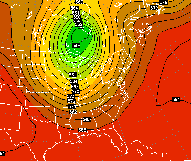 That is one impressive blast of cool air and could surpass what we had around the 4th of July.
Let’s track…


Today’s risk area

Current watches

Possible watch areas 

Hamburg Area from WKYT Studio
Lexington

I-75 @ Winchester Road Lexington

I-75 @ Iron Works Pike Lexington

I-75 @ Clays Ferry Bridge South Between Lexington and Richmond 
US 60 @ US 127 Frankfort

US 127 @ Frankfort Frankfort

I-75 at MP 36 London

I-71/I-75 at Buttermilk Pike Near Covington

I-64 @ 3rd St. Exit Louisville

Downtown Louisville @ 2nd & Broadway Louisville

I-65 @ 234 Near Bowling Green

I-24 MP 4 @ US 60 Paducah

Follow me on twitter for the latest updates on the severe threat.
Take care.

Thanks Chris. We could really use some rain but I hope it doesn’t get too severe. If that is what it takes to get some good rain thiugh I guess we well take it! Everyone have a great and safe Tuesday!
the rain that came through Louisville this morning. did not add up to much.
my yard needs a soaking.. I hope this is the day
Why do the storms and rain seem to be missing us here in south Lexington. They break up or go around us.
May fortune smile upon those in need of rain today. 🙂
Okay, who are you and what have you done with the real Hamlin?
I keed, I keed. Here, for your good mood today, you get a shot from last night’s Reds game.
http://i.imgur.com/GZ0tW2K.png
The real me is always a nice guy.
East Frankfort dry zone got 0.05 in. Of rain last night as I watched a storm about 4 miles north dump 2 inches of rain!
Just watched a shower fade as it got close this morning, the lake behind the house has really dropped lately, rain gods be nice today?
Todd,
Sounds like you live under a dome like us here in Berea. It is amazing to watch radar many times and see showers break apart as they near us. Some go north, some go south. Here’s hoping today will be different. The farmers sure need it.
Yes it’s frustrating, some folks in franklin county were under flood advisories last night but all I got was thunder and lightning and a brief shower!
Hoping today is different in areas that need rain vs the areas that don’t?
Yeah, last night looked prime here. The radar was showing some heavier storms nearing the county. They just died at the line. You could see it dying on the radar as it tried to push on in.
Thanks Chris, we sure need some rain. Fellow bloggers help me out here a little. I can see what the Kymesonet says for rain totals but I want to hear it from you so I can have an informed discussion with my students. I live in southern Montgomery and for the year have had only 19.5 inches of rain. Since May 1st only 5.65 that came in 2 storms near the 1st of May and near 1st of June. What about you guys? I am trying to build a rainfall map so if you could just tell me your county and rainfall since May and total it would help me out. Thank you
I don’t have a rain gauge to help here, but every so often Chris posts the detailed map that shows above/below normal rainfall for the past 30 days or some period of time. That would be handy in this case. I think it would also be colorful with some areas above normal (such as the CVG airport) and areas below normal (such as Todd’s yard).
Since May 1st about 8.5 in. In Franklin Co!
Much more than that in some places and most of that came in May in my area on the eastern side of County!
Wunderground.Com may help you
Thanks Folks. 10 minutes to my south in Powell County got some decent rain. But most of us got nothing.
Its been a weird spring/summer no real severe weather which is a good thing. We haven’t been dominated by the typical Bermuda High. Which in turn has been keeping the extreme heat off to our west. Cold fronts have been making this far south which is unusual this time of year usually they wash out or become stationary. Were in a wet pattern but it hasn’t been widespread with the rainfall some our getting plenty of rain others are not. 70’s for highs in July has happen already and might happen again next week as we go deeper into summer.
It’s gotten way crispy at my place. The rain has missed me for the last 2 weeks. Sure is frustrating to see the storms disappear over KY. Why does that happen? Seems to do the same thing in winter.
0.02″ here in my part of Valley Station. I’ve had less than 1.50″ since June 1.
The ‘cool down’ for next week with that dip in the jet stream may be related to the typhoon that just slammed Japan. I’ve heard it said, a few times now, that when a typhoon treks across Japan and moves northeast toward the Aleutians, within 7 days our weather will be impacted. How about that? A post-tropical cold front for our area.
I think the severe threat is hyped up.. unless things radically change over the next several hours, I just dont see it happening. (Reverse psychology)
NWS and some Louisville METS already down playing the storm chances for northern half of ky, best chances for big storms southern KY!
Most dry areas in Ncentral KY will stay dry the way it is looking!
Hope I’m wrong?
If southeast KY was under a snow dome back in the winter, then we here in northeast KY are under a big Pyrex dome and we’re getting cooked. The radar earlier looked as though we might get some rain, but the line of precip. just pulled apart and disappeared. Just spent 2 hours watering shrubs and flowers. Rain, rain, please rain today, or tomorrow.
If you dont get the rain today that will be it until Sunday or Monday
Wow – No rain today looks like for the northern half of ky 🙁
Strange pattern! The fronts that have been moving through sure haven’t been evenly distributing the rain.
Two distinct bands of clouds across Indiana. A thicker band near Bloomington is beginning to spark some showers. A thinner band north of Indianapolis is also trying to develop some showers. So, we still have a chance, but not a great one.
Looks like the energy is being focused to the north and East of Kentucky. :-/
The GFS just a couple days ago had most of KY getting 1-3 inches of rain this week, wow that model is struggling with overdone rain totals for several weeks now??
yeah that rain chart is about as credible as its snowfall chart.
A good rain for the Moberly and Waco area of Madison County a little while ago, but nothing in Irvine.
WOW, an 80 percent chance of rain for Ncentral KY this morning and we get nothing, sounds like a building drought feeding on itself!
I knew a wet summer wasn’t in the cards two years in a row!
Bright side, the mid to upper 90s have stayed away so far or things would be much worse!
We had a HEAVY rain go thru earlier lots of wind lightening thunder and some pea size hail. the wind took down all but 2 or 3 of our bean poles in the garden. We had a river running down our driveway then the storm moved out and then the SUN was shinning bright!!!!!
The lack of rain today has been very disrespectful
Huge bust in regards to rain. Even Chris is tweeting about it being dry in his neck if the woods. NWS really missed it today too.
I told the NWS Jackson folks on their facebook page “Ill believe it when I see it”