Good Friday, folks. Temps are getting ready to take a walk on the wild side of the thermometer over the next week and change. We are really going to toast things up this weekend before the bottom falls out as we head into next week. Another taste of early fall weather is on the way.
Highs today will reach the middle 80s across central and eastern Kentucky with some upper 80s in the west. Readings this weekend will surge to around 90 for highs with an increasing threat for showers and storms. The best chance this weekend looks to come on Sunday.
Storms should really increase by Monday as a powerful cold front pushes our way from the northwest. If we are going to get beneficial rains over the next week… this is our best chance. The GFS is showing us some love…
Stop teasing us, GFS!!
The showers and storms of Monday will be ahead of a monster dip in the jet stream for the middle and end of next week. This has been on our radar for more than a week, now.
Check out the summer version of the Polar Vortex…
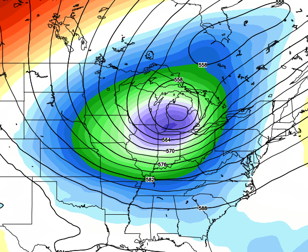
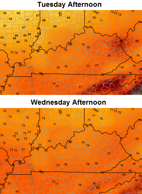
The Polar Vortex isn’t just a winter thing… it’s always there and is deciding to pay another visit to the same areas it spent a lot of time in this past winter. What does it mean for us? Check out the forecast highs…
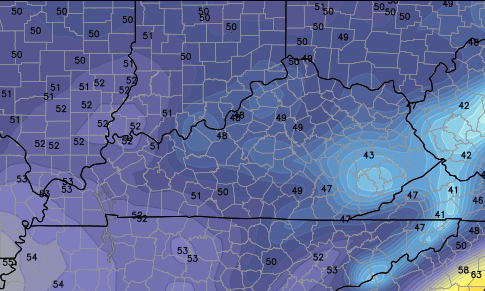
 And the lows by Wednesday morning…
Keep in mind… just a few days ago the GFS was telling its worshipers we would see 100 degrees during this same time period.
Have a great Friday and take care.

I trust the temperature map.
quietly confident that we will receive some beneficial rain.
Awesome, lovin these fall like cool shots..
My budget plan on my electric bill will take a dip too! Thanks Mother Nature!
Just bring some widespread good rains and the cool temps will be a bonus!
The good chance of rain is most welcome and the cool air behind it sounds great! I’m practicing my rain dance, just in case.
Im with ya, the GFS model has been writing checks that its been unable to cash lately, Im hoping for payday in the rain department!
Gives new meaning to a rain check LOL 🙂
I miss the days of real summer when we would have strings of days where it was 95-100 degrees and lows in the low 80s. and I also miss the Winters where it would be low 40s for highs except when we would have 10+inch snows and then the snow would melt 2 days later.
Ummm we do have summer’s like that happens quite frequently. Maybe not this summer but in general strings of 95 plus degree weather is quite common.
I like a couple days each summer when the high is 95-100 and upper 70’s for dewpoints are observed, but nothing more than that. That kind of extreme weather is hard on some folks, however…just like it’s hard on some folks (like me) when we get temperatures in the single digits or below zero or several inches of snow.