Good Saturday, folks. Hot temps are surging into the bluegrass state this weekend, but this heat won’t last very long. A big drop in temperatures is on the way for next week and it could put us withing striking distance of record lows.
When you go from hot to super cool… something has to give and that’s likely to be some pretty good thunderstorms later Sunday and Monday. The Storm Prediction Center has placed most of the region in the risk for severe weather during this time.
Between now and then… it’s hot, but nothing out of the ordinary. I’m fascinated by people who talk about how hot 90 degrees is in the middle of Summer. Normal highs are in the upper 80s for this time of year. Would these same people hype a 40 degree high temp day in December as being cold? Of course not, even if 40 is farther away from a normal high for December than 90 is right now.
Ok… rant over. 🙂
A few storms are possible today and regional radar will help you find them…

We have a better chance coming in late Sunday and Monday. This is when we get our powerhouse cold front swinging closer to the region. The European Model has this thing looking a lot like a wintertime clipper…
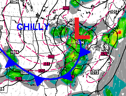 The air coming behind that will lead to a stretch of late September temps that will be well below normal. Check out the highs from the European Model…
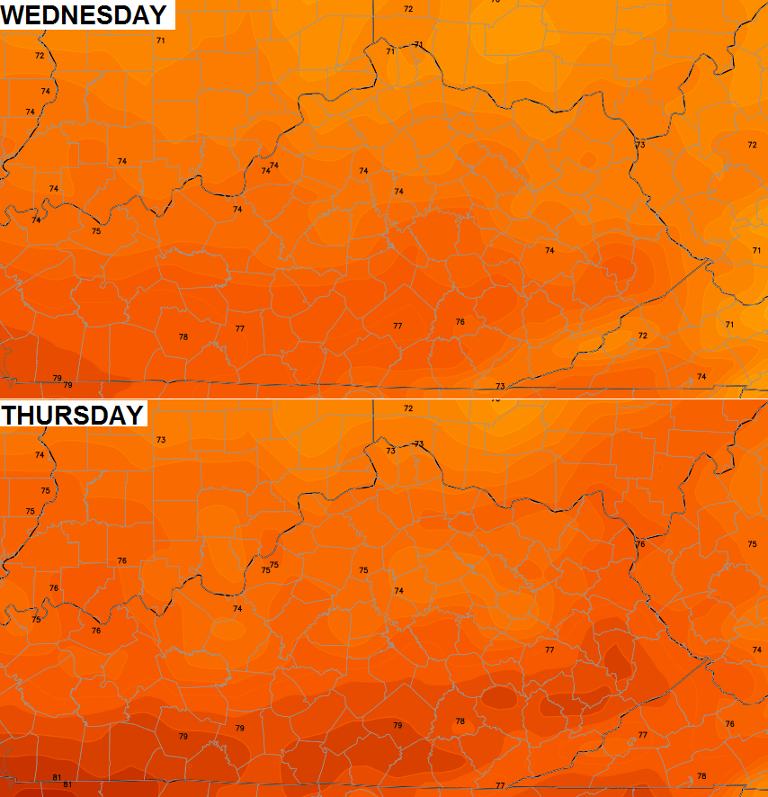 That is just crazy to see for this time of year. Lows on a few mornings may drop into the upper 40s to low 50s for many areas.
Enjoy your weekend and take care.

Thanks Chris. It looks like I may be able to wear long pants to work next week, at least for a day or two. I really don’t mind summer temps in the summer. It’s when we have 80 degree temps in February that I am not a fan of them. But I will also take a few days break from them as well. Not a fan of the possibility of severe storms but I don’t mind a good thunderstorm either. Hopefully we will get to see some good rain with this front. If it takes strong storms to get it, well, so be it! Gonna enjoy today just piddling around the house and doing a few little odd chores that I have been putting off. Have a great Saturday everyone and thanks again Chris for all you do!
Since there will actually be a temperature gradient and lift will be present in the atmosphere this time, I’ll play along with this one. Big storms are likely Sunday night into Monday.
I smell yet another slight risk
Yes, thank you Chris for always looking ahead for us. Don’t mind the ninety degree days of this summer so much…it’s just a little dry here in my neck of the woods. Certainly don’t blame anyone for that….this is the way things are and we deal with it. The cool air on the way will hopefully bring us some rain and I hope we don’t get it at the expense of severe storms. You will let us know, I’m sure. Thanks!
Actually I do know of one site that spent a lot of last winter hyping “cold” days that turned out to be highs in the 40s and 50s…
Oh yeah? Must have been some site way down south because we had our coldest winter in 20 years here in Kentucky. Enlighten me, please.
Even if it was a site down south, (which it probably wasn’t) the southern states were well below normal temp wise this past winter. The Florida panhandle had a Winter Storm Warning for freezing rain sleet and snow when was the last time that happen? No hype about the brutal cold this past winter in my opinion.
Sorry just now saw this. Was it really the coldest in 20 years? I’d like to know if that’s true. I realize it was colder than average but not sure how it stacked up. Do you base that on record lows? Low highs? Days below average?
This summer Polar Vortex will bring beautiful weather here, but chilly, sweater weather up north. Highs in the 50s in the northern states? Wow, and lows dipping into upper 30s too.
And all during the height of summer! Crazy….!!
Big complex of rain shrinking quickly in Indiana……I guess there was never any doubt.
I understand what Chris is saying but I’m not totally buying. I think 90 degrees is hot and just because the average high right now is 89, degrees, that doesn’t make 90 degrees any less hot. I guess what I’m trying to say is that our average summer temperatures are simply hot and describing average temperatures this time of year as hot is correct. Perhaps people should say that a 90 degree day is hot but seasonal.
In the deepest of winter, our average highs and lows simply aren’t very cold, not in the grand scheme of things, and anything above say 35 degrees should never be referred to as cold.
I hope that makes sense.
35 degrees and a stiff north wind is really cold. Down right miserable quite honestly.
You explained it well.
In Louisville, we will be flirting with record cold lows AND cold maximums during the middle of next week.
July 15 Forecast 77 (Cold Maximum – 74)
July 16 76 (Cold Maximum) – 75)
July 17 79 (Cold Maximum) – 76)
July 16 57 (Record Low – 55)
July 17 58 (Record Low – 56)
the fade and splitteroo has begun over Indiana.
I hope that 1 of these storm complexes makes it through Kentucky one time this summer.
That storm complex was forecast to fade away before getting into the commonwealth. Late tomorrow and Monday are our b est storm chances.
Thanks Chris. We can certainly use a good rain in Pulaski county. At least the central and southern parts of it. It’s funny how you can get in the car and see lawns dry and turning brown and go two or three miles where the showers have hot and see it a lot greener. We finally mowed yesterday , because the weeds grow whether it rains or not! ;). But it had not been mowed in over a week and won’t get mowed again until we get some rain. Here is hoping the entire state gets some good rains without having too much severe stuff! Have a great Sunday everyone!
I know I have been absent from this blog for awhile. I’m a wedding coordinator and deal with a lot of outdoor weddings. Chris, I still rely on this blog to find out if we have a wedding outdoors, or if we need to use a Plan B. July is always just “hot”. However, let’s remember July 4th and I think the upcoming week is going to be a glorious diversion. I love these little “hints” to fall that we get. And…..we do need rain!!!!!! Hello to all my old friends. I’m still here – just not a lot of time to chat…..I read you all the time though.