Good Tuesday and welcome to a taste of fall. A much cooler than normal pattern is settling into the bluegrass state and could lead to record low temps in the coming days. This air will hang tough into the start of the weekend. That’s when it may be joined by another decent shot of rain.
A cold front is blasting out of southeastern Kentucky today and is taking the showers and storms with it. Cool and dry air comes in behind this with highs in the middle 70s across many areas. The south and southeast could be warmer depending on the timing of the front.

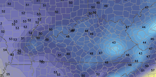
Current temperatures

Tonight’s temps will drop like a rock with dry air and mainly clear skies. The GFS is rocking some almost chilly temps by Wednesday morning…
That would certainly leave a mark on history. Those are likely too low, but upper 40s to low 50s look very possible in many areas and records may fall.
Highs Wednesday and Thursday should stay in the mid and upper 70s with some sun. Friday will see a moisture rich system making a run at us. The Canadian Model shows a healthy rainfall…
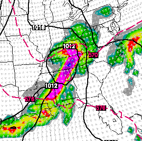
The European Model isn’t to different and holds the rain into Saturday…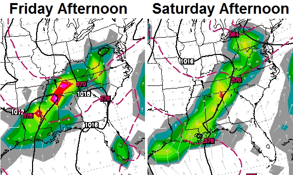
Friday has the potential to be a very cool day if the rain arrives early enough. The highs from the European Model are ridiculous…
 There is a lot of 2009 to this pattern!
Enjoy your day and take care.

I like it.
Thankful for the rain received yesterday.Still raining lightly at 1:45 AM this morning.Very quiet and peaceful.
So, um, about that front coming through “over the evening and overnight hours” (radio spot)…did something happen to the front? The same radio spot had CB saying we’d have “lows in the upper 50s and low 60s” last night. Radio spots for WKYT only discuss that night’s lows and the highs for the next day. I guess I must have hallucinated hearing those radio spots due to sleep deprivation.
6AM and our low was 68 to 70 for Madison County, and it looks like almost everyone in the area was 66 to 70. Dew points are still in the mid and upper 60s, which is still about where they were yesterday at this same time and all day.
Anyone who is in the know weather-wise care to put a specific time on when the cooler weather is actually suppose to arrive for Madison, Fayette and surrounding counties?
Well, if you look at the national satellite, I’m guessing those clouds that are above us push through and the dry cool air filters in and then tonight will get cooler than normal.
I was one of the very unlucky spots. Not very much rain here at all..
Same here, so far only recorded ~0.4″ of rain in my part of Lexington.
Same at dry old east frankfort, while many areas got 1 inch plus rains my yard got .30?
Less that 1 in. In the last 30 days!
same here in Valley Station, just outside of Louisville
i have a hunch that winter will be in here sooner then we want it to be so just be pre-paired for it this winter cause most of us wasn’t lol 2009 o no that ice storm i went a 16 days with out electric had to cook off a kerosene heater lol
I am surprised I was able to go back and look this up. July 2009 at the CVG Airport…the average temperature for the month was 70.1, a departure of 6.2 degrees below normal. There were 15 days where the high temperature failed to reach 80. Two days the high temp was 70 and on July 1st, 2009 we had a high of a balmy 69 degrees. The highest temperature observed the entire month was 85.
On the precip side it was a fairly wet month with 5.35″ of rain.
Another thing I know Chris will be keeping his eye on…the following winter, the CVG Airport observed 26.1″ of snow the following February alone. I think the ‘Dome’ was in effect down in Kentucky at that time if I recall.
It’s pouring the rain here in Pikeville. We didn’t get any big storms or any surplus of rainfall yesterday but we got quite the lightning show.
Took a midday walk. It’s like looking at everything in High-Definition, so crisp and clear.
I don’t recall anyone crying out ‘Polar Vortex’ on July 28, 2013 when high and low temps were 77 and 56 respectively for Louisville. Weather map almost looks similar to this year’s map. This polar vortex thing is so overdone….
http://www.wpc.ncep.noaa.gov/dailywxmap/index_20130728.html
I can’t believe after all the storms on the radar for the month we’re at .55″ for the month at my house :/
I might have to bust out my hoodie tonight. Cool crisp September feel in the air in the middle of the dog days of summer. Yeah buddy!!! Feels and smells like football weather.
Temps area great, the rain department sucks, it just seems impossible to get a widespread cluster of storms to move through KY, Tennessee , Ohio, Indiana, Illinois, West Virginia all have had widespread rains the last view weeks, if I didn’t know better i would think mother nature thinks this is snow systems??
3.6 inches of rain on my gauge here in Leslie County, within last 36 hours