Good Wednesday, all. The blast of fall air looks to dominate our weather for the rest of the week. This is about as cool as the temps can get in the middle of Summer. Sure, we may have had cooler “days”, but it’s rare to get this for several days in a row.
Record lows could fall to start out today with several locations dipping into the upper 40s to low 50s. Kentucky Mesonet gives you a glimpse of some of the lows from across the state…
Today’s Lows

Current Temperatures

Highs this afternoon will range from the low to mid 70s for many areas with a mix of sun and clouds. With such cold air aloft, a stray shower or two may develop during the heart of the afternoon.
Thursday morning will be another chilly one with low and mid 50s. Some of the record lows tomorrow are a bit warmer than this morning’s, so we could be within striking distance. Highs Thursday will be in the mid and upper 70s.
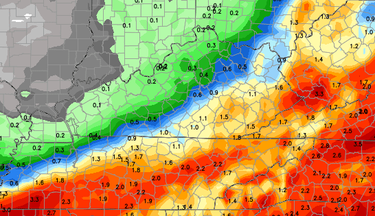
Our next threat for rain moves in Friday into Saturday. The European Model has the heaviest falling across the eastern half of the state…
If you’re more of a fan of our neighbor to the north… the Canadian Model is farther west with the heavy rain…
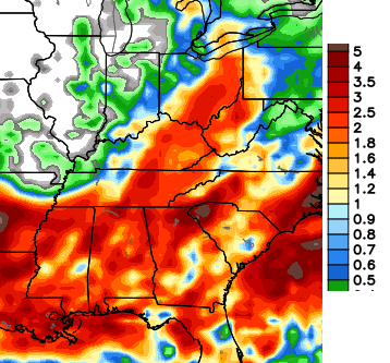 Go Canada! 🙂
Temps will remain below normal through the weekend.
Make it a great Wednesday and take care.

Thanks Chris. I imagine that hese are the kind of days you LIKE to write about!
Weather can be SO FRUSTRATING :/
I’ve been following this page for little over a year now every morning i get on and check it out lol ty chris for your hard work and dedication you put in for some of us weather bugs lol anyways: this is odd for it to be this cool i had to turn my a/c off it was freezing up so i opened the window stuck a fan in and boom saved mula and stayed cool lol im curious to see what august will bring we normally tend to be warmer and really dry in august hope the cool weather stays around…will help out alot with the folks that work out in the sun and in them hot factorys…but ya have good day
Because of the cooler air, working in the yard last evening seemed much easier. Love these cooler temps. What a nice break! Rain for this weekend doesn’t sound too bad especially if some areas finally get what they need. Thanks, Chris, for always looking ahead for us.
It was 53 degrees in my backyard this morning (5 miles N of Pikeville)
GFS shows a huge ridge of hot air building back in next week. Not sure if that will lead to us being in the “ring of fire” or not. As of now, there is no NE temperature boundary visible on the data.
Thanks Chris. We got a pretty good shower yesterday morning again here and wound up with a total of 3.65 inches of rain at my house. not complaining. Hope we can get more on Saturday. I do like the cooler temps, especially on my electric bill! Opened the windows and turned on the ceiling fans last night and stayed very comfortable in the house! I like that kind of stuff! Hope everyone has a great Wednesday. Thanks Chris for always keeping us informed!
Wonderfully,cool day here.Not sure how much rain we got because my rain gauge froze during the winter and cracked but we got a good bit.The ground is still wet so I am waiting awhile to do some yard work.For now the thermometers are hoovering between 68 and 70.
Just a few peeks of sunshine off and on all morning.Still looks very overcast mostly but occasionally it gets bright.I suspect it will become much more sunny this afternoon.But its COOL.Loving it.
I hope the really hot air doesn’t come back but its summer so it likely will return soon.I always look forward to Fall though.Already trying to start my winter plans since if it snows an inch and stays cold I can’t get off this hill for a week or longer.
I guess the 50 percent chance of rain this weekend means 10 percent for my yard, can’t buy a good rain in these parts !
Todd, I feel your pain. We haven’t gotten much rain either (northern Jessamine). We got about .5″ out of all the rain chances when others got 3″ or more.
I commented briefly about the polar vortex thing being overdone. When I looked at July 2013’s weather, the last 8 days of the month, many locations including here in Kentucky underwent significantly below normal readings for that time period. More than 900 record low temperatures were set during that time, perhaps peaking on July 28, when more than two dozen locations set record lows for the entire month of July.
Looking at daily weather maps, high pressure of 1028-1030mb was building in from Canada and keeping several locations within its northwest flow.
Yet, no mention of a Polar Vortex even though last year’s extended cool down seems more pronounced than this one. Perhaps, the core of the coolest air remained a tad farther north than this one but I believe the term Polar Vortex is quite overused, especially in summer, but it does just sounds sexy, don’t it?
http://www.ncdc.noaa.gov/sotc/national/2013/07#MRCC
http://www.nws.noaa.gov/view/national.php?prod=RER
The “average” temp for Lexington today was 66. That is normal for either May 21 or September 21. The normal average today is 76.