Good Friday, everyone. Rain will be increasing across much of the region today and that’s a trend that carries us into the weekend. The heaviest rains look to fall across central and eastern parts of the state with lighter amounts in the west and far north.
Here’s a quick breakdown…
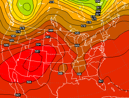
– This is almost like something we would track in the winter months with a sharp western cutoff to the precipitation shield.
– Showers increase today from southwest to northeast. This is not a washout anywhere, but some showers will be around.
– Temps today will be warmer in the west and north and MUCH cooler for areas getting in on clouds and showers. As a matter of fact… readings may drop into the 60s as the drops fall.
– A greater slug of moisture rolls in tonight into Saturday. That’s when we will likely see the sharp gradient in the heaviest rains setting up. The best bet for heavy rain is across the south and southeast.
Track away…

Current temperatures

Scattered showers and storms will be around into the weekend as temps slowly warm. The overall pattern into next week is much warmer and more humid with a daily threat for showers and storms. That threat may be elevated because of a weakness in the atmosphere showing up right over our region…
That pattern looks to be replaced by another deep trough digging into the eastern half of the country sometime nest weekend…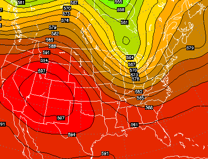
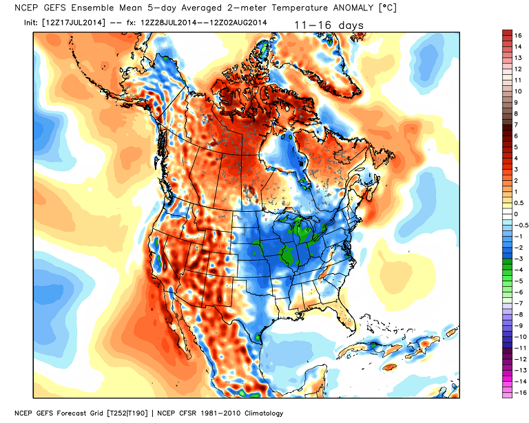
The GFS Ensembles have a fairly strong signal for another shot of well below normal temps as we close out July and move into early August…
 I can live with that!
Make it a great Friday and take care.

The official reporting gauge for Lexington has only recorded 0.87 inches of rain for July so far. July is on average, the 2nd wettest month of the year in Lexington, only trailing May. I do hope we get some rain, because the three driest months of the year on average (August, September, and October) come next.
We have missed an extraordinary amount of the rain chances for awhile now. Maybe we can catch up this weekend.
Must be cloudy over most of Central and Eastern Kentucky at this noon hour if temps are in the upper 60’s while up here in Ohio we are enjoying low-mid 70’s and sunshine.
Very overcast here.Thermometers have only made it to 65.
Rained a small amount early this morning and the sun hasn’t come out at all.
Glad to see we may have another shot of cool coming up.A bit dreary but loving the cool temps.
Edit: skies are now overcast up here as well.
probably going to be a dry out weekend for Louisville.
going to the outdoor concerts at the river.
so I will see plenty of water.
rock and roll all night long.
low to mid 60’s with some rain and thick cloud cover for eastern parts of Kentucky…could be stuck there.
CB’s been talking about 2009 recently. I read a quote from the Memphis NWS page…
THIS MAY BE THE COLDEST DAY IN THE MID-SOUTH SINCE RECORDS HAVE
BEEN RECORDED. TODAY/S FORECAST HAS TEMPERATURES REACHING INTO
THE MID 70S IF THIS HOLDS THEN MANY AREAS WILL HAVE THERE COLDEST
MAXIMUM TEMPERATURES FOR JULY 18.
MOST OF THE VOLUNTEER COOPERATIVE STATIONS HAVE COLDEST MAXIMUM
TEMPETURES AROUND 80 DEGREES FOR TODAY…MANY OF THESE RECORDS
WERE SET BACK IN 2009.
Four climate stations have a real chance at setting coldest maximum temperatures for today: Memphis, Jackson, Jonesboro AR, and Tupelo MS. Three of the four are still in the mid 60’s at this hour, while the other is only in the low 70’s. And that’s Jonesboro, whose coldest max for this date is 81.
Thanks Chris. WE would likely love this pattern if it were winter time here in the southern parts. But we would likely still see rain out of it instead of snow 😉 As for the below normal temps, I have enjoyed the cooler temps for a couple of days, but it is still summer, and I am not ready for the warm temps to go. We seem to be getting our seasons
really out of whack! I don’t mind a respite, but I think that describes it.. a respite, instead of the norm. I love my sunshine and warm temps. Hope everyone has a safe and Happy Friday!
By the way, meant to say in my last comment that we have had nearly steady showers for a big part of the day. Had a little clearing a
couple of hours ago, but now it is overcast and wet again. This is a good rain though, as it is falling slowly and soaking in. We have really needed that here. (Still don’t want record cool temps in August though! ;))
Basically the same here all day.Seemed a bit surreal only seeing 65 or so for the high on my thermometers today.It started back raining shortly after I made my earlier post and has continued all afternoon.Just slow,soothing rain.Have the kitchen windows up and it sounds so peaceful and refreshing.
Feeling good that I can enjoy the rain without the storms with it.The sun didn’t come out at all here today.
I have enjoyed the coolness but I am not quiet ready for Fall yet.But it is nice to get a couple days of breaks from the heat.I can wait awhile for winter.Still have a lot to get done before that comes.
But sounds like Chris is saying we will have a warm up and then another good shot at cool for a couple of days after that.I can live with that.
Very light rain falling in parched east frankfort, some rain is better than none, crazy cool out 64 degrees in mid July??
Fairbanks AK 68 degrees last hour
Sunrise 4:03am; Sunset 11:49pm
Jackson KY 66
Louisville KY 67
Lexington KY 65
Bowling Green KY 67
London KY 65
Somerset KY 64
Nashville TN 68
Fayetteville AR 63
Starkville MS 68
Thanks, Mike!
Nashville only got up to 69 today, so odd for July (currently 66). Great on the cooling bill. Not-so-good for outdoor swimming 🙁 .
Like many other areas today, Nashville has been solid overcast with some periods of light rain.
This reminds me of one of those dreary, grey, slow rainy days we get in the middle of winter.
I have said I have not had much rain at my place for a while. Well, today is much different. Radar may not show much but it has been fairly steady at my place since about 3 p.m. or so. Temperatures are very cool as well.
this is a drought buster for a lot, a STEADY/SLOW rain seeps into the hard ground..
Yes for sure.It is cool but I am thankful to see this type of slow and steady rain coming down for a few hours.No storm to worry about and not as much risk of any flooding when its like this.We certainly needed it in this area.My yard was sounding crunchy when I walked on it.Of course that means I will have to mow soon but I will gladly do that compared to being in a drought.
Love this Global Warming, LOVE IT!
You really need a reality check.