Good Sunday, everyone. The past week has been among the coolest you will ever find for the month of July across the bluegrass state. It’s pretty amazing the lack of attention it has gotten from many in the weather community in this region. Well… these folks will be happy for a few days. Why? We have a quick hitting blast of normal summertime heat to hype! 😉
Many areas should FINALLY crack the 80 degree mark today as scattered showers and thunderstorms goes up. The best chance will be across central and eastern Kentucky…

Current temperatures

Temps will take off over the next few days with highs in the upper 80s to low 90s across the state. This isn’t too dissimilar to what we had a week ago ahead of a cold front. The difference this time is the ground is MUCH wetter across the area. Central and eastern parts of the state picked up anywhere from 1″ to 5″ of rain during this time. Not bad!
A scattering of showers and storms will be around each afternoon through Tuesday. A cold front will cause showers and storms to increase late Wednesday into early Thursday. That could drop some pretty good rains on the region and will introduce another cooler than normal pattern…
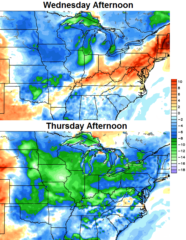 That should give us highs from the upper 70s to low 80s for Thursday into Friday with partly sunny skies. Readings will spike up on Saturday ahead of another cold front diving toward the state. This should touch off additional showers and thunderstorms and is being pushed by a much deeper dip in the jet stream…
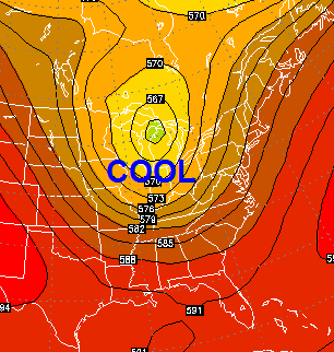
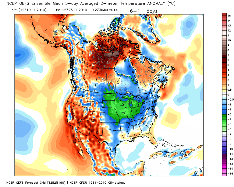
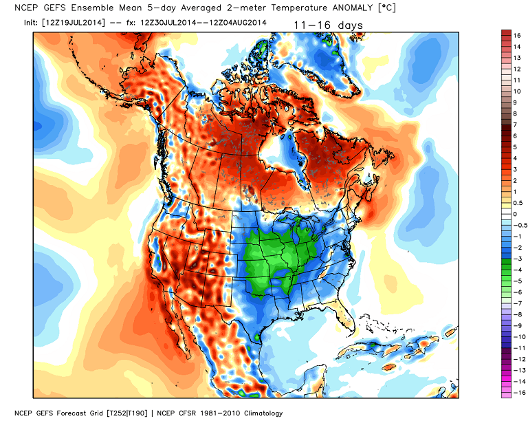
That trough in the east is something that looks to hang tough into early August…
 The end result would be a continuation of the cooler than normal pattern…
 Make it a great Sunday and take care.

“It’s pretty amazing the lack of attention it has gotten from many in the weather community in this region”
I cannot help but wonder if this is due to their stance on “global warming”
?
Its as simple as this, if people believe in Global Warming, they aren’t going to talk about any phenomenon that could lead anyone to doubt the credibility of global warming. but you can bet that if it was pushing 110 degrees for 2 weeks in a row, they wouldn’t be able to type up blog comments fast enough ecstatically saying here is the proof.
I don’t really believe in global warming. Earth goes through periods of warmer and cooler temperatures. Ice ages happen and guess what? It will get warm and the ice will melt. Earth has been doing that since it was created.
You are 100 percent correct. Weather runs in long cycles of 20 to 30 years. We have entered a mini ice age and this is how it is going to be for the foreseeable future. Winters will be colder and our summers not as hot. Go Cards bring on the ACC!
I have always wondered why these scientist rarly speak of the glaciers that were as far south as Tennessee thousands of years ago? man didn’t melt them, man was not here then, the earth melted them because it got warm on its own!
Be careful! The GW Police might find you! You know, the ones who claim it is “science”, yet do not listen to other points of view and data results and say it can not be argued since fact.
Follow the money! 😉
No they just say its “settled science” and be done with it like that phrase alone some how carries with it the ultimate in science credibility and then call you a denier if you dare challenge them.
Interesting… would that be the same people who point to a cold winter and say there is NO global warming? And who ignore the warmest AVERAGE temps since records have been kept? Or who don’t know how to read a graph? Or who ignore the scientific consensus of ~99% of the world’s climate specialists in favor of the one who is paid by the oil companies? Those people?
Thank you, I thought I woke up on a Faux News site! You said it perfectly!
did you read what the ex vice president of Mobil Oil had to say on the subject?
basically he claims that the fossil fuel industry has already started budgeting climate change in their forecast.
also is NASA the Pentagon and private insurance industry part of this conspiracy to cook up faulty data.
Thank you for being a voice of reason. You see it everywhere…spring comes weeks earlier, fall comes weeks later, winters are warmer and wetter (Eastern North America was the exception to the REST of the planet this past winter) and summers are much warmer. If you are 29 years or younger, you have never experienced a month where the global average temperature was below normal. Not once.
I’m all for being critical and skeptical but the science of global warming/climate change is settled and has been for years. It is happening and we are causing it. 2014 is on track to be the hottest year ever, until 2015 of course.
http://www.popsci.com/article/science/2014-will-it-be-hottest-year-ever
Sounds like just a bunch of hot air LOL!
Just having fun 😉
There is no such thing as settled science, “settled science” is the phrase of pseudoscientists use to attempt to discredit others attempting to show valid scientific data suggesting the opposite of their agenda
Tinfoil hats are on sale at Wal-Mart.
No thanks, those are for the settled science believers.
As cool or cold as it may have been here in January (considering it was winter) the global temperature was fourth warmest since records began in 1880.
February was only the 21st highest on record for global land and ocean surface temperatures.
Global land and ocean surface temperatures where the fifth highest, on record, in March.
Global land and ocean surface temperatures average in April where tied with 2010 as the warmest on record.
May of 2014 saw the highest global land and ocean temperature average on record.
It is important to note how much of an impact the oceans have on temperature. Water makes up a huge portion of our surface. The impact of overall warmer oceans will have a much larger impact on global climate and thus global temperatures.
As far as I know, nearly every met forecasts a cold winter every winter. When was the last time CB forecasted a warm winter? Every met I follow (about 8 or so) and ones I don’t follow predict cold winters every winter.
And about the whole GW, we all know that the world has been warming since the beginning of modern weather measurements. It has slowed down and nearly stopped. What gets everyone is the fact of whether it’s human induced or not. We do not have enough evidence to confirm that GW is man-made or natural at this point. I personally believe that humans play a role in GW but it’s a mix of earth’s natural cycle and humans. Just keep in mind that The absence of evidence is NOT the evidence of absence. And that goes for both sides.
In the western US, they’re having record heat. Where there’s a trough, there’s a ridge. Also, consider: weather is not climate, and your backyard is not the globe.
I think the biggest stumbling block for us non-scientists when we talk about climate is that it doesn’t happen on a scale we can perceive. I can perceive that today or this week or even this month was cool/normal/hot, but I can’t say anything like that once you scale up to years, decades and centuries. And that’s the scale on which climate occurs.
It seems we are still in the same pattern we came out of winter. How could that be? Just seems the weather patterns are longer term for some odd reason. I like cool but in the fall. I like some hot days in summer but sure doesn’t seem like we’ve had any. Oh well, mother nature always wins.
With weather like we are having right now we all win! Unless you like 90 degree heat with high humidity. I stated back in March that this pattern would stick around for the summer and really put a damper on the pool season. Pool has been open since just after Derby and my family has only swam a few times due to cool water temp. This winter will be worse than last!!!
Well. I don’t really understand why climate change or global warming is such a contested situation. Why is it so important to believe it isn’t happening? Anyway. Here is a link from the conservative leaning Washington Post. It is quite relevant to the myriad conversations on this blog.
http://www.washingtonpost.com/blogs/wonkblog/wp/2014/01/06/can-global-warming-be-real-if-its-cold-in-the-u-s-um-yes/
Maybe because people and businesses are sick and tired of being taxed, regulated, and mandated out of their wealth just so pseudoscientists like Al Gore and the rest of his environmental cultists can carry on and on about how mankind in the last 50 years alone have destroyed what hundreds of detonated Nuclear Warheads couldn’t have done just by driving a gasoline powered car or by burning coal a naturally present fuel source in the Earth.
Well the high dewpoints are back very humid and sticky outside
Parts of Lexington getting nice rain at the moment, wish their was more to go around!
Not a drop in my part of Lexington. 🙁