Good Thursday, everyone. Much cooler air is working into the state today, but this is just a preview of what’s to come next week. It’s another blast of fall temps that could see thermometers challenge record lows once again. This is basically the summertime version of the pattern we had this past winter.
The day will start with a few showers and storms hanging on across the region. Highs will reach the mid and upper 70s in the afternoon with a mix of sun and clouds. Low humidity levels will make for this a perfect afternoon and evening.

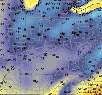
Current temperatures

Lows by Friday morning will drop into the middle 50s for many areas…
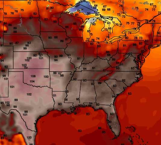
Afternoon temps rebound to the 80-85 degree range with a mix of sun and clouds. Some clouds will increase on Saturday and I can’t rule out a few storms diving in from the northwest. That’s on the cusp of some plains heat that tries to shoot our way for a few hours…
That gets smacked down by a powerhouse of a front arriving from the northwest on Sunday. Showers and thunderstorms will increase and carry us into early Monday. This will be the beginning of a prolonged period of well below normal temperatures. Check out the deep trough digging in…
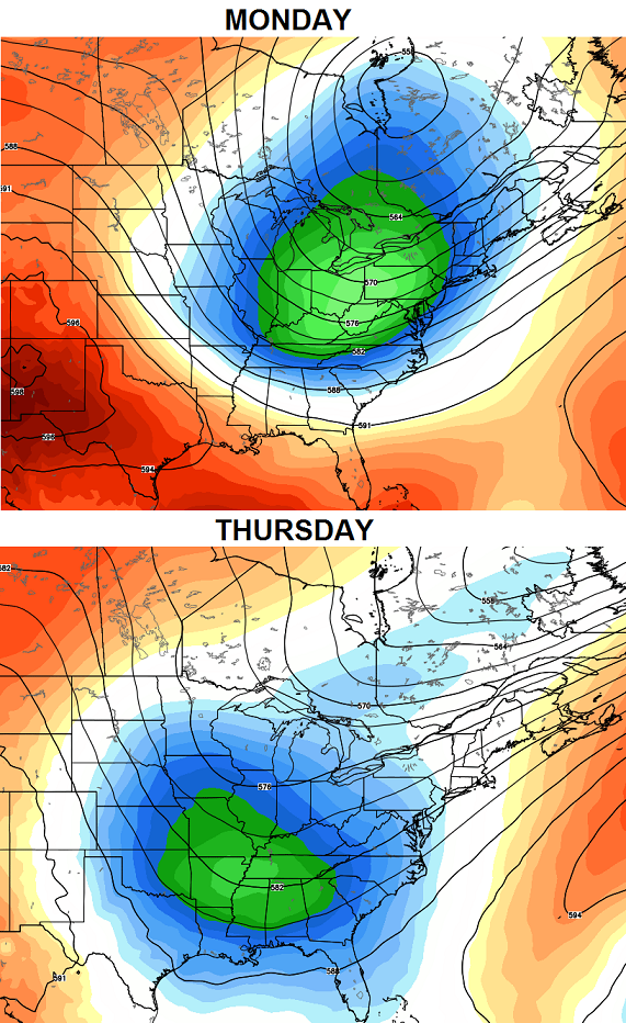
Record cool high temps and record lows could be challenged next week. Highs should run in the 70s for many days in a row with lows dropping into the upper 40s to low 50s…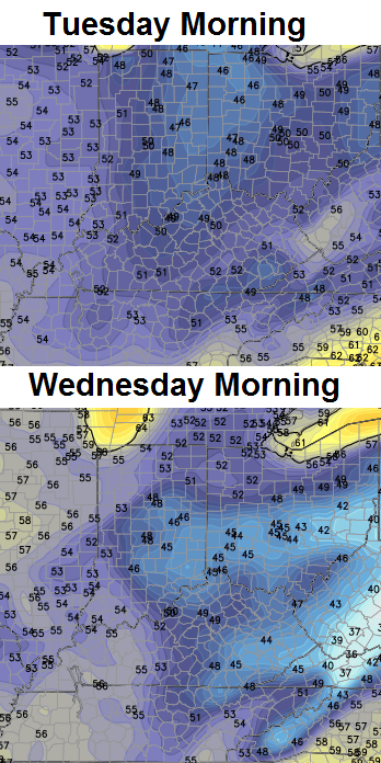 Summer is overrated anyway! 😉
Make it a great day and take care.

I am looking forward to this cool spell. I need to wash our windows and now I will do them all in a day and with a smile!!
Id be happy with just one 100 degree day, but that is likely too much to ask out of this Fal..I mean Summer we are in.
What a surprise Louisville is sitting at 80 degrees if you live at the airport.
Rain entirely missed my part of Lexington. Just enough rain fell to wet the pavement. BGA recorded 0.09″ while the Lexington mesonet site had 0.28″. I had a trace at my place.
Same at my house in frankfort, all this cooler stuff is great but the same areas keep missing the rain it seems?
Same here in Valley Station…just sprinkles.
Been having to use more tap water than rain water for the garden. However, I have enough rain water stored up to get me through August.
And the garden is doing pretty good. The spaghetti squash is the only plant that is underperforming…I only have 3, normal yield is 4-6. Still won’t be ready till August.
I know! And I think it’s all a timing issue every single time. I wonder if it’s because the day begins overcast with some rain and by the time the heating kicks in, all the outflow boundaries are south/east/west of cent ky? Even last night northern KY got rain, but it moved due east. It’s been so long since I’ve seen a thunderstorm.
Summer is not overatted……………
I tell ya if these cool spells keep it up I look for frost before end of August and First flakes in September.
A cool, cloudy and somewhat misty morning drive to work from Richmond to Moreland. Very nice! 🙂
This summer has been very bizarre when it comes to cool/cold fronts moving in to the area. Generally, we’re guaranteed to have a least a line of storms accompanying the front. This summer, we’ve had several call for storms, with 60, 70 and 80 percent chances of rain, and nothing. Very strange.
Agree, southeast ky getting rains now but here in frankfort less than 1 inch for the month, and this months almost over!
On average the dryer months are aug thru October!
Might take a tropical system to give a widespread soaker to KY!
Rain Rain Rain ! At least it keeps the river running ! Have you seen where the park service is doing ranger led hikes to Yahoo Falls this year ? If you haven’t, you should check it out! Go after a big rain! http://www.mccrearytourism.com/index.php/nes-events/item/172-yahoo-falls-hikes
Louisville is sitting at 80 degrees officially if you live at the airport.
We got quiet a bit of rain yesterday and early last evening.I woke up this morning thinking it would likely be around 80 with sunshine today.But it was not to be.Only a few peeks of sunshine and you had to look quickly not to miss them.No rain today but overcast all day and both thermometers have stayed between 65 and 70.As of now it is 69 degrees.[:>}
Wow what a strange feel to the air for July.I am starting to believe there might be something to that mini ice age cool down thing some are talking about.
I admit I enjoy the cool temps but I got my fill of those from October through April and now a bit concerned about no really warm days happening this year.
My goodness if this keeps up I am scared to think what winter may bring.