Good Thursday, everyone. Much needed rainfall is on the way to the bluegrass state over the next several days. Low pressure working in from west to east will bring rounds of showers and thunderstorms through the upcoming weekend.
Today’s weather will find us in similar fashion to the past few days. Highs will hit the mid and upper 80s for central and eastern Kentucky with 90ish across the west. Scattered showers and thunderstorms will be floating around and will increase from west to east late.
Current temperatures


Our low pressure moves in on Friday with showers and thunderstorms becoming widespread during the day. That action looks to continue into Friday night and early Saturday…
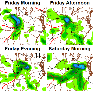
Low pressure working due east across the Ohio Valley in early August isn’t something you see very often. It will continue to spit out a few rounds of showers and storms into early next week. Beneficial rains are likely…
 We will have to watch for some local high water issues and the potential for a strong storm or two.
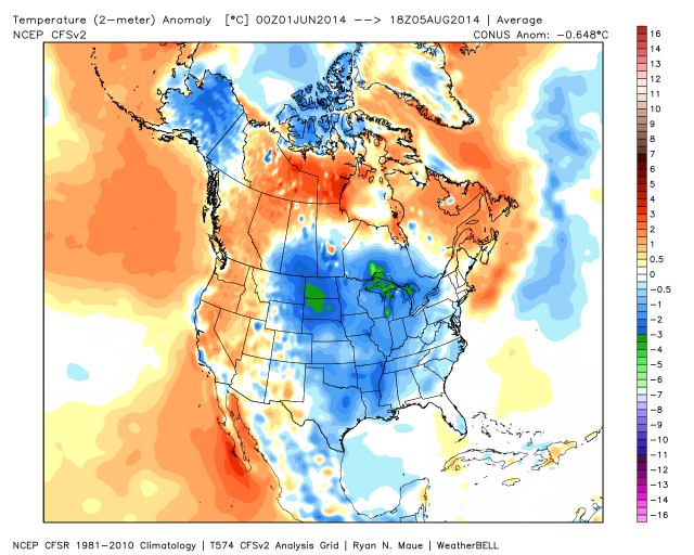
This will knock temps down a few degrees as our cooler than normal summer rolls on. We aren’t alone in that. Check out how much of the country is below normal since June 1st…
 Have a great day and take care.

Looking forward to the raining weekend. Any excuse to get me out of yard work :). Besides, I thought there should be at least 1 comment posted :).
Comments are uncommon in the summer months. I’ve noticed August tends to have the least commenters due to the weather this time of year. Want 400+ comments? Come back in winter.
Bring on that rain Chris, love the summer rains and smells that it leaves behind!
Does anyone know what this unusually cool summer says about our winter? Or are long range forecasts suggesting anything at this point? Much more action on here when there is winter talk.
The last two cool summers were 2004 and 2009.
The winter of 2004-2005 was very warm
The winter of 2009-2010 was the coldest since the 1970’s.
So I guess that is a 50/50 chance.
2009 is a good match to this year.
I hope your right!
A big YES for western KY right now! Radar is showing lots of rain moving in from the west. Let’s hope it doesn’t dissapate and keeps on with the rain they have been needing.
If we were to get some good soaking rains from now into fall, wouldn’t the wet ground allow for cooler than normal late fall & early winter temps? Oh yeah, and we have to consider an El Niño and blocking too, wouldn’t we? Chris has thrown some hints that early fall should be some cooler. Guess there are no guarantees, but Chris does very well.
Evening all. Looks like western KY is finally getting some beneficial rain. I am so glad for them! Looks like we are all in for a rainy weekend. Guess that’s not a bad thing either seeing ax how it is usually dry in September. Notice I said USUALLY. As our tipsy turfy weather rolls on, who knows? Have a great evening all. Thanks Chris for keeping up up to date!