Good Sunday, everyone. It is pretty much more of the same as far as our weather is concerned. Rounds of showers and thunderstorms will continue to push across the region over the next few days. That’s when we get another cool shot of air moving in. Sound familiar? That’s what I thought.
Showers and storms today will be especially prominent across central and eastern Kentucky. With a tropical feel to the air, watch for storms to put down a tremendous amount of water in a short period of time. That could cause some local flash flooding similar to what hit Bowling Green Saturday.
Showers and storms will continue Monday and Tuesday as a strong cold front moves our way form the northwest. The setup looks like something you would see during the cold weather season…
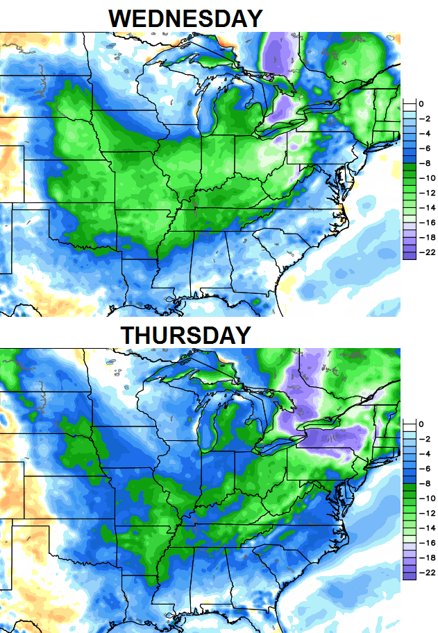
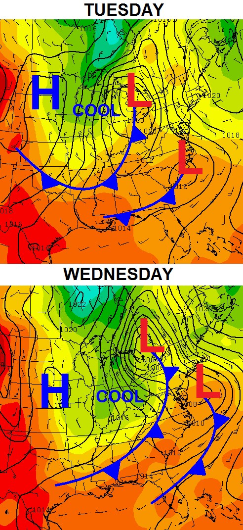 Very pleasant temperatures move in on our northwesterly wind flow for the middle and end of the week. Temps will continue to run several degrees below normal…
There are signs of a warm and humid pattern taking shape for the following week. The medium and longer range models continue to show that and some wetter times ahead. The CFS rainfall forecast through the middle of September…
 Some of the years I’m looking at as being similar to this one did produce some pretty good rains in September. As with anything, time will tell.
Spearing of rain…


Enjoy the day and take care.

I’m done with the cool weather
Me too, I’m done with the cool weather. Bring on the cold weather!
Close lightning & LOUD thunder at my house ATM
Sheeeesh! No more drought at my house – that’s for sure!
is there a drier place in Kentucky than Berea? Never seen anything like it. .02″ of rain in last 24 hours. It’s like a dome sits over this town.
If you got nothing in the past few hours, that would be wild.
Very little, just a slow drizzle that doesn’t add up to much in light of everything else that’s around us.
We deserve our own Mesonet based on the wide differences in precipitation during all seasons.
Remember how many times we missed out on snow that even 15 miles away received? Still holds true with plain old rain as well.
Poured rain all morning in Richmond.
3.1 inches in the Versailles rain gauge this morning. Very impressive. I think we’re good for the rest of August now.
Did the NWS in Louisville ever issue a Flash Flood Warning for all the rain that fell in Fayette County and surrounding areas this morning? Looks like they should have!
Yes they did issue a flood advisory I think? I know the nws map was highlighted light green over fayette county. But it wasn’t the maroon flood warning.
East Frankfort .20 in of rain so far, these heavy rains are very scattered in nature, some folks getting hammered others getting very little!
Intense rains again the past 15 min’s at my house in northwest fayette. We missed a lot of rain the past few days but today has got to be a good 5 inches of rain.
Wow! Storms strengthening over Lexington at the moment! After 4.11″ of rain so far recorded at the BGA, it wouldn’t surprise me to see totals by the end of the day exceeding 6″!!! Storm just blew through and one formed right behind it. This training of storms is ridiculous!
Chris, on your tweet about the .84 inches in the past 19 minutes, how exactly do you find that data? I have to wait until the top of the hour when they update on the 3 day history page on NWS. Is there a better way?
Im thinking the TV station has a rain gauge and the airport has a rain gauge CB im sure has one at his home. Im probably dead wrong but that’s my best guess. lol
Having this info *may* also come in handy during a snow storm.
He got it from the NWS Twitter feed though he didn’t retweet it. I know that a lot of info get gets comes from other people in Twitter.
Actually, no
My bad, shouldn’t just as-sume things like that. But it “seemed” too obvious since NWS Louisville tweeted “Just dialed into ASOS at KLEX. 0.84 inches in 19 minutes (404P to 425P).” But where do you get some of your info from CB?
No biggie. Appreciate all the info you bring to the blog! We get many things from the nws and emergency managers via a chat room. As I mentioned earlier, there is no real time information available from the ASOS sites unless the NWS dials in to get the info on occasion. With today’s technology… it’s a very outdated way of doing things. Take care and thanks again.
Yeah, I get frustrated because I know the NWS can do more than that. Thanks CB for providing much info and keeping the public aware of the wx dangers that are out there, you’re awesome! You are always dedicated to update the blog no matter what comes your way. And again, thanks!
Unfortunately, there is no real time data that comes directly from any of the available ASOS locations. That’s hard to believe in this day and age that the NWS is that far behind the curve in obtaining data. They do have the ability to dial in remotely to get information such as they got today. They will then relay that information to those of us in a chat room.
I think it may rain!