Good Monday, everyone. Weekend thunderstorms have dumped a ton of rain on several places across the bluegrass state. Sunday turned into the 4th wettest day on record for Lexington with more than 5″. This has set the stage for the possibility of additional flash flooding today into tonight as a cold front enters the picture.
Showers and thunderstorms will continue to come at us in waves today as the front presses closer from the northwest. We will also run the potential for a few strong storms going up. The big story will continue to be the tropical rains associated with these storms. These boomers can easily drop several inches of water in a short amount of time. The flash flood risk for today into tonight is elevated.


Tuesday will find the cold front blowing through here with cooler and drier air to follow. Isolated showers and thunderstorms will be around Tuesday as the front slips through. Temps behind this boundary will slip back into the 70s for highs with lows that may drop into the upper 40s to low 50s…
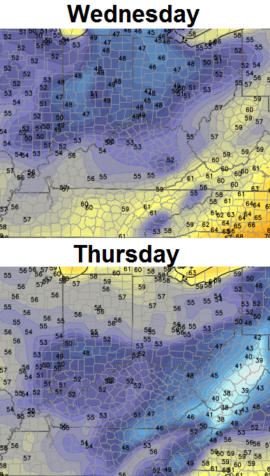 The closer we get to this blast, the cooler it looks. Some very pleasant weather is on the way for the middle of the week.
The end of the week into the weekend now has a wrench thrown into it from the European Model. This was the first model to sniff out our weekend system and it’s trying to do something similar for next weekend…
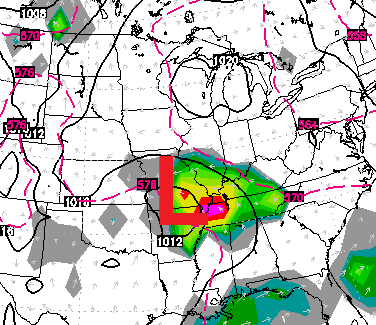 As you can see, it brings another low pressure scooting across the region. The rain and clouds would then keep temps well below normal…
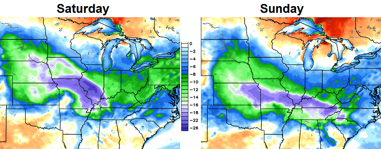 I’m not sold on this solution right now as the pattern should favor the return of warmer air. That said… the trend of the summer isn’t something we should ignore.
Have a great day and take care.

HRRR suggest a line of slightly stronger storms moving through south-central and eastern Kentucky this evening.
I kept getting flash flood warnings in my WKYT weather app yesterday and couldn’t understand why. We only got a couple sprinkles at the most where I was in Fleming Co. Now I understand why there were sent. Its pretty dry here in FC…I hope we can get some rain out of this system.
From drought to flood, that’s some weather whiplash!
few sprinkles today in frankfort, crazy how much rain is falling is places while other spots remain dry?
SW part of Jefferson County in Louisville wouldn’t be to surprised to see a Flood Advisory go up there judging what the radar is saying
almost best time of year, FALL/WINTER!!!!!!!!!!!!!!!!!!!!!!
Next to nothing here in our part of Carter Co. Over the weekend we only had a few sprinkles and so far today we’ve had nothing. I hate to see people flooded and then just a few miles down the road, folks are still near drought. Crazy weather. We can hope the rain becomes more even throughout the state, but I really don’t see that happening with this system. I’m gonna get my watering can and get busy.
Agree, the rich get richer, and the dry areas get dryer, strange summer indeed, flooding in one county dry in the next?