Good Thursday, everyone. Our cooler than normal summer rolls on across the bluegrass state. This pleasant air mass looks to carry us into the start of the upcoming weekend. That’s when we start to see some changes showing up. Those changes could lead us back into another stormy setup.
Speaking of storms… scattered showers and storms will be possible out there today as a weak cold front drops in from the north. Winds will gust up with a mix of sun and clouds. Highs will range from the upper 70s in the east to low 80s out west.
Current temperatures


Friday into Saturday look pretty good with highs between 80 and 85 in most areas. Some clouds will increase later Saturday and it’s possible for a storm or two to pop across the west.
Storms will increase from west to east Sunday and carry us into the first half of next week. A couple of systems will dive in from the northwest during this time…
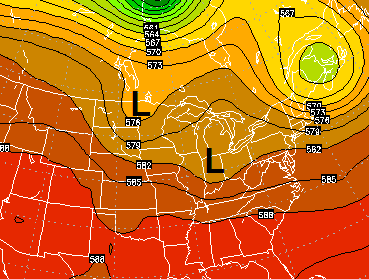
This will bring rounds of showers and thunderstorms back to the bluegrass state…
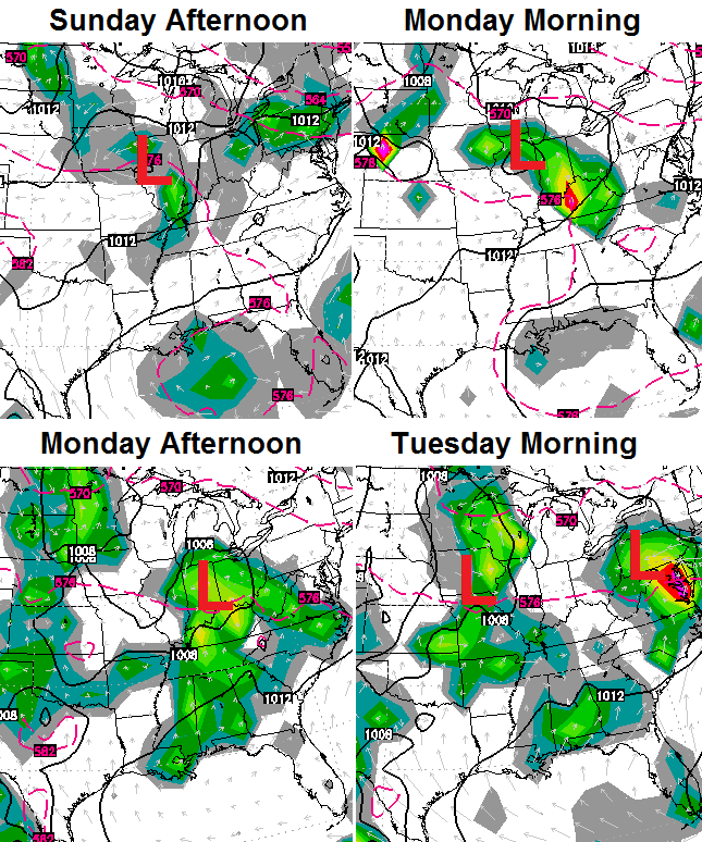
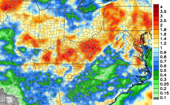
Locally heavy rainfall is a good bet with these storms. The European Model shows some healthy rain totals…
 The pattern will turn warmer, but that does not mean things are going to turn hot. As a matter of fact, when a warm pattern begins with rain, that is usually a sign it won’t hang around long. I guess time will tell. What would you bet on this summer? Yep… me too.
Have a great day and take care.

On days we’ve had a 70 per cent chance of rain (or higher) given we get no rain at all. This morning we have a 20 per cent chance and it’s pouring! What fun! At least it’s raining here for a while.
Thanks Chris. I have been enjoying the cooler evenings but I must say that I would not mind a few “summer “days. I enjoy something about each season and the way our weather has been, its kind of hard to tell what season it is, if one didn’t know. 🙂
I hope that the western parts of the state can get under some of that good rain. I know they had flooding problems with too much of a good thing last week, but hopefully it helped some anyway.
As long as we don’t have washouts, I am good with some afternoon showers.
Everyone get out and get a chance to enjoy this beautiful day! Thanks Chris for all you do. Happy “Friday Eve’ everyone! And remember…football season is almost here!!!!!
Another nice day here.I had to wait a couple days to mow the lawn because we had very little sunshine lately.Still it was wet in places but I had to get it done.With the rain it seemed like it grew 6 inches the last few days.Id did make pulling the weeds easy with the ground wet.
I know we need the summer days and looks like we may have a few coming up but I am so much enjoying the brisk mornings and late evenings.
Hopefully this will post.I know certain words blocks the post.Sometimes I just give up when I can’t figure out which word I am posting that deletes my post.That green stuff that grows on the lawn is one word that won’t let me post.
Hope you are enjoying the break Chris.Have a feeling this winter you won’t get many of those.