Good Saturday, everyone. We are about ready to head back into a very stormy setup across our region and this will set the stage for heavy rainfall. Rounds of showers and thunderstorms will work in late Sunday and that action should continue for much of next week.
Today will feature a mix of sun and clouds with highs in the 80-85 degree range. The clouds will thicken some this afternoon and isolated showers and storms will try to pop across the west and central parts of the state.
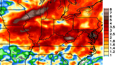
Current temperatures


Low pressure will work our way late Sunday and slowly work across the region into Monday. Showers and thunderstorms will increase during this time. Here’s what to watch for…
– Storms will come at us in waves from Sunday through much of next week. That does not mean it’s going to rain all the time!
– A few strong storms will be possible with hail and high winds the worry.
– The biggest worry will come from the torrential rain potential. Amounts of 1″-3″ of rain are possible over the next week. Much higher amounts are possible for areas getting in on repeat thunderstorm action. Local high water issues will be possible.
The forecast models continue to dump a lot of rain on the region in the next week and change…
 I will have updates as needed. Have a great day and take care.

Where did Jim Caldwell go we have a new weather man this morning
Odd, he’s still listed on the WKYT station info.
http://www.wkyt.com/station and on the weather page.
I don’t see anyone new listed there.
We decided to split the weekends up because that’s a tough turnaround for anyone to make. Mike Linden will do weekend mornings while Jim continues to do weekend evenings.
Good Chris I like Jim I’m glad he still with us
The weather outside is brutal this morning. Mother Nature, please send a warm front pronto!
Interesting summer. More days with lows in the 50’s so far (14) than highs in the 90’s (12) at Lexington.
Only 1 90 at the mesonet site. That’s much more reliable than the new blowtorch temp sensor at the airport. 😉
20 degree spread (48 ~ 68) in overnight temps across the state.
Here comes those mid-to-high 60s dew points, making the actual temps irrelevant.
So far it hasn’t reached 80 here today.Very overcast.Humidity around 60%. I always check the high and low for the date each day.
According to accuweather it was 102 in 2007 and the low was 47 in 1963.So I guess all we have to do is look back far enough and we can find the unusual temp variance.Was 80/61 for 2013.So today is really not that much different from last year on this day.
Enjoying the sleeping at night with just the fans going and actually feeling a bit chilly at wake up.I suppose within a couple of months this will seem downright warm.
What are your thoughts about this winter?
Yea I wish Chris would give us some teases like he used to I really miss how he used to always look down the road
Chris posted his thoughts regarding the winter outlook a couple weeks back.Don’t think there was a whole lot of detail he could tell us at that time.It was mentioned in the July 30 post.If he has posted regarding it since then I have missed it.