Good Tuesday, everyone. Several areas of the state have been hammered by flooding rains over the past few days. With the setup favoring rounds of storms continuing, additional flooding problems will be possible in the coming days.
As noted in earlier updates… a few strong or severe storms will be possible during this time. We have the potential for a cluster of big boomers working our way from the northwest later today into tonight. Much of the day should be dry.
Still, flooding is the greatest threat of the next several days. The models continue to point toward a lot of water possibly falling across central and eastern Kentucky…
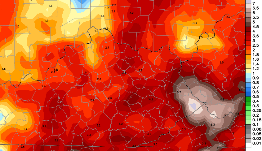 I want to stress how this pattern has flash flooding written all over it… especially across the eastern half of the state. If you live in a flood prone area, please do not take any thunderstorm lightly. They can dump a tremendous amount of water in a short amount of time.
Now, it’s NOT going to rain all the time and you may not have it rain each day where you live. Rounds of storms means just that… it comes at us in rounds with steamy air in between.
Western Kentucky still looks to get in on some hot weather this week and a day or two can turn very toasty for the rest of the state. Enjoy it, much cooler air is coming in for next week and that may carry us through Labor Day Weekend. The GFS Ensembles have a nice look…

I have you all set to track today’s storm threat…


Today’s risk area

Current watches

Possible watch areas 


Have a great day and take care.

You know, usually our mowers get a break in August.
Not this year.
I cut mine Friday for only the second time since the first week of June. I’ve had some good rains the past week and things have greened up again. The trees are still pretty stressed as a lot of that rain came in downpours and never soaked into the ground. Dig down a few inches and it’s still pretty dry.
Yep…everything in my Mom’s part of the state is lush and green.
My local forecast this morning has 90’s for Saturday-Monday. And I’m not in the Western part of KY. Are they forecasting off the GFS like Chris sometimes harps on?
We have mowed more over the past three weeks. Of course, we have mowed our own yard,( and plan to do it tonight) but we have also went over to our daughter’s house and mowed their yard because they are both working extra hours as college rolls back into session along with football season. Last night, we went to our other daughter’s house and helped our son in low mow their big yard, as he has been working out of town. Before we mowed theirs, we mowed our own, and now the cycle is back to us again! 😉 I will not complain about the mowing. I would rather have to mow as have it be so dry everything is blowing away due to dust. Chris, never like to hear ‘possibility of severe storms’ in your forecasts, as you are usually spot on with those things. Hoping that no one sees that!
Have a great Tuesday, everyone. Thanks Chris, for all you do.
Will be watching you on the evening edition.
Ahhh…..upper 80s and 90s forecast here in Eastern Ky. all the way through next Tuesday per the NWS…..Finally Summer!
Won’t happen
Lol….Never seen anyone get so PO ed at hot weather
Ha… just being realistic. This has been a super cool summer. We have a soaked ground with green grass. Throw in thunderstorm clusters and clouds and that’s not a good recipe for those kinda temps. Can a day or two hit 90? Maybe… but it has to be cloud free from wall to wall.
Those Mesonet precipitation counters across the state sure received a well deserved break since midnight (only 4 stations reporting precip at 6pm and the highest was 0.03″). Let’s hope the reprieve all day lasts as long as possible for those who truly don’t need anymore rain coming down.
Yep… much of the state really need a prolonged break. Doesn’t look to happen, though.
Seen some forecasts for 89 as the high today. Mesonet says high was 83 (was 82 at my place) but yet weather.com says the high was 89 at 3:25. NWS says the high was 83 as well.
NWS shows mid-80s through Saturday. Weather.com and accuweather.com show the 90s breaking out. Accuweather has the 90s through next Thursday. Weather.com only has the 90s through Saturday and then returning to mid-80s.
Now I am wondering if it does get really hot. It was sunny all day and we did not reach there high forecast but I am wondering if we can get there at all. And if we do how that will effect the storms when they do come through at times. Nothing like 90+. Then rain dropping it off to 70-75. Followed by the sun warming it back up. Hard to work outside in that.
Weather.com and accuweather forecasts have no human input and come straight from the GFS. Models have no idea how wet the ground is or how lush the vegetation is and that plays a huge part in temps. If the GFS had been right this summer… we would have had 30 or 40 90 degree days by now.
All I’ve heard is rain, rain, rain. Where the heck is the rain?? All I see is sunshine and warm temps?? Models are junk right now. I guess.
3″-5″ totals with flash flooding in several areas Sunday and Monday. I said most of today would be dry and have made it a point to say the storms would come at us in rounds and it wouldn’t be a constant rain by any means. Hope all is well. 🙂
Yes you did say rounds. Just seems a bit under performing. Do you see this wetter and cooler than normal pattern continuing into fall/winter?
I work outside just about everyday and as far as I’m concerned the temp is irrelevant. It’s all about the dew point. I’ve got to the point I can just about guess the exact dew point without looking.. 75 temp with a 70 dew point is much, much, much, much more uncomfortable than 90 with a 50 dew point.
I’m not complaining though, just give it a couple more weeks and it’ll start to “smell” different out there. Dew point will start going down. Little bit of crisp in the air. The sky will turn “bluer”. There is nothing like fall, absolute best time of year IMO.
I believe we’re going to go right into fall…has anybody noticedthe trees are starting to turn colors already.is a sure signearly falland quick winter.Farmers Almanac predicts bitter cold and snowy winter…
Saw this on one of the news sites.News story included the WeatherBell
winter outlook.
http://live.wsj.com/video/this-year-winter-shaping-up-to-be-colder-snowier/857DA4C5-FF31-46EE-A859-CCD7CFEDBE4E.html#!857DA4C5-FF31-46EE-A859-CCD7CFEDBE4E
Does anyone agree with this outlook?Hopefully the link will post.A bit concerning if it holds true.
Check out the live weather-cam on WAVE3 in E-Town….that lightning is SCARY, and the clouds are creeping me out…..