Good Friday, everyone. Rounds of showers and thunderstorms will continue to work across central and eastern Kentucky through the weekend. The western half of the state will swelter with heat index values hitting triple digits at times.
The axis of the storms is actually going to expand toward the west today and through Saturday and Sunday. That means more of the state will likely see some action than what we went through on Thursday.
Here’s a look at what I’m talking about…
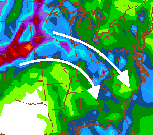
I would expect a round of two to actually get pretty far into western Kentucky at some point this weekend. Still… central and eastern Kentucky will see several rounds of storms working in from the northwest. This will be the favored corridor for a few strong to severe storms and local high water issues.
High school football action kicks off this evening and we could very well have some storms for a few of the games.
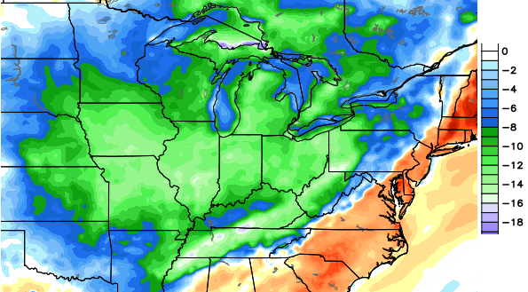
The threat for storms will actually carry us through the middle of next week. That’s when a strong cold front moves through from the west…

The timing of that front is up in the air because of a possible tropical system across the east or southeast. Whenever the front does finally pass through, much cooler air should filter in behind it. Below normal temps are possible by the end of next week into Labor Day Weekend. This is from the European Model for next Friday…
 In the meantime, let’s track some more storms…


Today’s risk area

Current watches

Possible watch areas 


Enjoy your Friday and take care.

Thanks Chris. Right this minute I am getting more heavy rain in Cold Spring. At least there is no wind or lightning to complicate matters.
This is one of the more impressive ring of fire patterns I’ve seen in a while.
T-storms really popping up in West Virginia, perhaps a sign of things to come for much of Kentucky and Tennessee.
Dewpoint is up to 75 in Lexington. That is getting into impressive territory. 81 is the highest dewpoint ever recorded. The last time that happened was July 12, 2011.
Yea, it was 74 in Nashville earlier today …….now “just” 71. Air temp has been around 91/92.
As much as my wife and I like the whole house fan in our hallway ceiling, it’s way too humid for even the fan. But this of course has been a cooler than normal summer so were going to save a lot on the AC bill this season anyway.
Dewpoint in Fayette Mesonet is interesting. It was in the high 60s Wednesday evening, same as Madison site. Left the KY after seeing Harvey and it felt cool and breezy outside at about 920pm. Checked and the dew point was still the same, just as Madison’s. Get back to Berea and it’s the same muggy crap that I left earlier before heading to Lexington.
I thought cities worsened heat due to all the metal and pavement (heat island or whatever)? I could not figure out how it felt so comfortable in downtown Lex and even on Richmond Rd. past New Circle when all the data says that it shouldn’t be. Even if it had rained just prior to exiting the theater, wouldn’t that just make it feel even more humid? Puzzling.
Also, Chris Mercer, don’t bother emphasizing the reality of comfortableness and dew point readings. As long as the temp is below normal highs, CB and the other mets will call it “cool” even if it doesn’t actually feel any cooler to people who are outside often. “white collar bias”, maybe. Heh.
Lightning count increasing across eastern KY like near Hazard. Still relatively quiet north of my location in Valley Station. Weak cap in place still holding.
Dewpoint is currently 75 degrees at my house. Temperature at 90.
Downpour developing just north of Frankfort…lightning tracker just showed first cloud to ground strike…ok now 3.
http://www.lightningmaps.org/realtime?lang=en
current lightning strikes
Lightning continues to be a big issue with this cell slowly moving southeast. However, flooding issues will become an issue shortly for Owen, Franklin, and eventually Scott counties
Power outages on the rise in Franklin county and the rural sections of Owen county. This from LGE and KU power.
No rain at all here yesterday and none so far for today.It has felt hot today for sure.The lawn is still damp in the shaded areas from the earlier rains and it looks as if I hadn’t mowed at all before the rains.Thermometer on the front porch in a shaded area had 94 on it earlier.The weather sites are showing our high at 89 today but I noticed they show the dew point at 71.
I know we needed a few warm days and it will make many happy but I am already looking forward to the cool down.I am trying not to rush to soon wanting cool weather.I think back on how burned out I was with the 6 months long winter and tell myself to be patient.
Storm may be bowing out as it approaches Lexington.
Lightning count finally ticking down but still dangerous.
Big storm came through northwest Lex. Amazing how dark/creepy looking it got, and now it’s pouring rain again and just now a big boom of thunder. I think there may have been a small down burst because it got super windy suddenly and raining sideways. Ironically, the airport isn’t looking to record a lot of this rain since it’s slightly missing them (so far)
Looks like Floyd co. Is getting absolutely smashed.
My power just went out briefly from a huge lightening strike. It’s back on. This lightening is CRAZY…!! Power hardly ever goes out in this area of lexington compared to other areas of the city I’ve lived in (knock on wood)
Yeah that was a pretty weird flicker.