Good Saturday, everyone. The stormy pattern we’ve been tracking for well over a week continues and shows no signs of letting up this weekend. Storms will come at us in waves as the axis of storms shifts farther west into the bluegrass state. This puts western Kentucky in play for some storms that can cause more issues.
Speaking of issues, flooding was common with the Friday evening storms. Many streets in Lexington were flooded and areas around Ashland had big time problems. The hardest hit area was around Prestonsburg in Floyd County. Much of the downtown area was underwater.
High school football games were postponed in many areas last night because of the storms. Many of those will be played tonight, but could face additional storms.
The storms out there today and Sunday will focus on the entire state and will continue to come at us in waves. These storms can put down tremendous amounts of rain and pack a ton of lightning.
Off and on storms will take us through the first half of next week. Once we get into the middle of the week, a strong cold front will approach from the west. That front SHOULD clear the area later Thursday or Friday with much cooler air working in for the Labor Day Weekend.
The one thing that could impact the timing and set of it all would be a possible tropical system developing in the Caribbean. The models want to keep this storm off the coast as our front passes through…
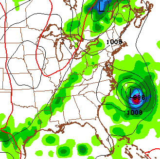
It’s still way too early for anything definitive on that system, so we will wait to see what happens with it.
In the meantime, let’s track some storms…


Today’s risk area

Current watches

Possible watch areas 


Enjoy the day and take care.

Thanks Chris. Since the storm on Wednesdsy night we’ve been rain free here in Somerset. Have seen lightning from the storms around us but have been lucky so far. Something tells me our luck will run out this weekend ! Thanks for keeping us informed. Have a great (and safe) Saturday everyone.
I see a train load of storms tracking right toward the vicinity of Louisville, if they hold together for the rest of the daylight hours.
Dewpoint is 75.8 at my house in Valley Station. Temperature is 91. Just finished mowing the backyard. I looked like it rained on me, completely soaked in sweat.
I can’t remember many days more miserable than this one.
Lightning strike fries motor in the Kroger Deli…something was still burning and it wasn’t dinner.
Meanwhile next door, Papa John’s did not have telephone, internet…figures, placed an order there and they never got it. NO pizza. Oh well, I’m making my own with all of those bursting tomatoes from my garden.
1.7″ over the past 24 hours at my house in Valley Station
Pouring rain in northwest Lex. Not a violent storm like yesterday, but more moderate heavy rain with some thunder. But a few min’s ago, I was hearing something that I wasn’t sure was thunder or not. It sounded almost constant..My back yard has gotten so much rain the past few weeks!
Me too, its like a constant thunder here in south Lex but it has stopped a while ago.
Meanwhile here in Richmond, we miss out on rainfall yesterday and today. Feast or famine.