Good Tuesday, everyone. We are rolling our way toward the end of meteorological summer and into the start of Meteorological Fall. That also means the long Labor Day Weekend is upon us, so the forecast always takes on added importance. Unfortunately, it looks like our stormy pattern will still be going strong.
In the short term… steamy and sometimes stormy skies will dominate the day across Kentucky. The west will continue to bake in the 90s with the east in MUCH better temperature share. A storm or two will continue to bubble up.

A cold front will drop in from the north and northwest late Wednesday. This front will put the brakes on across the region as a broken line of showers and thunderstorms sweeps in…
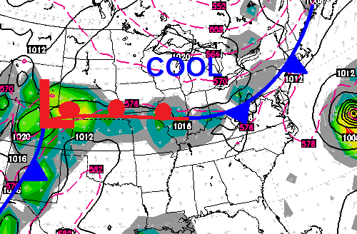 That will knock temps down a few degrees into Thursday as scattered showers and storms continue. The boundary will then lift back to the north as low pressure works toward the east from the Plains. As that happens, tropical moisture from the Gulf will work our way into Labor Day Weekend. The end result will be an increasing amount of showers and thunderstorms…

There’s a lot of juice available in this kind of setup. That could very well lead to some troubles from torrential rainfall.
Have a great day and take care.

So…it looks like that pattern that has been bringing us cooler than normal shots of air is finally taking a break?
Thanks Chris. Was planning to paint the garage this weekend, but not sure how well it would dry with this kind of a set up…..may have to wait on that for a bit. I really hope that the moisture set up gives western KY some much needed rain over the long weekend. I would almost bet that they would not mind having some raindrops on their Labor Day celebrations. If I am wrong, sorry, western KY. No harm intended. Have a great Tuesday.
Covington has has 3 straight days with a high temperature of at least 90. Seemed far fetched about this time last week but turns out the forecast was spot on. The ground up here might be a tad drier than other locations in Kentucky however (except Western Kentucky).
I have been meaning to say this for quite a while. We are extremely fortunate to have a meteorologist of Chris Bailey’s caliber here in Central KY. My occupation has taken me to numerous places in the US and over 80 countries worldwide. As you can imagine, I have seen A LOT of climate and day-to-day forecasting. There are few people I have run across who are as accurate as Chris and certainly NONE in this region of the country.
That doesn’t mean i LIKE all his forecasts (like the ones we are presently experiencing). 🙂 Bring on the cool stuff.
But, I can always take his insights to the bank. Thank you, Chris, for your service to the region and for the time you take to keep us informed on this blog.
yes, he deserves a standing ovation..
Yes Chris Bailey follows well in the footsteps left by T.G. Shuck and of seasoned Meteorologists like James Spann of ABC 33/40 in Birmingham/Anniston Alabama! No one presently in Kentucky can even touch him!
As much rain as Louisville has gotten as of late somehow Louisville keeps busting the 90 degree mark with ease 7 or 8 straight days of 90+ temps thats strange. 94 the official high temp today. Oh wait, my bad the official reading is taken at the international airport where commercial and cargo jets come and go on a constant bases. So the actual true temp was probably upper 80’s, unless you live at the airport.
Sorry Virgil not sure why my post got connected with your post