Good Saturday and welcome to the Labor Day Weekend. Rounds of showers and thunderstorms are developing across the state today. This action will be rather common over the next few days and that’s not good for outdoor plans. This won’t be a total washout of a weekend, but have a backup plan for whatever it is you have scheduled outside.
Tropical air continues to push in from the southwest and is coming straight out of the Gulf of Mexico. This is very deep moisture that reaches into the upper levels of the atmosphere. This 500mb relative humidity map shows a heck of a conveyor belt of moisture upstairs…
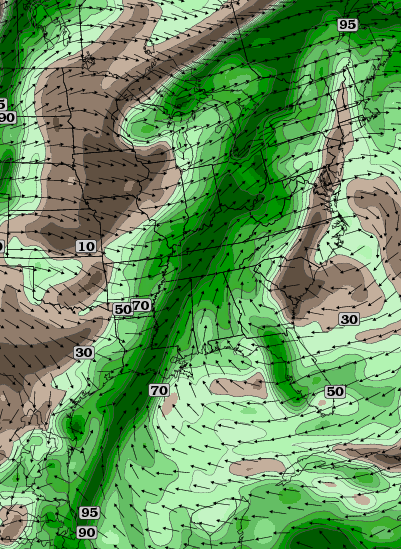 We know the lower levels of the atmosphere are loaded with water, but when you get that much water upstairs, that ups the ante for heavy rainfall. That’s especially when you consider the source is a tropical disturbance from the Gulf.
The showers and storms today will increase from southwest to northeast throughout the day. Rounds of boomers will carry us into Sunday and Monday with some dry times in between these rounds.
This is a setup that can produce additional high water issues for some areas. This amount of rain should also boost several locations toward their wettest August on record!
The pattern into next week continues to look steamy and stormy as September starts like August ends.
Let’s do some Saturday storm tracking…


Have a great day and take care.

It’s very funny that when “the blog” latches onto a pattern a week out, it gives itself a big old pat on the back, but when it is wrong, it is swept under the rug. “The blog” ruleth everything weather.
Not sure what you are saying.Not like any of the forecasts are deleted so anyone can look back on them if they wish to.
Most would have to agree that the forecasts on this blog are very good and Chris spends a lot of time updating anything that is important.Always very detailed too,which is great for the ones of us that don’t know a whole lot about how weather works.
Beth is a ray of sunshine on a cloudy day.
Beth has don’t nothing but cause trouble for “the blog” and fight with fellow posters for years. She’s been put in timeout on two separate occasions before. She is facing a lifetime ban after today. Enjoy your final hours. Rolo will be serving a last meal. 🙂
She still owes Todd $100 too.
It’s not swept under the rug. What does that even mean? What is that? When we have system that under performs, he, along with other comments usually acknowledge it.
Thanks Chris. Got a long weekend and looking forward to relaxing. Going to do a little laboring to do but rain won’t affect that. As far as pat on the back, I will give the blog one. It is my go to source for weather, period. My suggestion to those who are not fans, find another blog to follow. Have a great Saturday everyone, and GO CATS!!
Or they should make their own blog and see how easy is is to forecast and type up a blog.
The more popular one gets, the more criticism one gets.
This 500mb relative humidity map shows a heck of a conveyor belt of moisture upstairs…
This chart was really impressive. Thanks for sharing.
For a change, I just had normal sweat yesterday as my dewpoint temperatures were in the low 60’s during the heat of the day compared with excessive sweat earlier this week.
You know this hot stretch is bad when I have to resort to setting some type of sweat scale.
Yeah, yesterday was the least bad day of the past 10 or so. Looks like it will be close if Louisville hits 90 for an 11tg straight day as the rain is only a few hours away. Currently 86 at the airport with a few point of 70 degrees. I’m showing 89 at my house so it’s still pretty hot and humid out. I’m over it and ready for fall.
Sign of things to come???
Western KY’s Barkley Regional airport drenched with 2.30″ in one hour
About 45 minutes ago Shively easily just picked up 1/2 to 3/4 of a inch of rain they had a decent storm cut through there.
As CB touched on in his recent tweet, central Tennessee becoming very active. Here in Nashville, we’re about to get clocked by a strong t-storm. So watch out Bowling Green, and eventually Louisville, Lexington, etc.
Hopefully not a big sign of things to come for Kentucky and Tennessee; several counties in TN now under flood warnings including here in Davidson County (Nashville).
Several close lightning strikes.