Good Tuesday, everyone. The Labor Day Weekend is now in our rear view mirror and it’s full steam ahead into September. Rounds of showers and thunderstorms have been common of late and we have more of the same on the way today. The overall pattern looks to continue to be skewed stormy over the next few weeks. Yippee, more rain… said no one.
Today’s storms will be working in ahead of a cold front. Some of the storms could be strong or locally severe. High winds and hail would encompass the severe threat. All of the showers and storms will have the potential to put down very heavy rains. I have your storm trackers at the end of this update.
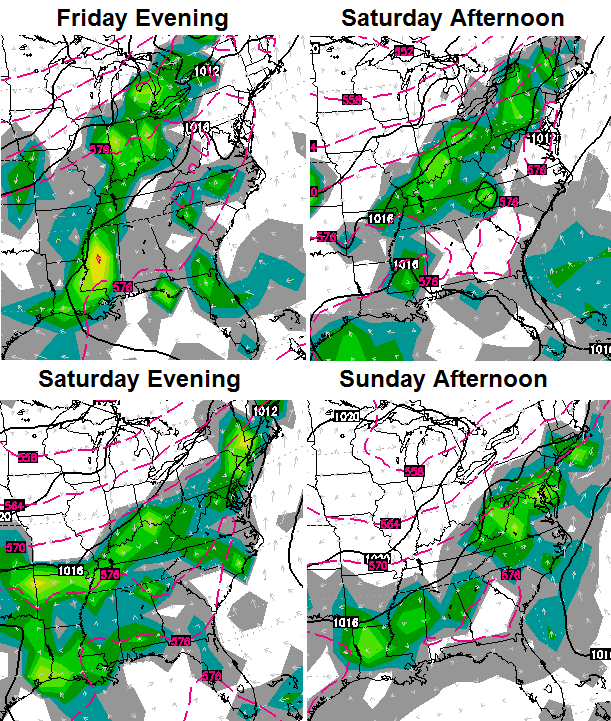
Scattered showers and storms will be possible Wednesday into Thursday as steamy temps return. This will set the stage for more widespread showers and storms coming our way this weekend…
 This has the making of another decent rain maker and could also spawn a few strong storms across our region. Pleasant temps will filter in behind that front for the end of the weekend into early next week.
The pattern later next week is likely to feature quite the setup across North America. It’s one that may place us between the heat in the southeast and cold air moving into the north…
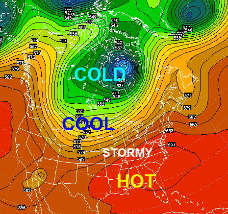 That’s a pretty energetic jet stream and likely means additional rounds of showers and thunderstorms.
Speaking of thunderstorms, let’s track…


Today’s risk area

Current watches

Possible watch areas 


Have a great day and take care.

Saturday afternoon/early evening has been looking consistently wet for quite some time now, unfortunately.
Meanwhile, here’s something from the NWS in Missoula, MT that should some folks excited for the future:
.AN UNUSUALLY STRONG COLD FRONT FOR THIS TIME OF YEAR WILL CAUSE
RAIN AND SNOW IN GLACIER NATIONAL PARK TONIGHT AND WEDNESDAY.
Climate Prediction Center expecting probabilities of at least 50 percent that Kentucky will see above normal precipitation through the middle of the month.
SPC has brought back a Slight Risk for severe wx, this time for southeastern Kentucky and northeastern Tennessee. Strong damaging winds the “convective” threat with the highest risk. A lot lower risks for large hail and especially twisters, although as tweeted by CB some nickle-size hail being reported. Can’t forget the danger of lightning strikes and some isolated flooding.
My kingdom for a radar hack that allows rain to show up as snow instead!
Interestingly enough, on Monday I experienced one of the hardest rains I’ve ever seen in my life along the same area of I-75 just north of Berea as I previously experienced the hardest snowfall. I can’t decide if that is cool or just creepy.
just thought I would give a shout out to the warning system for northern Madison county. the sirens went off for a thunderstorm warning right after the rain quit. now that is handy.
I have a 9am flight out of CVG on Saturday morning and sure hope the rain holds off until after that.
Quick hard hitting storm just went through frankfort!
Couple of rounds of storms in Lexington today. August and September are usually two of our driest months of the year. Yesterday’s low in Lexington was 74–that is extremely high for any time of year, but especially as we move into September.