Good Wednesday to one and all. The middle of our shortened work week is bringing many of us a small break in the stormy weather pattern. This means we get a couple of days of mainly dry weather. Don’t let it spoil you… rounds of showers and storms return for the upcoming weekend.
A weak cold front has slipped just to the south of the state today and is bringing in some dryer air. This dry air will make for a fairly comfy day with low and mid 80s for many with a mix of sun and clouds. There is still the chance for showers and storms to go up across the south and east. Some of the late night model runs are pretty aggressive with rain hanging tough in these areas.
Current Temperatures


Thursday will see temps and humidity levels on the rise. The west should hit 90 with mid and upper 80s across central and eastern Kentucky. Once again, a few showers and storms will be possible. Higher chances will be in the south and east.
Storm chances increase on Friday as our stormy pattern returns. Showers and storms look to become widespread as we roll our way into Saturday…
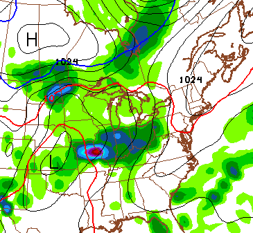
Locally heavy rainfall and a few strong storms will be possible. Some storms will linger into Sunday as a cold front sinks in from the northwest. That will introduce some pleasant temps to our region late Sunday and Monday.
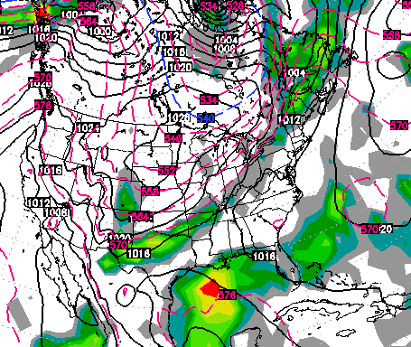
That nice weather won’t last long as more storms sweep in by the middle of next week. This is when the pattern threatens to turn very stormy…
That setup comes as we find our region sandwiched between heat in the southeast and chilly air in the northern plains. That should send a shot of cool our way at some point late next week or the following weekend. The tropics may have something to say about that. The GFS and European Models are both showing another tropical system developing in the Gulf…
Have a great day and take care.

Seems like there has been a lot of cold fronts sweeping down this summer..Hopefully the pattern continues and not shift to something ugly for the upcoming winter..Some still think we are on track for a weak to moderate EL NINO…Weak el nino with a +PDO may bode well with the polar vortex on our side of the globe..But let’s enjoy fall with all it’s wonderful colors before we worry about winter..Hope everyone has a great day..
How was there not a Dense Fog Advisory for the Frankfort area this morning?
“A weak cold front has slipped just to the south of the state today and is bringing in some dryer air. This dry air will make for a fairly comfy day…”
Dew points have been in the 70s or upper 60s most everywhere all night and now all day. I don’t see any changes from what we’ve been experiencing lately. Where is this “comfy” air that was supposed to be here so it could disappear tomorrow?
Upper 70s and low 80s across central and eastern Ky for highs today. Yep… no change at all. BTW… your act is wearing thin.
Check your data for Madison Co., and the dew point reading again. If there was “comfy” air somewhere yesterday, then I just couldn’t find it here or otherwise. I guess we just disagree on how air that moist can be considered comfy for anyone, especially those with breathing problems.
Like it or not, I actually look at your forecasts…and others…for gathering data and information. I parse that against what actually happens. Sorry if I’m not the cheerleader, but you have plenty of those around here already, the devil’s advocate position is usually empty. Though, as you might remember, I’m also quick to switch back to the ‘Jedi’ side on the rare occasion when too many people are piling on you. I’ve been here since month 6 of the original WKYT blog, so no “act” going on, just want to see you be the best you can be.
tl:dr disagree about forecast, high expecations for you due to ability, still support the cause.
Taking a few short minutes to dig a little deeper can help one avoid foot-in-mouth disease……..although kind of moot if it’s done on purpose to stir the pot only for the sake of stirring the pot.
CB already mentioned the air temps being pushed down.
True, more southernly stations like Somerset had virtually no change in dew points. But take Louisville (SDF) for example; after being in the low 70s, SDF dropped to 65 and is only recently back to 70.
Many northern KY stations still currently have dew points in the low to mid-60s.
Go back and look at the readings for central KY, and other parts of the state that aren’t sitting next to the Ohio river. Nice cherry picking and personal insult, btw.
How many stations statewide, reported in as dropping dew points significantly so as to allow for the air to feel as it was described? If everywhere else but my area was experiencing the comfortable air…which, btw if you think 65 dew point is comfortable, you must not work outside very much…then I would have stated as such.
Also, I noticed you posted at 12:04 AM Thursday morning. You do understand that the forecast said the front had already pushed through *to the SOUTH of the state* by Wednesday morning? Thus, while I am checking the dew points during the day to see when the comfy air is getting here, I didn’t see any change. If the forecast only pertained to the areas of the state which you feel experienced a brief time of comfortable air, then I supposed you’d have a point. Alas, it was not.
THIS CLOSE my man. Yes I know you’ve been with the blog from day one, Tommy. You now only stir up trouble.
LD give it a rest good grief.