Good Friday, everyone. The weather pattern for the past month has been as busy as you will ever see this time of year. Guess what? This looks to continue through the next few weeks, but it will likely come with a twist. Blasts of fall air look to get into the mix.
Let’s start with today and roll forward.
Temps will be super steamy with mid and upper 80s in the east with low 90s in the west. A scattered shower or thunderstorm will develop as the day wears on. That could impact a few high school football games.
Showers and storms will be likely on Saturday as a cold front slips in from the northwest. It’s not going to rain all day, but keep the umbrella or poncho handy. That front works to our east and south into early Sunday with a leftover shower possible in the east on Sunday. Highs look to be in the upper 70s to around 80 across the state.
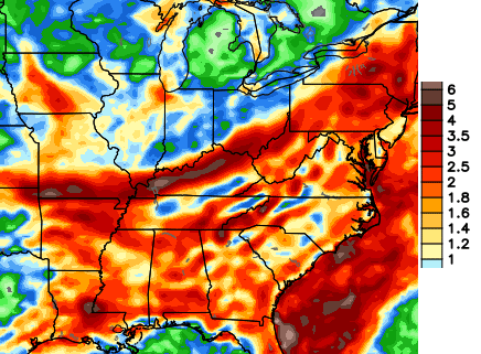
Scattered showers and storms work back in early next week and this may set the stage for another round of torrential rains by the middle and end of the week. That’s when we find ourselves in the transition zone from summer to fall. Torrential rain producing thunderstorms are a good bet. Look at the 7 day rain numbers…
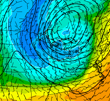
That’s a setup that COULD cause some issues and one we need to keep a close eye on. The air that sweeps in behind this system is straight out of the middle or end of October…
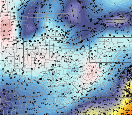
The GFS model is going crazy with the potential for record cold next weekend. Check out some of the forecast lows…
That would be incredible to see for this time of year. Again… it may be too cold, but the overall setup has a lot of other model support. You may even hear about snow in the Rockies and the far northern plains. Wow.
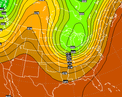
The GFS says another big shot of chilly air comes in behind that the following week…
 Have a great Friday and take care.

Could it really be the last possible 90 degree day for all major KY reporting sites? Is the real sticky humidity type of heat gone already? Weather like today, will become rare from now on as GFS and ECMWF throwing constant cool to cold shots starting with the one coming late tomorrow. If we lived up north towards Duluth, MN, we’d be having highs in the 40’s next week!
One of the craziest thunderstorms I remember was in September of all months and it was around midnight when it started. It lasted for 2.5 hrs and in that 2.5 hrs, it was like being in the height of a storm during a down burst.. I think it rained 7 inches. This was when someone was swept into a storm drain from flooding and killed I believe.
Thanks Chris. Looks like there may be some wet college games in the state as well tomorrow. We have had some rain and parts of the county got it pretty good yesterday. But no flooding stuff in my part of the county.
Question, anyone. Leaves turn beautiful with rain and cool days, or dry cool days? Always seem to get that mixed up. Have a great Friday everyone. Thanks again Chris for all you do.
Actually, the temp doesn’t really matter at all. (Unless it below freezing of course) Plants do respond to wet periods and periods of drought though. Belski further explains this Here.
It’s more about the amount of sunlight reaching the foliage in the late summer\ early fall. The length of daylight decreases as we move into the fall and this interrupts the normal growth of the cell machinery inside the foliage; basically chlorophyll production decreases and the hidden colors become dominate (the yellows, reds, etc that are masked by all that summer produced chlorophyll). This would be like depriving your cell phone of a full charging cycle and then your phone is not as receptive to wifi and thus your Internet access speed is degraded\weaker\less reliable\connectivity more difficult\etc than if it had gotten a full charge. That’s similar to leaves being unable to capture full energy, so their appearance\potential is affected.
Exactly! Haha I forgot the whole point of my comment should’ve been that.
LOL I do the same often. I appreciate the opportunity to drop some science though. 🙂
Was trying to come up with an analogy most would understand about how decreased energy can have a change on the workings of a process. There’s probably a better one to use, but this came to mind first.
Since Coffeelady brought up fall foliage, I would be interested in hearing opinions as to the beautiful autumn locations and drives that you have found here in the state. It is never too early to start planning for those upcoming fabulous weekend trips!
Anywhere along the main highways in Eastern KY is good, such as US 119, US 25E, Mountain Parkway and even KY 11.
Chilly in the hills…..sounds good to me. Can’t wait.
I can’t wait for the cool air to arrive!!!
I prefer the ECMWF this far out. However, it has cold written all over it too. The cold air spinning around the Hudson Bay could have some serious cold air. How much of that modifies remains to be seen, but with temperatures only forecast to reach the mid 50’s for highs near International Falls MN by next Friday tells me they won’t get out the 30’s when the coldest air arrives. Then it will be our turn. I don’t think some areas get out of the 50’s for highs by then for parts of Kentucky.
I’m sure the media is going to have a field day again as talks of another Polar Vortex will be looming. UGH.
And my garden is just now producing at peak levels! Sounds like our first frost will come early this year. Not a fan of that!
Trying to get a clearer idea if I’m gonna make the trip to Lex for the game Saturday. Any ideas on if I should make the trip.