Good Mondayto one and all. Early fall is in the air, but we are likely to see a much bigger push of cool temps late this week into the coming weekend. It will bring a little taste of October our way and that’s why the blog is issuing a one of a kind watch…
 The cool temps of fall usually lead to me eating a lot of chili, so the watch is certainly appropriate. If I feel more confident in the coming days… I will upgrade to Alert status. 🙂
More on that in a moment. We have some showers and storms to keep a close eye on today. The setup will favor much of the action across eastern and southeastern Ky, but a few could slip a little farther west. Some of these storms could drop a lot of rain in a short amount of time and that could lead to some high water issues.

A big blast of fall chill is moving into the country over the next few days. The cold front introducing the chill will move toward Kentucky by Thursday…
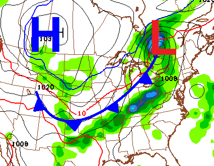 Showers and thunderstorms will be a good bet and we could see a few strong storms as the front pushes in. These kinds of fronts usually bring gusty winds as they blow through.
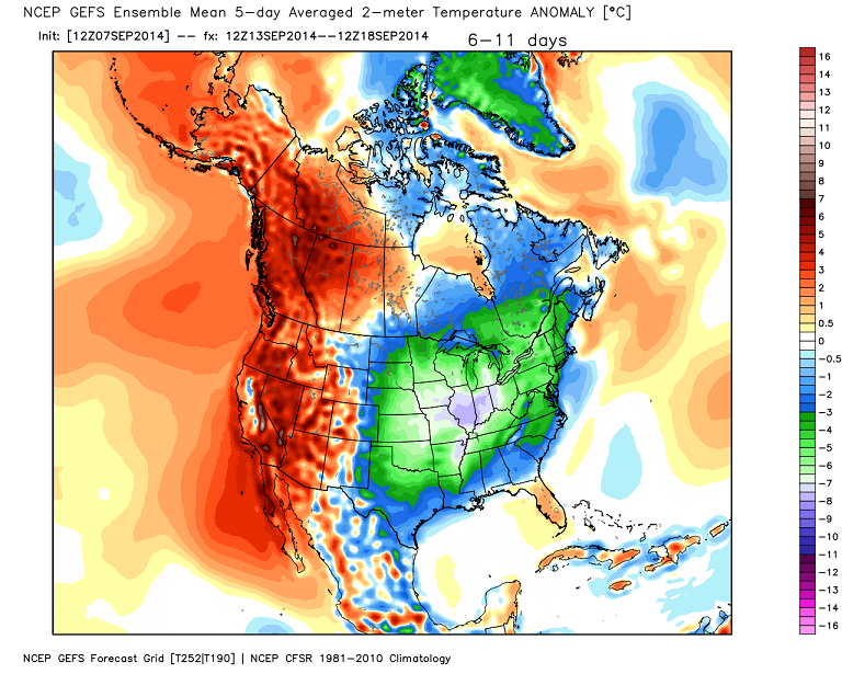
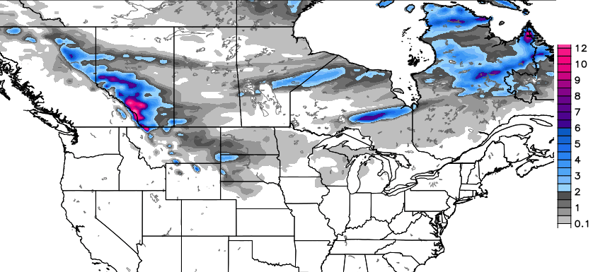
That system is likely to put down some snow across the Rockies into the northern plains. Check out the areas getting snow on the GFS over the next week…

Temps coming in behind the front will be well below normal for much of the country this week. The core of the cool works into our region by the weekend into next week…
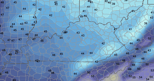
 Highs over the weekend will generally range from the mid 60s to low 70s across the state. Lows will hit the 40s and could drop toward the low 40s for some areas…
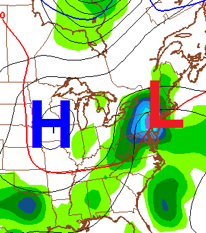
A reinforcing shot of cool air is likely to move in behind another storm system into the first part of next week…
 Again… I still don’t think this is a true start to full-time fall weather.
Make it a great day and take care.

Can someone post a link to Chris Bailey’s old blog if you know where it’s at?
You mean from the sojourn to WV?
http://www.wsaz.com/blogs/chrisbaileysblog
or if you’re talking the O.G. blog, then the Wayback Machine is always your friend…
http://web.archive.org/web/*/www.wkyt.com
I know it was there in Dec 2004, but I you’d have to dig yourself if it was hosted earlier in the timeline. Obviously, not all links will work in the ole WB Machine but many do.
Hey, if you happen to know of any area mets doing a Fall Forecast, please throw up a link.
Bring it on old man winter. Chris, could you clarify on the ENSO and what effect is will have on our weather. Based on model trends and current status, what does it mean for the coal fields of E SE KY?
now there will be a rush to the grocery stores for chili beans, ground beef and crackers. thanks a lot! STOCK UP NOW!!!!
Funny! I’m ready! So, do we all go to Bailey’s house and enjoy said chili. I’ll bring my own bowl and spoon.
Thanks Chris. This past weekend was decent, but Saturday was so humid it was nearly unbearable. Don’t know how the players did it. We were at the Lindsey Wilson game and there were several play stoppages for cramps. I know it sure was hot in the stands! Don’t mind a little bit of cooler air coming in. Really hope it stays warm in the south for a few more weeks though. Got a trip to the Sunshine
state planned first of October, and want good beach weather.
Well, it IS Monday, so everyone have a great day! Thanks again Chris for all you do. You are appreciated more than you know.
In addition to this weekend’s cool shot, one of the models is showing a system with tropical characteristics possibly strengthening while moving up the Atlantic coast by this time next week. If that holds true, we could see another shot of cool temperatures with raw east to northeast winds.
Thanks, Chris for the look ahead! Chili and football…..a great go together. Lookin forward to chili (chilly) in the hills. Hope it stays warm near the OBX for the end of this month. Like Coffeelady we have a trip planned. We can only hope….we’ll take what we can get.
Let’s use a game of Mondayto to settle whether the chili gets made.
One mondayto, two mondayto, three mondayto, four,
five mondayto, six mondayto, seven mondayto, more!
Hopefully, the models pan out and we get that level of a cool shot. Also, hopefully, the chili has beans and isn’t one of those Texas-style abominations that throw in heat to disguise the lack of taste.
Skyline Chili weekend either love it or you hate it. Personally I love it.
These storms just refuse to die. What’s the record for flash flood warnings over a 30 day period? Goodness gracious.