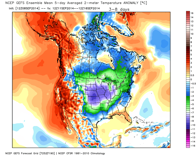
Good Tuesday, everyone. September is a month of change as we make the transition from summer into fall. Change is exactly what we have rolling our way in the coming days as the first real fall cold front arrives. That brings the threat for booming storms and the coolest air since spring.
The weather out there today will be a little warmer than the niceness of the past few days. Highs will hit the upper 70s to low 80s for many areas. I can’t rule out a few showers or thunderstorms, but most look to stay dry. Any storm that goes up is more likely in the east and southeast and could contain heavy rain. Stop me if you’ve head that one before.
Current Temperatures


Our cold front begins to work our way by Wednesday night and Thursday. It’s likely to spawn severe weather to our north and west on Wednesday and we will need to keep a close eye on that. We could get a squall line of thunderstorms rolling in at some point.
The actual front blows through later Thursday…
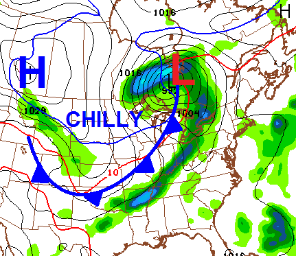
Temps behind this front will tumble with upper 60s to low 70s for highs on Friday. A weak disturbance could bring a shower or two our way on Saturday. If we get some clouds and shower… high temps could be even cooler than the upper 60s I’m looking at.
Upper 60s to low 70s look common Sunday and Monday. Any clear night will see temps bottom out in the low to middle 40s.
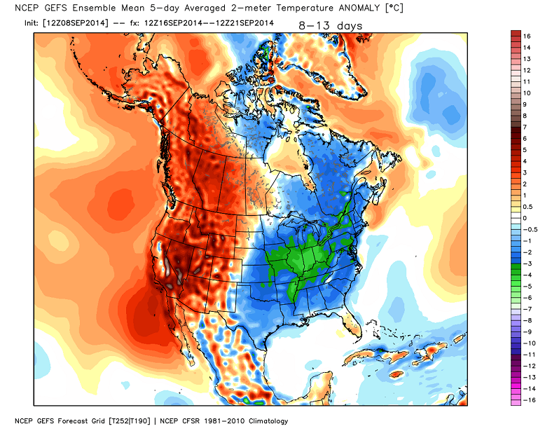
This is a very cool pattern for much of the country that hangs tough through next week…
 Make it a great day and take care.

A pup enjoying her first snow in Calgary yesterday. Let the Canadian snow pack continue to accumulate!
http://i.imgur.com/vDwhDT0.jpg
So where are we on the Pot O’Chilli alert scale??
Cooler weather…YES! Some breezes bringing some fall weather sounds great, just not quite ready to talk about snow. Chili around a fire pit or at a football tailgate is just the kind of weather I hope we have on the way.
Thanks Chris. Boy you are just full of good news, aren’t you? Seriously, I don’t mind cooler weather, but I am just not ready to give up on the warm weather of summer just yet. I look forward to fall, but I guess I hope it doesn’t kick in until we get back from vacation. Then it can be fall all it wants to! Looks like a perfect early fall evening for football on Saturday night, though. So that is a big positive! Hope everyone has had a wonderful day! Thanks again Chris, for all you do.