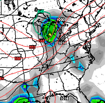
Good Wednesday, everyone. A powerhouse of a cold front is rolling toward the bluegrass state and will bring a huge change to our weather. A blast of fall air is on tap for late for the weekend into much of next week. Things may get a little bumpy ahead of the front as storms rumble through the region.
Winds will crank and temps will soar into the 80s today. We could see a stray shower or thunderstorm going up, but most of the action will hold off until later tonight and Thursday. This is when a squall line of thunderstorms works in from the northwest. The highest threat for severe weather is just to our west and north, but we need to keep a watch on that setup. Showers and storms will continue into Thursday with the potential for some heavy rain numbers.
Track away…


Today’s risk area

Current watches

Possible watch areas 

A cooler wind will blow behind the front from west to east late Thursday. That sets the stage for a cooler Friday with a mix of sun and clouds.
We’ve touched on the chill down for the weekend and I have no changes in that. Highs will range from the upper 60s to low 70s with lows dropping into the 40s.
I’ve also touched on the chance for showers and I’m trying to time these threats a little better. The first one arrives on Saturday…
 The next system may have a little more juice with it as it arrives early next week…

Overall, this is a fall pattern settling in and it’s one that’s a few weeks ahead of schedule.
Some winter talk is on the way with tomorrow’s post. Spread the word.
Enjoy your day and take care.

Thanks CB. I read an article a couple of days ago that was calling for record snowfall in our area this winter. Any truth to that Mr Bailey? Thanks for all you do sir.
If you’re talking about the article from “Empire News”(http://empirenews.net/meteorologists-predict-record-shattering-snowfalls-coming-soon-bread-milk-prices-expected-to-soar/), it’s been making the rounds on social media and it’s fake.
http://www.baltimoresun.com/news/weather/weather-blog/bal-wx-popular-map-suggesting-recordshattering-snowfall-is-a-hoax-20140909,0,6792902.story
Thanks Chris. Wearing my shorts to work today as it looks like it’s back to pants tomorrow. Beautiful morning here in Simerset. Have a great Wednesdsy everyone.
FINALLY!!!:) I have been waiting and waiting for some “winter talk”! CB you are the best…Thank you!
Thanks CB for keeping us informed. Hopefully the severe threat will fizzle a bit by the time the storms get to our area overnight, although still looks like some threat for strong damaging winds and some isolated flooding.
Interesting link (click link here) by NWS Morristown TN. Although the article is about a rare July twister outbreak that happened this year, the article could also pertain to the months of August and September on how relatively rare tornadoes are in our area during the summer months.
Besides the main tornado season during the spring, our area does have a secondary twister season coming up which peaks in November. But at least for the system coming in overnight, the tornado threat appears to be low at this time.
http://youtu.be/js2wh9saLZk
Brace yourselves for winter talk and all the pontificating that comes with it. 😉
“Trend is your friend” will be stated many times.
Lookin forward to that winter forecast. Thanks Chris!
I am looking forward to it also. I miss Farmer’s Almanac’s blog. 🙁