Good Monday, everyone. A lot of people complain that fall is just too short around this part of the world. Well, mother nature may be trying to lengthen the season this year. We have additional shots of cool air on tap this week. I break those down and take a look at where some things stand as we head deeper into fall and winter.
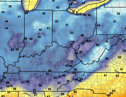
Today will be the mildest day of the week with temps in the 70s and winds picking up a bit. You will notice some clouds rolling in late in the day from west to east. Those clouds are ahead of a cold front that moves through overnight into early Tuesday. That front can spit out a few showers.
Highs Tuesday will be back in the upper 60s for many areas as cooler winds blow in. That should set the stage for another night of 40s for lows…
 The cool air continues to funnel into the region from the north and even northeast. This is when a huge blast of chill moves across the Great Lakes into the northeast…
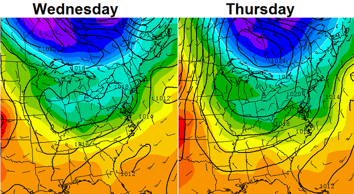 Those setups can feature sneaky cold that the models don’t really pick up on. Heck, the models were awful with our weekend temps. That’s why I tell young forecasters to stop regurgitation what a model says. Look at actual weather maps and what the weather is doing verses what the models say. End of mini-rant. 🙂
Temps should rebound some by next weekend as more normal air moves in. There is now some indication of another cool shot coming down the pike early next week.
Let’s talk a little fall and winter.
I keep talking and talking about how the overall weather pattern in North America hasn’t really changed much since last fall. That’s when I started picking up on this big warm pool of water of water off the west coast into the Gulf Of Alaska. That forced a huge ridge of high pressure up the west coast into Alaska.
Guess what? That warm pool is still going strong and is forecast to remain there through the upcoming winter…
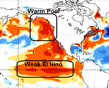 Throw in a developing weak El Nino and you have the potential for some serious winter weather across the country again this year.
This is also the time of year I start watching the developing snow pack across the northern hemisphere. It’s still very, very early in that game, but it’s above normal for this time of year. This map shows the areas that usually don’t have snow on the ground right now…
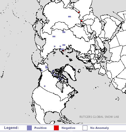 We will have to wait and see how this progresses through October. That’s the month that really matters in the overall development of the snow pack.
Have a great Monday and take care.

I’ve read that the current pattern follows the analog years of 09-10 and 77-78. Could be in for a crazy winter.
’77-’78?! Eeeek! Best ever winter for snow lovers in my lifetime! Bring it on!
Thanks Chris. Looks like a decent week overall. We are getting into the period now where we have the cool nights and warm days. Won’t be long until the leaves start to change. Summer has been awfully short this year. Have a great Monday everyone. I gotta go to work.
Not a bad day at all.Somewhat overcast but that kept our temps in the low to mid 70s all day.Really liking the 60s/40s forecast.Sounds as if we may be looking at a repeat of last winter but maybe more precipitation.For now I am in the mindset to prepare as if I could be stuck on this hill for a month.Better safe than sorry and if it don’t get that bad everything will still be used anyway.
Thanks Chris for the outlooks.It is really helpful to the ones of us that have to prepare in advance due to our locations.
So much for a few showers here in Woodford County. It is pouring!
I know……I had to sleep all day today and just got up an hour ago, and I hear rain pouring and I’m thinking WTH?