Good Tuesday, everyone. I said last week that I didn’t think this was a true start to fall here in Kentucky. Mother nature is trying to make a liar out of me (like that would be the first time). Additional shots of chill look to carry us through most of the rest of September.
We do have a cold front on the move across the state today. This is bringing a scattering of showers to the region and is ushering in a reinforcing shot of cool temps. Temps today are going to struggle into the mid and upper 60s for highs into central and eastern Kentucky. Upper 60s to low 70s will be around for the rest of the area.
Current Temperatures


The weather from Wednesday through Friday looks awesome! Highs will range from the upper 60s to low 70s with overnight temps dropping into the 40s. Watch for some foggy mornings.
Saturday looks windy and warmer with temps well into the 70s. Take advantage of that because another cold front arrives Sunday with showers and some thunder. This carries us into Monday as temps take a dive behind the front. The European Model is going crazy with the cold coming in behind this system…
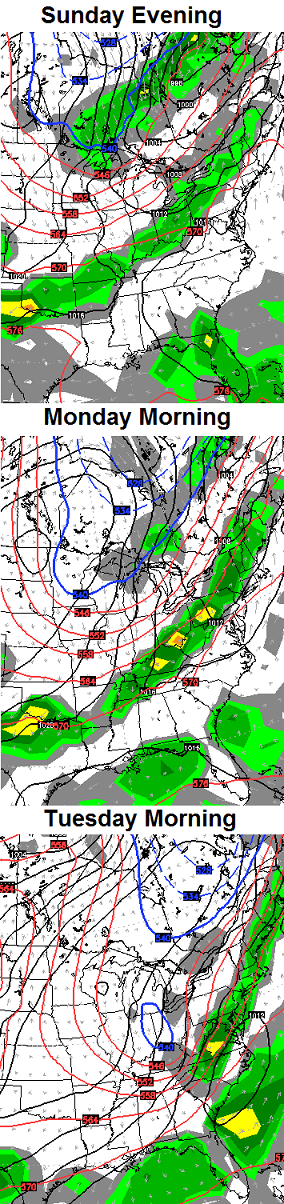 That particular model run takes temps into the “crazy below normal” temperature category…
 I suspect the European Model is overdoing the extent of the cold, but the pattern does favor another run of colder than normal temperatures.
Enjoy your extended fall weather and take care.

Hey I like the fall weather. And think nothing of it, mr Bailey. Every good weather dude is going to get Mother Nature’s curve ball now and then.
About as good as it can get.
I had a great time with the kids yesterday taking pictures of fall leaves around the neighborhood. This is a great time of year. It would be ok with me if the record cold and snows started early, but let’s wait at least 6 more weeks. Have a great day everyone!
I’ll take this weather until about December 1st then bring in the Snow and cold!
Happy Birthday CB!
Thank you!
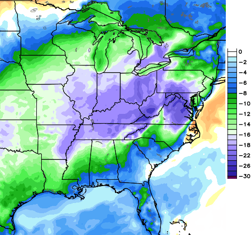
CPC now says there is a 40-50 percent chance that the rest of the month will feature below normal temperatures…
Good day to make some pumpkin spice cookies, so I did. Weather was cool enough outside that the extra heat from the oven felt pretty nice. Low 60s all day and overcast with off & on mist. Maybe our leaves will start to turn soon, but so far they haven’t, except in the Carter Caves area. Sure looking forward to those bright colors.
For the first time this season, had the wonderful smell of firewood in the air a few nights ago. It was about 9 pm and it was not all that chilly at the time (although Nashville did eventually drop to 55), but seems somebody could not wait to start off fall 😉 .
My parents were never big about using fireplaces, although I’m wanting to give my fireplace a try before long.
But one time the old family fireplace really came in handy was in the aftermath of the Blizzard of 93. I was nine at the time, and the lives of all family members – and pets – revolved around the fireplace for a couple of days until the power was finally restored.
Yes, yes I will very much enjoy an extended period of this perfect fall weather. Cool temps, fog, misty rain, a cold breeze…. I could go on and on and on…