Good Thursday, everyone. The weather is so nice that your friendly weatherdude is having a hard time staying focused. So, this update is likely to have a whole lot of randomness to it. Let’s call it free styling! 🙂
The weather in the short term continues to about as nice as it gets with upper 60s to low 70s out there today under a mostly sunny sky. The weekend starts with low and mid 70s for Friday with mid and upper 70s to near 80 on Saturday. Winds will gust up with a cold front arriving on Sunday. That leads to scattered showers and thunderstorms going up.
The air behind this continues to look chilly for next week. The GFS Ensemble Mean shows the temperature anomalies in Celsius for the 5 day period…
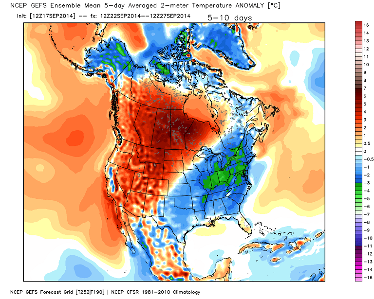
How cold that air actually gets around here still depends a lot on what happens with the leftovers from the Pacific hurricane across the west and plains. Also, keep a close eye on a possible storm developing off the Carolina coast.
Speaking of the GFS Ensembles, check out the “best match years” for our end of September setup…
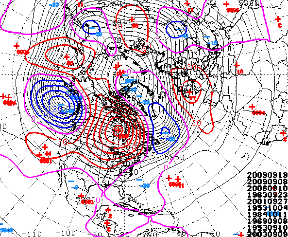
2009 takes the top two spots and that’s a year I have been looking at for the winter ahead. You will also find the bitter winters of 1963 and 1969 on that list. There are 4 years on that list I am looking at for the fall and winter ahead of us. Any guesses on which 4? I already gave ya one!
Maybe I should just scrap looking at past years and go with the two main Almanacs forecast…
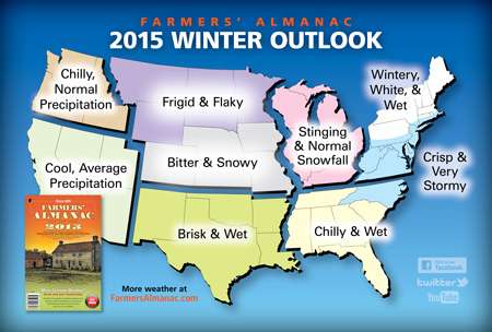
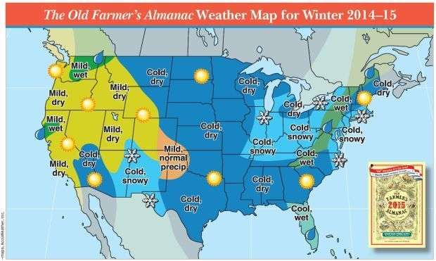 Hmmm… that would be a lot less stressful and less time consuming for me to do. But, I think I will keep doing my normal thing.
Make it a great day and take care.

Models flip floppin’ all over the place on next week’s pattern! I like CB’s forecast because he analyzes the data and never jumps straight to conclusions. Still very low confidence on the strength of next week’s chilly air so we’ll have to play the wait and see game. Have a gorgeous Friday’s eve!
Feels great outside! Much better than upper 90s and 100s like in California on my vacation lol. 😉
Some of us we’re enduring those number here too…only on a golf course.
1969 is my guess
You said 4 years I would say 1984, 1969, 1963 & 1953
Looking at the anamolies map (departure from normal) I have continually this summer seen how the US and Canadian plains and Rockes all the way up to Alaska has continued to be warmer than normal. In my limited weather thinking, it seems that with the warmer temps would cut down on the snow pack, and thus cutting our winter weather and cold chances. I don’t remember noticing that trend last winter though…either I didnt’ notice it because I was too focused on our neck of the woods or the warmer than normal temps werent there. Anybody have any expanded thoughts on this…other than “there are too many variables to answer..”
Typically and general rule of thumb when Alaska is warmer (or has a warmer winter) the eastern half of the US is colder. Last year was case in point there were times last winter where Fairbanks Alaska was warmer than northern Florida. Kinks in the jet stream or strong high pressures over the western hemisphere will cause places like Alaska to get the warmer Pacific air. It also keeps the eastern US quite cold as the northern jet plummets much further south than usual. The west will be under a strong ridge of high pressure while the east gets locked in to cold and sometimes stormy patterns.
I’m liking the telecom signals at the moment. A weak nino/+PDO, cool summer (not like this is a real strong factor), promising ice content, etc. However, I think this winter, as the case with most winters, will ride on the NAO/AO. It will make the difference b/t 2004-05 and say…2009-10. Granted, most KY locations cashed in on the 12/22/2004 snow during what was a relatively mild winter that year. But at least a couple favorable ingredients are on the table. At any rate, I just hope my Nashville homies can cash in after getting the shaft three straight years…
I’m going to guess 2003 is one of them.
It’s a bit confusing, the GFS matches. Is that saying it matches sept of 2009, which would mean winter of 09-10? Because the big ice storm was in january of 2009, not the end of 2009. Same thing for 2003 on the bottom. Is that 03-04 winter? None of those winters were that significant as far as I remember.
The year shown leads into the winter ahead. 2009 would lead up to the winter of 09/10 and so forth. If you’re a fan of cold and snow, you love seeing 2009, 1963 and 1969 on that list.
Thanks Chris. IF I were guessing, I would guess 1969, 1976 1963 and can’t decide about the fourth. I am enjoying the weather but still not ready to let go of the warmer weather just yet. Although warmer weather seems to be the abnormality. Not been that hot, for most of the summer, for sure. Anyway, I am going to enjoy each day as it comes, whatever it brings. Have a wonderful Friday Eve everyone!
I’m surprised I don’t see a 1987 analog. I recall temperatures similar to what we have been experiencing lately. Then a brief shot of very warm air preceded a potent cold front that welcomed the first several days of October with very cool/cold air, so much so that October finished 6th coldest at Louisville and Lexington.
Believe it or not August 2014 will go down as the hottest month ever recorded globally beating out the old record August of 1998 pretty impressive considering records have been kept since 1880. Ironically the US was one of the coolest spots globally last month.
I already staked out October 13th months ago as the first measurable snowfall for Madison Co., given it was around the 21st last year.
If a certain local met would like to start a First Snowfall bet for charity, I’m sure it would raise a nice amount of money. Hmm, maybe $20 for anyone to enter and pick your day? It seems like something like that would be a nice way to start a fun tradition going forward.
Keep the snow ideas coming!
I’m predicting a lot of snow forecast……and little actually occuring as usual. If I m wrong I ll let you all sponsor me a trip to the Bahamas this winter……..I M WILLING TO DO THAT!