Good Wednesday, everyone. Wow. That’s about all I can say about the weather around here Tuesday. Rounds of strong and severe thunderstorms pounded the state with large hail, damaging winds and a few tornadoes. That goes down as one of the busiest days I’ve had on the TV Side of things.
Thankfully, things are much calmer out there today. Don’t get spoiled by it as rounds of rain and storms look to become common from later this week through the weekend and into next week.
Today will find a partly sunny sky with pleasant temps ranging from the mid 60s in the north to around 70 south.
Clouds will quickly return later tonight and that sets the stage for showers and scattered thunderstorms to return from west to east on Thursday. The setup remains the same with a stalled out frontal boundary with ripples of low pressure moving along it. This leads to showers and storms through the upcoming weekend. Heavy rain amounts are likely during this time.
Temps will range vary depending on the exact placement of the front on any given day. Areas to the north of the front may have a few days in the 50s with a big temp swing setting up from north to south.
Another potent storm is likely to develop across the plains and roll into the region early next week. Check out the European Model…
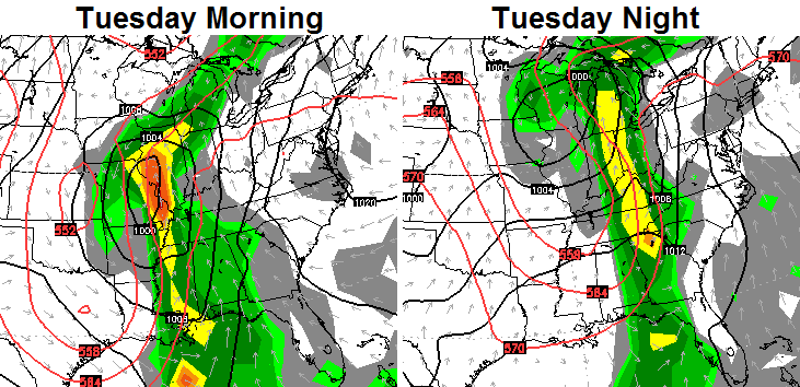
If that verifies… severe storms and heavy rains would be possible once again.
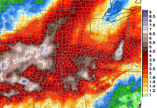
The rainfall numbers from the European Model continue to run on the hefty side for Kentucky and surrounding areas. Take a look at the numbers…
 As I said… enjoy today’s dry weather and take care.

Excellent job last night Chris. You made the other local channels look like amateur hour. Congrats and THANKS to the entire weather team at KYT!.
Thank you, Scott! Much appreciated.
Chris, we are in sunny Daytona Beach but kept up with your coverage via Twitter last night. Thanks for keepng everyone up to date on a dangerous situation. I knew when to worry about my hous and kids! A big thanks to everyone on the KYT team! Have a great day, everyone!
I m trying to find out about the situation where Chris and Jim were talking about the radar showing the debris ball last night. Where did it hit and what kind of damage was there? Does anybody know?
There may be some information you want on Chris’s Twitter page.
http://twitter.com/Kentuckyweather
I really hate to see damage.We had a lot of rain and some wind but nothing damaged.Nice to see the sunshine today but that is probably only going to last for today.
Thanks for all the updates and information that was posted quickly yesterday.Those photos of hail on the roadway were wild.
When is this rain gonna end?when are we gonna have at least one week of dry weather? I don’t like bein stuck indoors.
We just had three weeks of dry weather in Sept..
Lol some people are never happy
5 hours of weather 3 channels to much over and over. How about keeping your jackets on and going home. Run it at the bottom for the love of TV. I moved to the History channel soory good stuff but to much!!!!!!!!!!!!!!!
6 confirmed tornadoes and counting say you are dead wrong.
Wow so much hating. People’s lives were at stake, thanks to the coverage no one died last night. Think before you speak.
Unfortunately, three fatalities from an automobile crash near Stamping Ground KY are now being treated as weather deaths. The NWS confirmed an EF1 tornado near Stamping Ground. But regardless of whether the crash was due to the tornado or some other bad wx, lives were indeed at stake as Lori touched on.
Mike,a lot of people need the information.When there is bad weather to much information is way better than not enough.I don’t know if there is such thing as to many alerts and updates especially when there are possible tornadoes at any time.
There are still a lot of people that don’t stay plastered to the internet and only have TV to get these alerts.A lot of older people don’t even go online.I suppose its bit more urgent to the ones that are in the Bulls-eye but I think we really need to appreciate the weather people that will devote this much time and effort to protect the people in their viewing area.I will never forget how thankful I was for every one of them during the 2012 tornadoes.
Its a bit like this blog,we can check the weather many places but no one else takes the time to give us in depth details and the whens,wheres,and whys of it all.Maintaining this blog takes time and effort that is done for viewers.
I don’t know,maybe its like that saying,no good deed goes unpunished.. [:{]
I too rely on this blog. It is the only weather resource I use. Chris, thanks to you and your weather team. You are the best and I for one am grateful to have you. Keep up the good work.
I’ve got a buddy who’s an expert in Weather TV Scroll Feeds…okay, looks like the best I can offer you is about treefiddy.
Seriously, there is absolutely nothing on the main History Channel that could possibly be more interesting than weather updates by CB or by anyone.
I lol’d at the “dead wrong” until I saw further down that people had actually died. Ugh, awkward. May want to ninja edit that one out.
I didn’t watch the coverage, but for crisis coverage I give credit where it’s due, as CB is the man when it comes to crunch time.
I wonder if we’re on pace for a top 10 wettest October?
Thank you Chris, for staying with us last night.
You’re welcome!
Chris thanks for everything you did last night since the tornado in west liberty I am scared to death of storms wkyt is so lucky to have you as so are we and your blog I just ont know what we would do without you
I am the same way.I could see the one that hit East Bernstadt from my house still in the sky before it touched down.I would not have even been looking if not for the alerts.At that point we thought the storms were over for the day and then there it was.Then the sirens started..A day I hope no one has to ever live through again.
Do any of the analog years for winter you’re looking at feature severe outbreaks in October?
Yep… 2002 and 2009.