Good Thursday, everyone. Rounds of showers and thunderstorms are taking aim at the bluegrass state as we go into an extended period of soggy weather. All signs continue to point toward several inches of rain falling over the next week. That could lead to high water issues.
Scattered showers and storms continue to push into the region from west to east today. This action will increase later this evening into tonight when heavy rain becomes more of an issue.
The stalled out front will hang tough on top of the region through the weekend as waves of low pressure work along the boundary. That leads to a weekend washout…
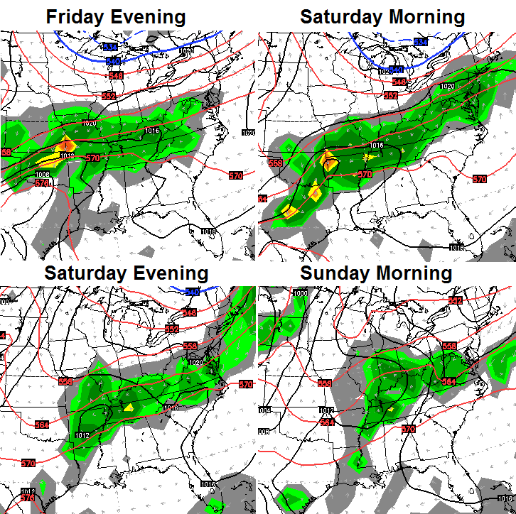 The models then continue to key on a stronger system moving in early next week. The European Model is cutting this thing off right on top of Kentucky…
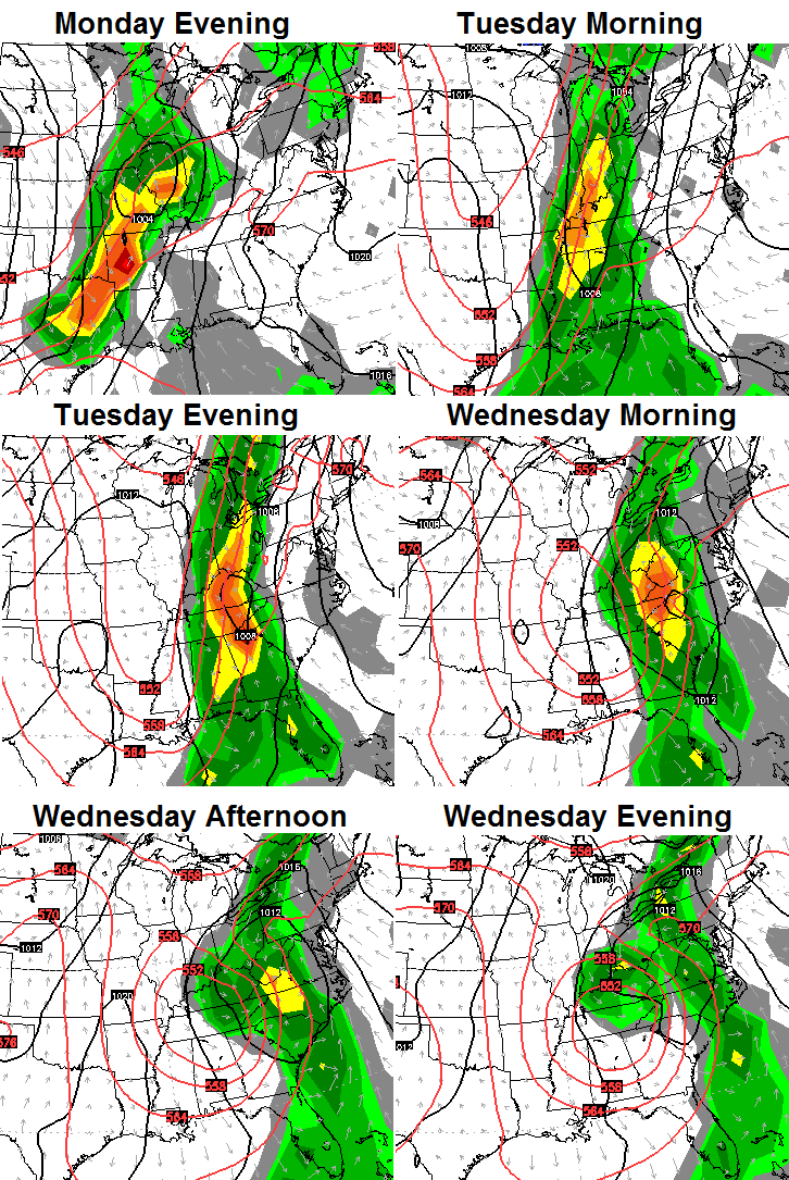 Strong storms will be possible ahead of that system with torrential rainfall possible as the system slows down. The rainfall numbers from that same computer model are crazy…

That would lead to an increase in the flooding threat. Again… that’s not all coming at one time, but over the next week.
Let’s track today’s rain into town…

Have a great day and take care.

I do not recall seeing such impressive rainfall forecasts from the NWS Louisville now at 4-6″ over the next several days. WPC QPF forecast shows at least 4″ for central KY and up to 6″ across western KY. Could be another top ten wettest month for at least one of the Autumn months of September through November here in Louisville, making it 11 of the last 14 years.
I think since moving here in 1996, a FEW of the years since then have been top ten wettest.
I have a Saturday morning flight from LEX. Does a delay seem likely?
If it were cold, could you imagine the amount of snow! That would be awesome!
Forget about it, that would amount to a widespread 70″+ and local amounts reaching 90″ for the next week!
Rolo would have a stroke at such a thought. 😉
Looks like lots of rain coming is there
any signs of cold air moving in behind it?
Very impressive AO for October at or a little above -4.00…Wonder how this correlates with winter past’s with such high negative values for Oct????…Fun times ahead maybe eh…….
That’s a VERY strong indication of blocking for the upcoming winter months. There’s a strong correlation to October blocking and the following winter.
CB, with 9 confirmed tornados statewide would this be considered a tornado outbreak? If not what is the qualifications of a severe weather outbreak?
tornado outbreak = April 3, 1974
Im seeing I should of rephrased this question. Is 9 confirmed tornado’s statewide consider a outbreak of severe weather?
Now that I just read what I wrote it seems I’ve have asked the same question twice. On that note I shall quit writing for today. Good day! lol
Hi Prelude. Your question was, in fact, a good one. I would be interested in hearing CB’s thoughts. I was a student at Georgetown College that awful April night in 1974. We evacuated out of dorm rooms into a field on campus. I remember seeing at least one funnel cloud fly over in the darkness. Of Course nearby Stamping Ground was devastated. At daybreak, several of my fellow football player team mates drove to Stampiing Ground to help with the cleanup. It was quite a site. I might have mentioned before that I found an old 45 record laying on the ground and picked it up. Amidst the destruction and death of the day, I was taken aback by the complete irony of the record’s title…it was Donna Fargo singing ‘I’m the Happiest Girl in the Whole USA”. The record still hangs in my home office as a reminder.
Yes, this is a tornado outbreak. One could even call this a tornado “swarm” since so many were concentrated in a central location.
Yes, April 3 1974 had nearly 150 tornadoes across the eastern US and Canada with a relatively high percentage of F4s/F5s; over 300 fatalities (including about 71 in Kentucky [31 in and near Brandenburg alone] and about 44 in Tennessee).
Thankfully, last Tuesday had only EF0s/EF1s.
Early rainfall leaders coming in from near Elkton in Todd County and Russellville in Logan County at 1.34″ and 1.31″ respectively since midnight.
Looking like a broken line of strong/severe storms forming from near Nashville northward into KY. Will this be continuing in coverage tonight?