Good Friday and welcome to the weekend. We have a pretty nice weather weekend kicking off here in the bluegrass state. Temps will take a walk on the mild side with mainly dry conditions. Enjoy it, because several systems look to bring some big changes as we head into Halloween week.
There is a very weak system pushing across our region today. This is spitting out some clouds and there is a small threat for a few sprinkles or a light shower.
Current temperatures


Temps should warm toward 70 if not a little higher on Saturday. Winds will become gusty from the southwest and could reach 25mph at times. Those winds area ahead of a weak cold front that sweeps in later in the day. While it looks dry, I wouldn’t be totally surprised to see a stray shower on radar.
Sunday looks equally as nice with slightly cooler air in the central and east. Enjoy this weekend!
Changes show up by Tuesday as a strong cold front pushes in from the northwest. That will bring gusty showers and storms that hang around into early Wednesday…
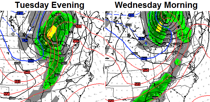
Temps will come tumbling down with readings in 50s for highs by the middle of the week. What happens after this continues to be the weather question of the moment. The GFS has been advertising a taste of winter weather across the eastern half of the country for Halloween weekend. Other models, like the European Ensembles, joined the mix…
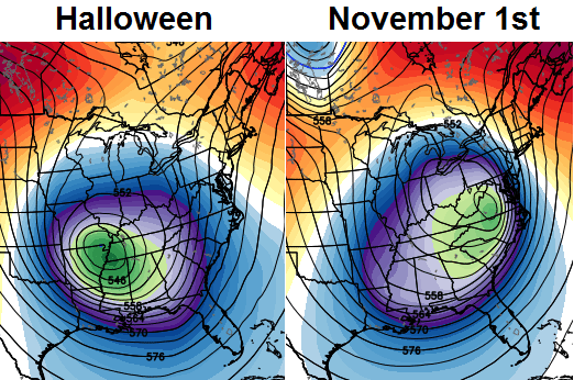
What does the GFS do once it gets friends to play with? It takes its ball and goes home. The overnight run of the model totally abandoned the cold weather idea. The European Model held serve with it…
That’s still a week away and we have a lot of time to figure out this plays out. The models are not getting the normal amount of data ingested into them, so some wild swings are likely until that problem is resolved.
I will have another update later this evening, so check back. Make it a good one and take care.

Thanks Chris. Just going to get out and enjoy what we have! Have a great Friday everyone!
Yep, the models will be all over the place from now until April …
Snow possible for Halloween anyone else heard this?