Good Tuesday afternoon, gang. It continues to look more and more like a blast of winter weather comes screaming into town just in time for Halloween. The models are doing what we said would happen several days ago… trend back to what they were showing from a week away.
The GFS now matches the European Model in showing the potent upper level system diving right on top of us Friday and Saturday…
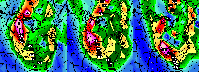 If the models are accurate with the intensity and track of that system… it could be pretty wild around here. That would create a tremendous amount of wind and crashing temperatures to go along with rain and some snow. I’ve even seen similar situations produce thunder and lightning.
The GFS shows no shortage of precipitation across the region…
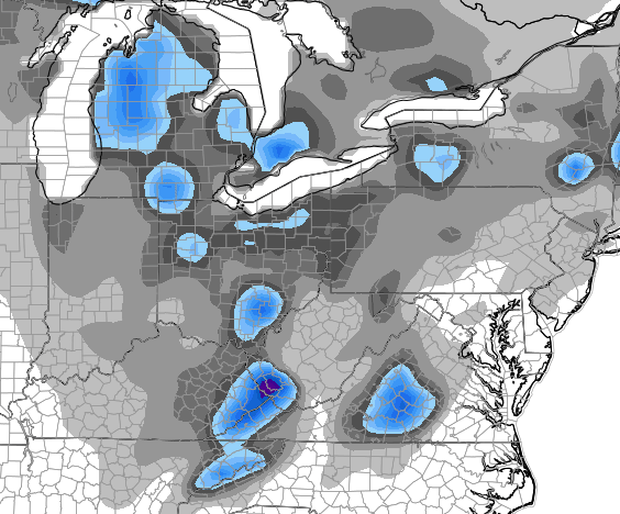
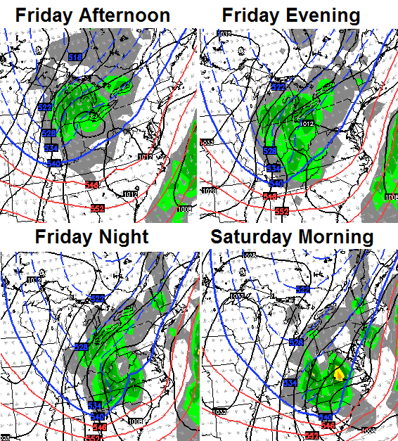 IF things work out like that run suggests… rain would mix with and change to snow in many areas Friday evening into Saturday morning. The models continue to target the mountains of southeastern Kentucky with the best chance at seeing flakes and some accumulations…
 None of this is set in stone by any means, but my confidence in a taste of winter is increasing. Odds favor the first flakes of the season, at least, falling in our region Friday night and Saturday morning. Can it turn into something a little more? That’s possible and something for us to continue to track in the coming days.
I will get another update out later today and be back on WKYT-TV starting at 4.
Take care.

Wow! Going from summer to fall to winter inside of a week! One thing is for sure…. The weather in Kentucky is never boring and Kentucky Weather Center is on top of it! Thanks Chris.
I remember back in the early 1990s, we had an accumulating snow above certain elevations on Halloween night. I was working at the newspaper in Estill County at the time. We got a photo of some of the mountains there, still showing their fall colors, with a very distinct snow line. It was one of the most popular photos we ever had. We sold out of papers that week in large part because of that picture.
I remember that Halloween, I spent the night with my on Barnes Mt., and early the next morning she woke me to show me something and the snow was beautiful.
daughter.
All I can say is , it will be beautiful with all the pretty colors and snow laying on the trees.
Thanks Chris.
I told u all SNOW before oct ended!!!!!!!!!!!!!!!weeeeeeeeeeeeeeeeeeeeeee
You didn’t tell anyone jack. Step away from the moonshine.
He did actually, troll.
I’m not a troll, genius.
Yes, yes you did Rolo Rollo! Now you have to verify with the rest of the winter predictions…take care and watch that hood rat.
I was always told that the date of the first snow indicated the number of snows you would get in the winter, haha. So if it can pull some flakes on the 31 that would be a good sign for winter lovers.
As for the rain to snow that would be crazy if the temps dropped to the mid-20s. Wondering if any of that rain freezes to the trees and allows the snow to stick. Could make a very nice looking scene early Saturday. Might have to get up at daybreak and get some shots.
The cold front is indeed arriving. Still 74 in Nashville but already down to 58 just up the road in Clarksville TN.