Good Wednesday, everyone. If you’re a regular reader of the blog, you’ve probably picked up on some of my posting tendencies. When I’m seeing something that’s really getting my attention, I fire off multiple updates a day. I’ve been doing just that over the past several days because of what looks to be a blast of winter coming for Halloween weekend.
As a matter of fact, this is a pretty extreme setup showing up on the models. It’s one that should put snow in the air and has the POTENTIAL to put snow on the ground for some.
Every single model out there is forecasting the first flakes of the season for Halloween into Saturday. Some show just a taste of winter while others show out and out winter. The GFS is one of the models going all in on winter weather. Take a look at the progression from Friday afternoon through Saturday afternoon…
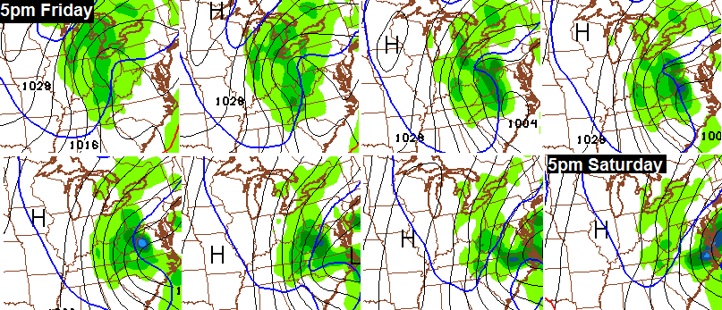
That’s a much colder solution that makes a switch from rain to snow from west to east Friday afternoon and evening as cold air crashes in.
Here are some early thoughts on what the models suggest will happen:
– Friday starts with showers around with temps in the 40s to near 50 through midday. Cold air then crashes in as the arctic front swings through. There’s a chance many areas reach the 30s before dark.
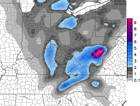
– Rain and snow will be around for Halloween with the possibility of this becoming all snow. If the models are correct, some bands of heavier snow would be possible through Saturday morning. The best chance would be in central and eastern Kentucky. The NAM also shows that potential very well…

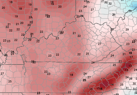
– Winds will really crank later Friday through Saturday. Gusts of 30mph+ will be possible. Combine those winds with the cold air and you could get late Friday evening wind chills like this from the GFS…
– High temps for Saturday may not get out of the 30s across parts of central and eastern Kentucky as gusty winds continue to make it feel much colder.
– What are the models saying about the POTENTIAL for some of the snows to stick? Both the NAM and GFS do suggest the possibility of that happening…
NAM

GFS
Let me be perfectly clear on something… those are snapshots of the model forecasts and NOT what I am forecasting. The models will vary from run to run and we still have a couple of days to see exactly how this thing plays out.. If I feel like accumulations are a real possibility, I will issue a First Call For Snowfall at some point. I am not to that point… yet.
That said, I do think the first flakes of the season will fly for much of this region.
Updates will come your way throughout the day. Make it a good one and take care.

WOW, from 80s to a chance of snow on the ground, this winter might get going early again this year!
Wow, I hope that doesn’t play out. I’m driving from Barbourville to Lexington Saturday for the Garth Brooks concert.
First flakes of the season flying on Halloween? I’ll take it!
Does anyone know when the last time was we were seriously discussing the possibility of flakes in October? It seems like it’s been forever. Maybe this is a good sign of us having a white Winter here in Kentucky? I mean, I can dream… can’t I?
Ummmm… Last year I think?
Yeah, last year. Seems to happen often.
I love this time of year, Chris, when I get to read your multiple updates every day. I look forward to hearing your thoughts on upcoming weather, especially snow. Thanks for all you do for us weather wienies!
What about Sunday? I’ll be on the racetrack down in Bowling Green Corvette Museum and am hoping for at least sunny.
Well, so much for seeing the little kids all showing off their cute costumes. They are going to have to be wearing their heavy winter coats for trick or treating, sigh.
Nothing say Halloween better than a ghost in a wool coat!
test
The POSSIBILITY of a “BREAD & MILK” alert in October…….WOW
Got close to an inch of rain.A very cool rain.So far we have made it to 51 today and the sunshine is trying to peek through at times.
I think we had weather something like this last year.Don’t recall if snow was forecast but I think we had some sleet and howling winds.They postponed Halloween locally until the next day due to the weather.
I will be glad when we have temps that are more stable.This 80s on Monday and 20s by Friday night is just a bit extreme for me.
Thanks Chris for the frequent updates.I like being able to see new updates more often.With the holidays just around the corner and the frequent weather changes this really is an exciting time of the year.