Good Thursday, everyone. Our first taste of winter is about to blow into the bluegrass state… just in time for Halloween. Rain, snow, gusty winds and December-like temperatures will be with us as we close our October and say hello to November.
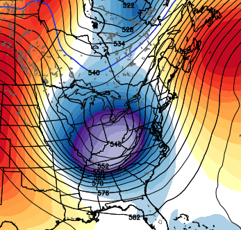
I continue to be impressed by the upper level system dropping in Friday into Saturday. I’m not sure I’ve ever seen a system that originated in the arctic take a path from the Great Lakes to Myrtle Beach (certainly not this time of year)…

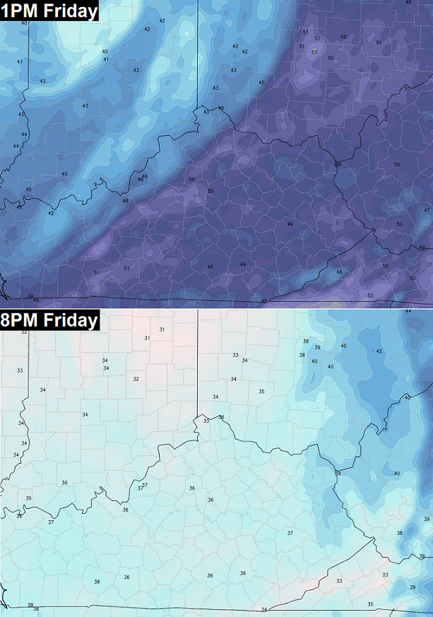
That’s a very dynamic system that will provide the atmosphere with a ton of rising air and wild weather. Temps just ahead of this will spike toward 50 early Friday afternoon. The cold air will then sweep in here with a 10-20 degree drop in just a matter of hours. Temps in the 30s are likely for many of the kids making their candy rounds…
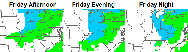
Winds will really increase as that arctic front slams through here. Showers will be likely along and directly behind this front with some thunder possible.
The temp drop will occur from the top down and that means we can get a touch of sleet or graupel with surface temps as high as the low 40s. As those temps drop into the 30s, snowflakes will begin to show up…
Here’s a little better depiction of the Halloween evening map from the GFS…

We will need to pay attention to that band of snow showing up from Lake Michigan into Indiana. That rotates in here Friday night and could cause some minor accumulations. A lot of the snow that falls will melt because of the mild ground temperatures. Anything that sticks would be mainly on grassy areas and elevated surfaces. The best chance still appears to be in the high elevations across southeastern Kentucky. Those folks could see some out and out snow accumulations…
 As you can see, there’s no reason to stock up on bread and milk… well, unless you’re out of both. 🙂
Temps continue to look very cold with readings by Saturday morning in the upper 20s to around 30. Gusty winds will make it feel closer to 20. Highs Saturday will range from the upper 30s to low 40s with some leftover flakes into the afternoon in the east.
Next week will feature another system bringing chilly showers late Tuesday into Wednesday with the potential for another big buckle in the jet stream by the end of the week…
I will have updates coming your way later today. Enjoy the day and take care.

Not sure whey there aren’t more commenters with the threat of snow.
*why
Pretty amazing looking storm. would this thing be a doozy later in the season?
Thanks Chris!
Wow! Imagine what this thing could be if deeper into winter! As it is, I know we have had snow flakes on Halloween before, but this is really early for this type of a set up, for sure. Hopefully it won’t be as cold in Missouri for the CATS! Might have to rethink going to the Lindsey Wilson game as I have ben fighting with the sniffles already. We will see. Have a great Friday Eve, everyone! Thanks Chris. Looking forward to the next update.
Perfect weather. Plan is to make Christmas ornaments! A blast of cold should set the mood.
yea RETRO this in late Dec/early jan we be talking a bruising storm
Cool, Rolo! I appreciate your feedback, very much.
looks like the NW flow is kicking in on the latest Nam..Lots of wrap around..
Definitely, a once in a half/century set-up building for Halloween time.
An arctic storm diving down through the Ohio Valley into the Carolina’s is just a very odd sight on the map.
If this was the heart of winter, we would be talking about several inches. The atmosphere is amped.
I expect Louisville and points east to all set records for Halloween.
Of course, that only takes a tenth of an inch or more 🙂