Good afternoon, all. All signs continue to point toward a decent blast of winter blowing into the bluegrass state late Halloween into Saturday. The latest run of the NAM really supports the idea of wraparound snows late tomorrow night into Saturday morning.
Watch how the band builds in from northwest to southeast…
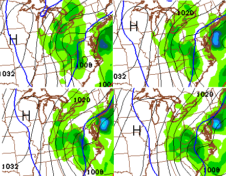 Wherever that band sets up could pick up on some quick accumulating snows. The snowfall map from the NAM looks like this…
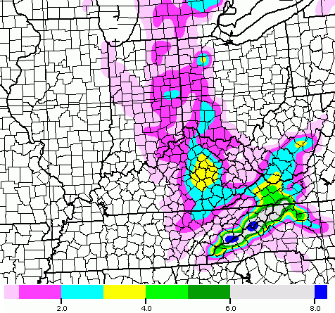 That is likely overdone in central Kentucky because of the mild ground and melting. I also think it’s a little undercooked across southeastern parts of the state.
I’m probably closer to the GFS snowfall forecast…

A few thoughts:
– Temps still look to surge toward 50 before crashing down from west to east Friday afternoon. Gusty showers will be around and a rumble of thunder is even possible.
– Trick or treat hours will find temps dropping through the 30s with gusty winds and some rain and snow filling the air.
– Wraparound band of snow moves in Friday night into Saturday morning across central and eastern Kentucky. That’s the one that could drop some light accumulations on grassy areas and elevated surfaces. I will have a First Call For Snowfall coming up on WKYT-TV starting at 4. I’ll put that on the blog and adjust as needed later this evening.
Enjoy the day and take care.

Definitely, a once in a half/century set-up building for Halloween time.
An arctic storm diving down through the Ohio Valley into the Carolina’s is just a very odd sight on the map.
Accidently put this in the last post:
If this was the heart of winter, we would be talking about several inches. The atmosphere is amped.
I expect Louisville and points east to all set records for Halloween.
Of course, that only takes a tenth of an inch or more 🙂
Thanks Chris for all you do weather. Got a new meaning for the acronym WWW: Winter Weather Weenies! 🙂
Warm air is hard enough to move out of east ky in the middle of winter so I ain’t holding my breath. We will see I guess. Interesting to follow
Wow. Waaaayyy too early for this kind of set up! Interesting for sure. Thanks Chris.
Wonder if its a sign of things to come..?
Team NAM!
“decent blast”, doesn’t seem to match up with all the prior descriptions this week. Let’s hope this doesn’t mark the beginning of change in direction.
This weather is going to be a great opportunity for parents to take their snowflakes out into the snowflakes.
I have no idea what you mean.
Blow some of the snow to Virginia. It would be nice to see some flurries. Although our local Met is calling for the southwestern counties to see such; it would be great for Richmond also!
Model runs sure looked interesting today…If the trend continue’s look for more counties in the east to be included in the watch area..Just my humble opinion..