Happy Halloween! The forecast continues to remain on target with a blast of winter weather blowing into the bluegrass state. The action begins this evening and continues into Saturday across central and eastern Kentucky. I have the blog set up for all your tracking needs.
Some quick thoughts:
– The big drop in temps will take place behind the front that passes through here late afternoon and early evening.
– Winds will really crank behind the front with 35mph gusts possible this evening. That’s when temps drop into the 30s and snow mixes in with the rain.
– The models are still VERY enthusiastic in developing a band of moderate to heavy snow across central and eastern Ky overnight into early Saturday.
– Lingering snow showers and flurries will last through Saturday in the east and southeast.
– Some slushy accumulations are likely across much of the area into Saturday morning. Yes, we will have a lot of melting snow, but it should fall hard enough to overcome some of that. Throw in temps going below freezing overnight and light accumulations look good, especially on the grass and elevated surfaces. Here’s the latest call…
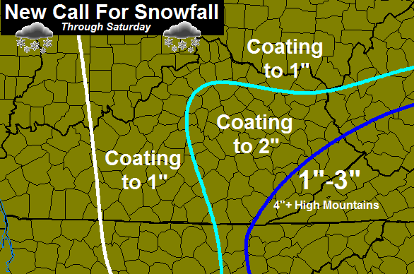 I will have the Final Call For Snowfall on WKYT-TV starting at 4. I leave you with the tracking tools…

Current Temperatures

Sustained Winds

I-75 @ Winchester Road Lexington
I-75 @ Iron Works Pike Lexington

I-75 @ Clays Ferry Bridge South Between Lexington and Richmond

US 60 @ US 127 Frankfort

US 127 @ Frankfort Frankfort

I-75 at MP 36 London

I-71/I-75 at Buttermilk Pike Near Covington

I-64 @ 3rd St. Exit Louisville

Downtown Louisville @ 2nd & Broadway Louisville

I-65 @ 234 Near Bowling Green

Happy Halloween and Happy snow tracking. Take care.

There goes the all the bread & milk
LoL Probably true even though it will be back in the 60s Monday.There is just something about that word that triggers the urgent need to get to the store and buy milk,bread,and eggs.
I am looking forward to this short round of winter.But it is going to be awfully cold on the kiddies out for Halloween.
Nice to see the NWS completely onboard with CB’s thoughts. Winds and heavier rain showers in Louisville leaves are falling about as fast as the rain is coming down. Im going to go ahead and hoist a Excessive Wet Leaf Warning. Caution wet leaves covering street’s this afternoon and evening will provide slick conditions for motorists. lol
A light shower accompanied by a blast of north/northwest winds drops temperature nearly 5 degrees in a short time…now at 43 in Valley Station near Louisville.
Yeah I’m sitting at 44 degrees
41 at Westport rd/Gene Snyder
can anyone possibly forecast the winds/gust for tomorrow?
State Marching Band Semi Finals are taking place in Berea ( Madison Southern) tomorrow and I’m just trying to devise a plan.
I appreciate any thoughts.
My thermometers on the front and back are both showing 41 now.Still light rain.Hasn’t really stopped all day.Only a slight breeze.I think most the leaves will be gone once all this wind starts blowing harder and hangs around for the weekend.Dreary looking time.Very fitting for Halloween.
Use your smartphone to tell NWS what precipitation you are seeing while you are on the go or at home. It’s the mPING app…
Here’s a current display of reports for our area…
http://www.nssl.noaa.gov/projects/ping/display/
Notice that ice pellets or sleet is mixing in with the rain around the Louisville Metro.
Love to be in Gatlinburg this weekend 2-4 inches expected in Gatlinburg but go a few miles away from Gatlinburg into the mountains around 2500 feet 6-12 inches above 5000 ft amounts as high as 18 inches expected.
44.1 in Pike
Temps are dropping.Down to 30 here but the breeze is making it feel colder.No strong winds yet.Still getting light rain.
37 and snowing on Dorton Hill in Pike County.