Good Thursday, everyone. Arctic cold continues to take hold of the bluegrass state and much of the country. Believe it or not, things are going to get MUCH colder around here over the next week or so. Throw in the increasing potential for snow and you have a super duper wintry pattern.
Some areas may see a few flakes today as a push of colder air sinks in from the northwest. Flurries will be possible across much of the region, with a band of light snow possible in the far east and southeast. Highs will generally run in the middle 30s, but gusty winds will make it feel in the 20s.
Current temperatures


Temps on Friday will be even colder with lows around 20 and highs in the low and middle 30s. Wind chill numbers may dip deep into the teens at times.
Saturday starts very cold with readings in the low 20s under clear skies. Clouds will increase during the day with highs back into the mid and upper 30s. Those clouds are ahead of a weak system scooting in from the west. This will bring a band of light snow our way, but a lot of the action will dry up as it reaches the area. Still, this could be a sneaky light snow maker for some.
The main system continues to come together from late Sunday into Monday. Low pressure will develop across the deep south and track through the Carolinas and up the east coast. The track and intensity of that low will determine how much of a winter weather impact we see around here. The dueling versions of the GFS continue to advertise the potential for accumulating snows.
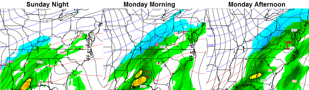


Right or wrong, you have to tip your hat to the GFS runs for being pretty consistent with the overall scenario.
The European Model continues to have a few issues in resolving what to do with all the energy coming in from the southwest. It’s starting to figure things out, though. It also shows accumulating snows…

I think it’s later today or tonight when we see more of a model consensus on how much, if any, snow falls where you live. Odds certainly favor some snow, but it’s too early to get more specific than that.
Arctic air pours in behind that system and the models show some absurd cold for this time of year…

IF temps can get that low, records would be in jeopardy. That’s some wicked stuff showing up!
I will have updates later today. Take care.

Could this winter be another ’76 winter? I dunno, but that’s mid-jan temps in mid November!
The temps are definitely starting out that way. It’s cold! However, I’m seeing some reports of mid 60’s again by Thanksgiving which would be very nice. The winters of 76-77, 77-78 were cold from beginning to end.
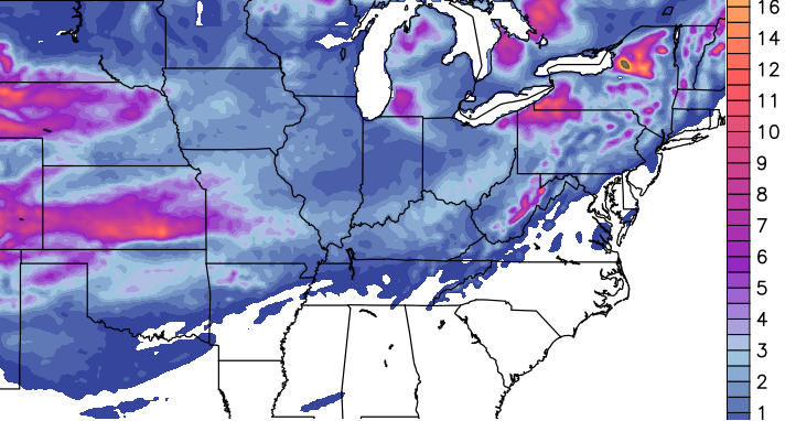
Models not as bullish on the snow this time around.
…looking forward to see how this early season possibility plays out. Even for a snow and cold lover, I am not sure I want it this early.
this is going to be a roller coaster winter with temps; forecasts for thanksgiving and black Friday has highs around 65 — don’t close your eyes because the freakin weather will change around here in a blink !!!
What source has already released a Thanksgiving/Black Friday forecast? I can’t find anything past 10 day forecasts online. Where are you obtaining this information?
I really don’t want a warm Thanksgiving or Black Friday. 🙁
Excited about the cold and snow!
🙂
CB,
Thank you for all your hard work and dedication!
Don’t like the northern shift of snow/rain…
Hey blizzardtim, long time no hear. Even though I’m more of a warm wx person, still don’t mind some winter. Snow now falling in Memphis and earlier reports of some flakes in D-i-c-k-s-o-n County TN west of Nashville, but no snow here in Nashville for the moment.
getting concern bout the WAA that showing up
WAA?
Warm air aloft. That is warm air changes the stuff falling to rain and then is freezes IF the surface area is frozen.
This seems to be a small event as far as snow accumulation. Still too early to say, but the combined “solution” of the models do not appear to be suggesting much snow.
I would also suggest the lack of posts is through the years the folks here have become more savvy and appreciate CB is just posting his thoughts and NOT a forecast. The only wintry event that is fairly model accurate beyond a day or two out has been ice.
Snow in this region is nearly always a crapshoot 😉
Thanks for the clarification. I actually deciphered it as “Warm Air Aloft” just a couple of minutes after making the post!
What this blog needs is a good old 12-20 inch thumping at least once this winter, so we can all get the “old school” out of our system. I still remember 76-77 and 77-78. If we had a winter like those, even the die-hards would get tired of it.
LOL! Rolo starts his usual flip-flopping already.
I caught that too! 🙂 Patting on the back and suggesting even bigger and now backing off with WAA concerns. I personally would not have it any other way though, since the Rolocoaster is part of the fun of this blog.
Gives the blog more character 🙂
Getting a light dusting of snow in London on cars and rooftops. Nice to have a little taste of winter for the kiddos, and adult kiddos.
I thought some people around here might find this interesting so I figured I’d share. John Belski with WLKY in Louisville posted Louisville’s heaviest snowfalls:
22.4″ February 4 – 6, 1998
15.9″ January 16 – 17 1994
15.7″ January 16 – 17 1978
15.0″ December 7 – 8 1917
1917 was obviously before my time and so was 1978. However, I remember the storms of 1994 and 1998 quite well. That ’98 monster gave us over a week of snow days from school! As a kid with nothing better to do than go sledding and build snowmen, you couldn’t ask for much better than that. Every Winter I hope for a repeat of that event… maybe this year is the year? Heck, it doesn’t even need to be that much. I’d be stoked with anything over a few inches. Seems like that’s the best we get here in Louisville for any one snowfall anymore. Keep hope alive!
Not understanding your statement Louisville gets the fair share of snow just last year Louisville doubled there average snowfall.
Me think’s he yearn’s for an “old School” like in day’s past…Nice to see some mood flakes flying around today around to get one excited about winter…
Minus one “around”..lol
A flake or two a fallin’ here in Carter Co. Hope we get some more.
Snow coming down pretty good in Floyd co. Melting as soon as it hits the ground though. That’s why i doubt any measurable snow in this next system. Ground is just too warm. I’m hoping I’m wrong though. Lol. Thanks for all the updates Chris. Keep them coming please!