Good Tuesday, everyone. The weather we have out there today is just about as cold as it can possible get this time of year. Record lows and record cold high temps may fall in many areas today as the November version of the North Pole settles in.
Morning thermometers will likely start in the upper single digits to low teens for many. Wind chill readings of below zero will be a strong possibility at times. Throw in roads that are icy and, in some cases, snow covered, and it’s a brutal start to the day.
Highs today have a shot at staying in the upper teens across the northern parts of the state. Most areas will see readings in the 20-25 degree range. Gusty winds will make it feel much colder than those numbers indicate. Overall, this is likely the coldest November day in our region since the 29th and 30th of November 1976. Think about that one for a moment!

Current temperatures

Wednesday will start in the teens with highs reaching the 30s with winds and clouds increasing Those clouds are ahead of another arctic front that swings through here Wednesday night. That should touch off a band of light snow and flurries…

The air behind that isn’t as cold as what we have, but would hold up on its own in any other November…

Keep an eye on late Friday into Saturday morning as milder air fights in. I’ve seen situations like this in the past produce a little frozen precip. The high resolution GFS is close to showing that…

That leads us into a brief mild up for late Saturday into Sunday. It comes at a price with rain, thunder and gusty winds increasing ahead of a strong storm system. That system lifts to our north and pulls colder air back in for Monday with some rain and snow possible…
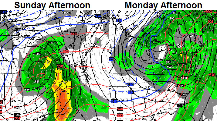
That’s a pretty cold pattern moving back in for Thanksgiving week and it’s one that may crank out another big storm. The High Resolution GFS is picking up on that potential…
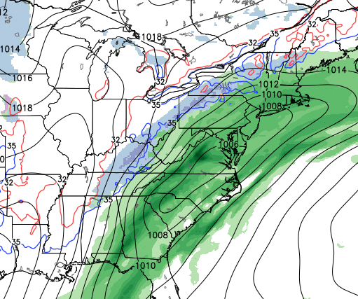
The Canadian Model has something similar for the busiest travel day of the year. The European has also been picking up on this signal at times.
And you thought we wouldn’t have any fun this November! 😉
I will have updates later. Enjoy the bitter cold and take care.

I’m waiting to hear your prediction for Thanksgiving day before I make plans as to where to go this year. If it’s going to be snowy I don’t want to travel as far. Looking forward to hearing your thought on turkey day Chris.
14 degrees. New record low for this date in Fayette unlocked! Hopefully, the official version agrees with the Mesonet station up there.
Madison Mesonet low of 17, with 18 to 19 here in Berea. Silver lining from yesterday, my pipes are happy with the warmer ground temps and higher air temps down here.
Hmmm Thanksgiving looks to get very interesting with the placement of the rain snow line and the NW shift. Ha Ha!! I still have leaves to get up at multiple properties. Hard to do with snow on the ground. Oh well love the snow and cold just not this early. Thanks Chris for your hard work at keeping everyone informed.
Just carbon copy this event 😉
Will be interesting how many people bite the model bait only to get reeled in about a day or two out. CB though has to roll with the models, since the one time he takes “the shift” into account, it will hold fast and not shift.
Thanks Bjenks! I don’t have a clue about how to read the longer range stuff. Snow for Thanksgiving would be great.
I’m in the same boat with the leaves. It’s never ending for us…
20 here in carrie of knott co this morning
No school here today. Snow on the roads and 20 degrees with strong winds.
Snow is really coming down in huntington…ground is getting covered
The 20 degrees earlier was from a thermometer on the porch. At 8 am the temperature at an official weather station is 16 degrees and we still have flurries. Too cold to get out…I’m stayin in.
Nice to have an unexpected inch of snow overnight to cover the roads and get us out of school in Laurel County. Enjoy your day.
almost time PLANES,TRAINS and AUTOMOBILES!!!!!!!!!!!!!!!!
I’ve been thinking the exact same thing! ^^^^