Good Sunday evening, everyone. Heavy rain and high winds are arriving right on cue. Gusts to 50mph will be possible overnight into Monday as a powerful storm works into the Great Lakes.
I continue to be focused on the Wednesday through Thanksgiving period for the potential for winter weather. We continue to see the models cranking up a big east coast winter storm. Each run edges this bad boy a little farther west and that’s a trend we may see some more of over the next few days.
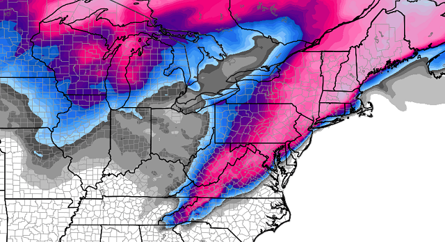
The European Model shows the snow shield with this storm crossing eastern Kentucky…

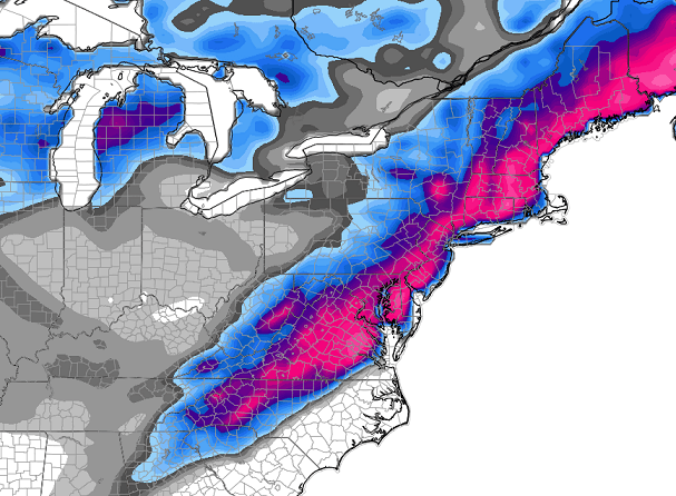
That’s a monster storm rolling up the east coast and will cause travel nightmares on the busiest travel day of the year. You can also see the second system diving at us from the northwest with some light snow. Here’s the European Model snow forecast…
The late day GFS is continues to run straight toward the European Model…

It is also bringing the accumulating snows from that storm across southeastern Kentucky…
As I said a few days ago, the setup was there for a much bigger storm system and it wouldn’t take much to get it to impact Kentucky.
Now… does the infamous northwest trend on storms kick in at this point? If so, it’s a much bigger impact on our weather. That is a big IF at this point, but it is certainly something to watch.
I will have another update later tonight. Take care.

Ah, New England, you always have all the fun. I miss it.
Come on northwest trend!!!! Let’s do this! Laurel County is rooting for you!
So close, and yet so far!
Hey this is something to actually watch for. Models always do the north and west trend. Since it starts off this far south, I almost know for certain that the main band will end up somewhere in Kentucky, and whoever does get this snow, will get pounded! Northwest trend = stronger system also, the weaker, the more south. This will be fun to track…
Perhaps the MSM (Mike’s Snow Model – take the axis three days out and shift it 75 miles northwest…no science involved, just lot’s of experience…) will win out!
Hoping to see a little white stuff to start the holiday season! Everyone be careful. It’s too soon for me to get my hopes up. I live in Richmond, VA; we have a dome over us that prevents us from having any snow:(. Everyone be careful just in case.