Good Monday afternoon, gang. The winds out there today have been everything I expected and then some. Gusts have topped out at 60mph+ in a few spots. Trees are down and thousands are without power. Those winds are ushering in much colder air that will set the stage for possible travel troubles on Wednesday.
The day before Thanksgiving is the busiest travel day of the year across the country and Old Man Winter is going to cause some big issues.
A massive winter storm will slam the eastern part of the country as a light snow maker zips across the Ohio Valley from the northwest. Each of these should impact the weather across Kentucky. The question is… now much of an impact will each have?
The east coast storm is likely to throw some snow across southeastern parts of the state. The European Model has been the farthest west with the snow shield. The latest SREF also shows a farther west extension of the system…

The new European Model comes out in a bit and I will tweet about what it’s showing.
The GFS shows snow across southeastern Kentucky with the east coast storm and has the separate swath of snow from northwest to southeast…
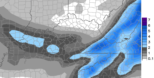
That second system mainly comes late Wednesday into Wednesday night. One way or another, travel across Kentucky looks to have a wintry impact on Wednesday.
I will have another update later. Take care.

I get so excited about all the extra post. I find myself checking very often to see all the comments. I like it read everyone’s input.
Thank you Chris for thinking enough of us to want to keep us updated on the weather.
And thank you to every one else for your thoughts !
Wow, it’s good to see almost the entire state of Virginia covered in blue. Thank you Chris for making this easy and keeping us informed. Even though I’m in VA; it seems that we get whatever you all are getting the next day.
I’m happy for Virginia and the entire east coast that are snow lovers! Especially my N.C. friends in the sandhills where I lived for a time. Snow is sparse there.Yay!
I see NE KY is getting its normal allotment…
And very far eastern ky. Maybe top bkack miuntain
Still very early in game. Lot if snow potential yet. Chris made nols prediction of widespread double digit snowfall this winter gor first time since 1998. Was 1996 for southern ky but 98 dusting did give 7 or 8 inches of heavy snow that broke trees down. Chris’ bold prediction of very cold weather came true last year. We will see how this one goes.
I gotta feeling that warmer air wins out again for the most part. NWS in Jackson not really biting on a colder scenario either.
Frankfort has had 3.5 inches of snow in November so far, I’m not ready to complain if we miss this next snow chance.
Very early in the game!
70s in southeast Ky. today, 40s north and west. Impressive temp spread..
Traveling to Winchester VA on Wed. I hope it doesn’t get to bad.
Great updates, Chris! Thanks so much.
Looks like Lexington is out of the snow chance this time. Here’s hoping the SE part of the state rings up something from this.
I gotta believe we’ll get our biggun’ this winter!
Looks like the Huntington WV area is a miss again. Very typical, everything misses to the East or Northwest. I guess all we can hope for is the dreaded wrap around flurries.
Traveling to DC/Chevy Chase, MD for the holidays… here’s hoping I’ll be able to make it back for work on Monday!