Good evening, gang. The late day model runs of the GFS and NAM show a more westward expansion of the rain and snow shield from the east coast winter storm. The GFS is really amped up pretty far to the west and shows snow possible as far west as Interstate 75 late tonight and Wednesday morning…
 That would certainly impact many more folks if it’s correct.
The same model run then brings the next system in from the northwest and adds to the snowfall potential through Thursday morning…
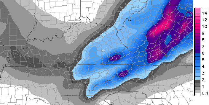 The NAM shows much higher totals across far southeastern Kentucky, but isn’t as widespread with the totals from either system…
 A Winter Weather Advisory is already out for far southeastern Kentucky through Wednesday…
 I have to admit that I’m more impressed with the potential now than I was even earlier today.
I will have updates as needed and could even upgrade for southeastern Kentucky if the trend continues.
Take care.

tx CB!!
I really wasn’t expecting it to actually snow enough to matter so I hadn’t put much thought into it.Flurries was the most I had hoped for.
Wouldn’t it be something if we really did end up getting a nice little snow from this for Thanksgiving.Thanks Chris.
Thanx CB. Crossing fingers for a couple of inches of holiday cheer.
I am still a bit skeptical, especially since temps are still in the mid to upper 40’s in Huntington WV. I hope Chris is right with his westward trend. But it would not surprise me a bit if it didn’t end up all rain in my part of the world. Happy Thanksgiving to all.
Bring it on.
May the westward trend continue! A nice skiff of snow or even a few inches sounds good to me. Yes, it might not stick, but then again it just might. At least we have some probabilities, possibilities and with a little luck, maybe a little snow. Yes!
I wouldn’t hold my breath over expecting any accumulations
Seems based on a new tweet, CB is backing off from any significant event chance for EKY for Wednesday and noting a chance for Thursday.
Makes sense since if 40s during the day, not much chance for snow to hang around.
Probably same for Thursday due to temps.
Even before the tweet you mentioned, No Threat Mode for the blog is a consistent vote of low confidence in anything happening this close to the event. We both know that, despite what else may be discussed.
Btw, did you catch the mentioning of “signals” the other day? If MJ and some of the other mets were still around here, they’d be tickled.
CB, you backing off due to rain mixing in, or because the precip shield will be too far east..?