Good afternoon and Happy Thanksgiving. Here’s hoping you are having a wonderful holiday! Snow blanketed many areas of the bluegrass state this morning, giving us a rare snowfall on turkey day. A few more snow showers and flurries will fly through the rest of the day, but I wanted to talk about where we go from here.
Black Friday is still a cold one with moderating temps this weekend. A few showers will be noted late Saturday into Sunday. Colder changes continue to show up on Monday as a strong cold front settles in from the north and northwest. This means a HUGE temp crash is coming to start December. We may be near 60 as the strikes midnight with a 25-30 degree temp drop coming by the afternoon.
Can you find the front on the European Model for Monday afternoon?
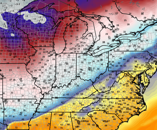
Now THAT is a cold front! The cold air will continue to press to the east as the front slows down. A couple of waves of low pressure will develop along this front and roll toward the northeast. That can bring wintry weather back into the region. The European shows where it thinks wintry precipitation will fall Monday and Tuesday…

That will be something for us to watch closely because the temps tend to show up colder and colder the closer we get. All of this is part of a back and forth pattern I expect for the first half of December, however things are certainly looking colder than even I was thinking. The Canadian Ensembles show the return of a familiar pattern around December 10th…
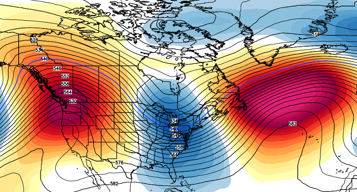
A big ridge up the west coast into Alaska with a deepening trough across the east. If we can get that ridge in the Atlantic to pop a little farther north into Greenland… look out.
Happy Thanksgiving and take care.

Happy Thanksgiving Chris.Today has been cool but overall nothing to complain about here.There has been a mist that leaves what looks looks like a thin layer of ice crystals on the porches and the steps most of the day.
We had light snow on the rooftops and on the leaves but no accumulation this morning.Made it pretty to wake up and see that on Thanksgiving morning.Don’t think our temps got above 30 all day.
Most the sites are still showing us in the 50s and 60s for the next week but looks as if its going to be quiet a bit cooler.
Hope everyone is having a wonderful Thanksgiving.We all have much to be thankful for.
Happy Thanksgiving Chris!
Happy Thanksgiving from London, Chris! Thanks for all of your hard to keep us all informed and enlightened about all things weather. I hope you had a great day. Today’s light snow was a nice touch to the “official” start to the Christmas season. Looking forward to more weather talks, lessons, and the like.