Good afternoon, everyone. Getting ready to head out to Fayette Mall to ring the bell for the Salvation Army and wanted to throw you a quick update.
The European Model continues to be a friend to snow lovers across our region. Take a look…
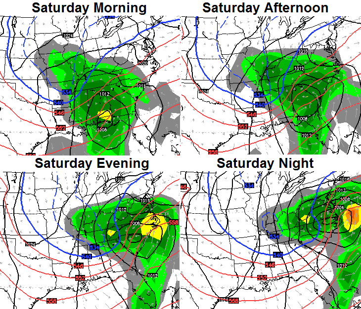
 Other models aren’t as bullish on this scenario, but if there’s one model you want on your side, it’s the European Model.
Check yourself, though… that’s still a week away. I’m just sharing a model with you guys. 🙂
I will try to update this evening. Take care.

The track of the low on the EURO through southern Alabama, Georgia, and up the coast is absolutely beautiful and ideal. My worry is, will it trend north and become a lakes cutter? The NW model trend comes to bite us sometimes. Hopefully, things remain on our side for this one, but one things is for sure, the upcoming pattern is loaded with opportunity.
Track to the South really needs to be on the Southern Tenn. border and then up this side of the Apps. for Louisville to get there best snows. With saying that the current track is perfect for the NW shift. Liking the looks of this even know it is a week out. Thanks CB for the update…Nice win by UK today…
I’m not a snow lover chris.
Thanks for the update!
Thanks to Chris Reece for the expertise. I guess I was hoping it would come a little north to hit CKY smack dab. Just not too much NW?
And I understand, it’s a week away. Fun stuff!
You can have all the snow ya want retro fetch.I’m not a fan of it myself.
I understand, Danny. Hope it misses you if we get any.
I wonder what the MSM from 3 days out will be?
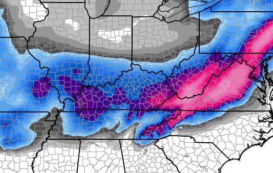
Please give me numbers with those pretty colors. How much snow is blue and purple? It is nice to dream. I love the snow!!!