Good Monday, folks. We’ve made it into the midway point of December and it’s time to shake things up in a big way. The first part of the month was talked about as a reloading period coming off a record cold November. The past few weeks missed a chance to give us some mild weather and now winter is planning a big return for the second half of the month… just in time for Christmas.
Today looks to be another dreary day in the bluegrass state with temps ranging from the mid 40s to around 50. Rain will increase quickly from west to east late today as a cold front sweeps in. We may even hear some thunder out of this.

Current temperatures

The showers will continue into Tuesday with very gusty winds and falling temperatures. This action may end as some snowflakes Tuesday night and Wednesday with highs in the 30s.
I’ve been talking about the possibility of a sneaky snow system showing up Wednesday night and Thursday and the models are trying to hone in on this. I think the best chance for some light snow will be across western and southern parts of the state. Whatever is out there may dry up the farther north and east it tries to get.
That brings us to the end of the week and weekend potential winter storm. A check of the models will find the Canadian with a low pressure along the Gulf coast and moving eastward with no impact on our weather. The GFS has some wacked out solution of a weak low pressure working all the way into Ohio. The poor model doesn’t even come close to matching what it’s very own Ensembles show…
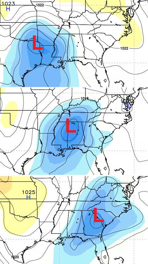
That’s Friday night through Saturday and is a good winter storm track for much of the bluegrass state. That’s very similar to what the European Model has been suggesting for the past several days. That model continues to show this storm having a significant impact on the weather around here. Here’s where the latest European Model shows the best chance for snow and frozen stuff…
That zone bounces around from run to run based on whatever track of the low it shows at any given time.
I have to put out the standard disclaimer with this: I am not telling you we are getting a winter storm this weekend… but I’m not telling you we aren’t, either. What I am saying is there is the POTENTIAL for a decent sized impact across parts of our region during this time frame.
The models will continue to spit out varying solutions for a couple more days before settling on some kind of solution. It’s always important to never get caught up in one model run. Look for trends, instead.
There continues to be a strong signal showing up for another potential winter storm around Christmas. The various Ensembles have been all over this for the past week and now the medium range models are sniffing something out. Even the GFS (which actually can be of some use at this range) is showing my concern. Check this big dip in the jet stream…
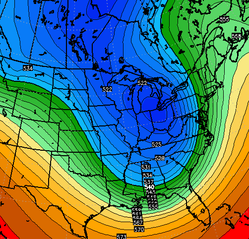
That could produce a major storm for the Ohio Valley and Great Lakes…
To see that kind of signal on the GFS from this range should be enough to get some folks attention. Why do I say that when I can’t stand the model? Because it matches the pattern with that storm and matches up with the Ensembles.
Another system would try to follow that up a few days later as arctic air starts to take hold.
I will have updates later today. Have a good one and take care.

CB the westward trend showing up on EURO.
Actually rolo looked to me like it shifted SE ever so slightly..
Appears the average is a NW trend, but I could EASILY be reading it wrong, based on factors CB mentioned.
South of I64’s 33/32 “law” seems to be in play again though based on the temperatures. Just watch out for a girl wanting someone to kick a football 😉 🙂
No actually rolo is right. On the evening runs almost the entire state was covered in pink. Now se ky is barely even in any blue
Wow…..the looks of the Xmas storm is larger than this weekends…hope they both come across all of KY with old school thumpings….not trying to jinx us, but the trend has to be broken one of these years. Thanks for the update Chris.
When you have good agreement between the operational and ensemble mean of the European model it’s a hard combo to beat..Today’s run sure will be interesting..
Catch is the models seem to not reflect reality until less than 48 out. CB is spot on though at least mentioning the potential, none the less.
Euro caught the early Dec storm really well a week out. That is why I like our potential for this one.
Sorry early November not Dec…
What I don’t like about the weekend storm is there just not alot of cold air to work with. Of course the path concerns me with the low that northerly jog seems to get us more times than not. To early in the game to really know what might happen. Key word is potential.
True. Depends on the system, since some models appear to favor specific types as far as getting them in the realm of right.
One thing seems a given and that is the ingredients at least are in going in place for the possibility.
Great info for us, Chris! This will be fun to watch.
Great to hear the armchair forecasters getting in the mix too!
Well I’ll take that southern shift..so me and tennmark can get some snow here in east tn!!
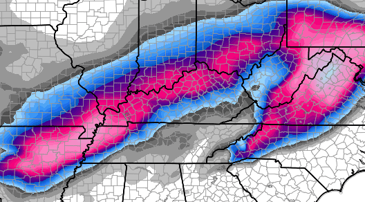
Mr Bailey, could you please include a snow amount key to coincide with the colors on the potential forecast map? I realize as you have said that it doesn’t mean you are calling for these amounts,but it would be fun to see at least. I have no clue what the colors mean. Thank you for all you do for us CB.
Ben, this is an approx. accum. amounts. Gray= trace-2, blue= 2-6, purple= 6-9, hot pink= 9-14, light pink= 14-20. Hope that helps. Somebody correct me if I’m wrong 🙂
and the hype train is starting, ALL ABOARD
woooo wooooooo
It’s a shame that the American model (GFS) is almost useless in the winter in the long range. You would think if Europe can come up with a decent computer forecast model, that we could.
Bah Humbug.
Is it looking like the rain/snow will move in early or late Friday night?
Rooting for the Euro to stay the course (if possible…shift a little SE). As often the case…cold air will be the big question, but I don’t think Gulf moisture will be lacking with this system. That alone is a promising start…
GFS its initial’s stand for Going For Stupid
Don’t worry the 18z run of the GFS will have the low in New Orleans then from there head to the Gulf gather strength turn into a hurricane before making landfall in Tampa Florida.
I’m always glad I live in extreme Northern KY! We get the shaft sometimes too but the odds are always a bit better up here for us. I hope we can get another 50″ plus snowfall year this season like last year. Lol! 😉
For what it’s worth, and it’s probably not worth much lol, even Henry margisuty (sp?) is liking the European track of the storm
I am betting the storm takes the usual NW track, thus shafting SE Ky and Western WV with another 34 degree rain then backside flurries. This trend is like clock work. Overall a pathetic start to Winter, November was cold but it was wasted cold unless you lived in Buffalo.
So I’m guessing eastern ky don’t have a chance just please no rain don’t want rain for christmas just soon it be dry and cold
The latest weather blog update from WAVE 3 here in Louisville outright says the odds of a white Christmas in Louisville this year are “slim”.
That poses an interesting question: What do you consider to be a “white Christmas”? Does is actually have to snow on Christmas? Or does it count as long as there is snow on the ground?
That blog update on Wave3 was written by Christie Dutton Im not real sure what she was thinking by saying (slim). In my opinion she inserted her foot in mouth by saying that. Next week there should be better supply of cold air to work with and there is a storm looming around the Christmas time frame. In order to have a white christmas officially there suppose to be a inch of snow on the ground.
nothing to see here fot r weekend, maybe ohio river counties get it, but they too may be just rain. the track of today low great lakes cutter, next low will pull futher NWas well
Rolo!?! What’s wrong with you were still 4 to 5 days out and already given up? Even if this weekend storm is a lake cutter and if might be the next storm that follows will be more supressed to the south. The cold air from the north along with the snowpack should push the storm track futher south.
Prelude is correct…
Typical Rolo tomfoolery.
THIS IS FAKE!! Some people are gullable
IM WISHING FOR A WHITE CHRISTMAS HOPE THIS IS THE BEGINNING……..”)