Good Monday evening, gang. Old Man Winter looks ready to return in a big way over the next couple of weeks. I’ve been trying to drive this point home since back in November and I see ZERO reason to change my thoughts.
The action gets started with the potential for a streak of light snow and flurries for parts of the region Wednesday night and Thursday. The European Model shows the areas having the best chance to see some flakes…
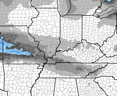
The best chance will be in the west and south, but some flakes could fly anywhere at some point.
The same run of the European Model is a little farther south than earlier runs with the weekend winter storm potential…
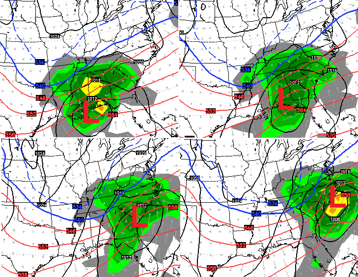
Again, the models will show deviations from run to run and that always happens. As I mentioned a few days ago, there’s a better chance this storm goes too far south than too far north and produces just rain.
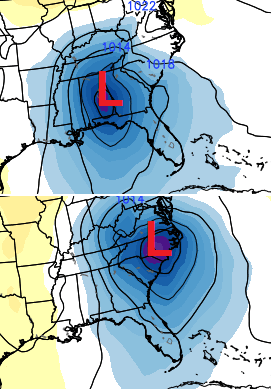
The control run of the European Ensembles basically didn’t budge with what they have been showing in recent days…
The GFS continues to be lost in the woods, but the “new” GFS continues to strongly trend toward what the European Model has been showing in recent days.
It’s still pretty early in the game, but the potential for a decent winter weather hit for our region is increasing. It’s far from a sure thing, but you have to like how things are looking from 4 days out.
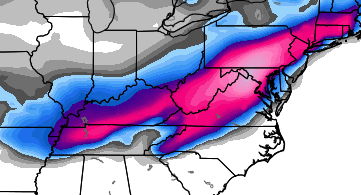
Speaking of looking good, the signal for some Christmas Eve and Day fun continues to show up very well…
 Buckle up… we have a lot of winter on the way.
Take care.

I’m seeing this right when I’m not in a good mood at all chris.
Well that’s just a crying shame
I would really like to see the Canadian model data. It has been pretty accurate here of late.
Your the #1 guy to go to for weather, although I have been following joe bastardi and Brian Goode a little. But your still #1.
Keep up the good work Chris.
Can someone breakdown the snow map?
Brian says the track should be south of here, but strength of storm is what he is watching. A weak system and not enough cold air, a stronger system and a full blown winter storm. So, well see.
Southern shift is encouraging for sure. It’s the only way we in the southern counties have a chance of a decent snowfall. Crossing fingers without actually getting my hopes up.
I live in Shepherdsville, so I`d like to see the ensembles move a little further north.
I would take the south right now Tim. The models always seem to come back north, unless it is a deep south freezer.
Hopefully this low strenghens and pulls just a tad NW…Although Chris says it has a better chance of going South than North. If it strengthens it will pull North. Like the chances for all of KY. Thanks for the update Chris.
I think it was about the year of 2010 on the 18 th of December it came a snow here in Jenkins Ky. The power outage was wide spread. My oldest daughter and her family ended up having to come stay with us for two weeks before her power was restored. Christmas for her little family was spent at our house… The only not so bad part of that was the temps stayed above freezing.
does anyone know the snow total’s yet
No offense, but can you louisville folks chill? You guys act as if you never get a flake of snow.
Personally I want the further south and less wound up storm. Would rather have widespread 2-4 amounts in downstate Ky then watch Louisville and southern Indiana get hammered yet again
lol
Thank you, Chris. Maybe this one can hit the right track and give a decent snow to a large part of the state.
It’s still early in our season for snow.
I wish I knew which part of Louisville it is that always “gets hammered”. It’s certainly not the part I live in.
^^^agreed!
things looking better for area coverage of snow. tommmorn runs will get the answer.
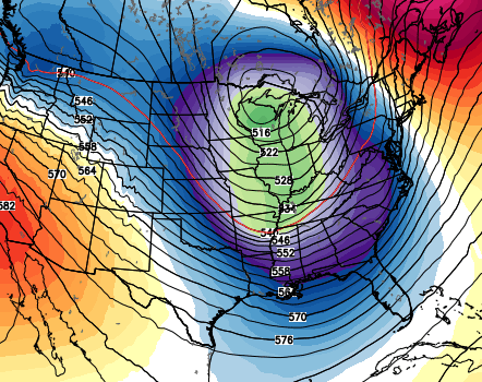
One Louisville Met (Not Brian) says not to get too excited about this. He says its still out to sea, so there`s no way a model can hone in on it. According to him, the Euro is only showing 1 to 3 inches state wide. The picture, above, shows more than that. Or at least I thought it did. Plus I think he said the GFS is showing mostly all rain.
Louisville doesn`t get “Hammered”, about 25 miles north of here has been though.
I hope Chris is correct. I watch his and Brians blogs, both are great.
right now see 1-3 central/se ky as storm gets to east the back side, OHIO RIver counties maybe more up that way. storm gets crank up colder air, if its weaker temps will be questionable as far as anything much.
Seems the key word will be Mix for most of us. 33/32 could win once again, but looking forward to CB’s forecast.
33/32 wins again im afraid.
the gal with the football wins again. the the guy trying to kick the ball ever kick it?
I couldn’t imagine a better present from Ol’ Man Winter than to be able to make a snowman on Christmas!
Well we ve got a shot but as usual the odds here in Ky. favor wraparound nothing or 35 degrees and rain lol. I d say 15 % chance of weekend snow, 50% chance of nothing….35% cold rain…:)
Whoa, whoa, we already had 1/8″ back in October. I don’t know if we can handle another 1/8″ so soon.
Still looking for an accessible snow for kids sledding in christian county, just two kids and an old gram trying to play a little. Any suggestions please post here!
i think a widespread dusting to 12″ is a safe bet at this point
I’m pretty sure that if I rely solely on nowcasting, I’ll save myself a lot of heartache .