Good afternoon, gang. Here’s hoping the day is treating you well. Colder air continues to push into the region and will knock our temps way down from where we’ve been in recent days. This leads us into a pattern loaded with winter over the next few weeks and that action starts later this week.
We could actually see a few snow flurries flying around tonight into Wednesday with highs in the 30s.
The Thursday system keeps upping the chances for a period of light snow and flurries for much of the state. The NAM is jumping on board with this potential…
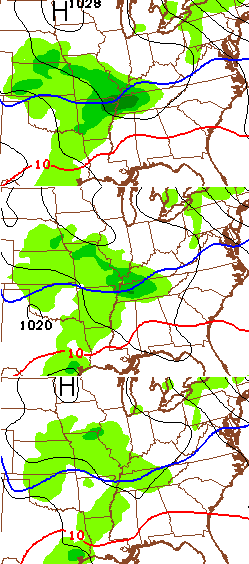
The best chance continues to show up across the western and southern parts of the state. The Short Range Ensembles Forecast (SREF), however, does show more moisture farther north and east…
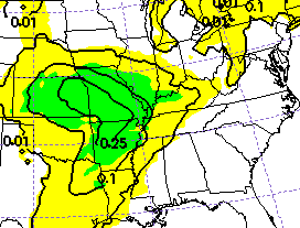 If the ensembles are correct, the threat for some light snow would come farther north and east. That’s a trend we will keep watching.
I’m also watching the potential weekend system that the models continue to be all over the place with. The regular GFS still can’t get anything right in the lower levels or upper levels of the atmosphere. Throw in the fact it is also having convective feedback issues, and you have a model that is still useless.
The new version of the GFS appears to be getting better organized with this system, but offers up a choppy winter precipitation shield…
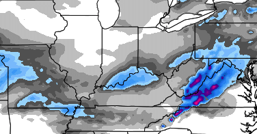
The SREF is offering up a very expansive precipitation shield at the very end of it’s range (Friday Evening)…
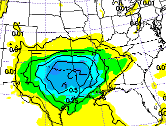
The models are a long way from figuring out the Thursday system, let alone what will happen this upcoming weekend.
Speaking of the weekend, I have to admit, I’m rooting against a big winter system around here. I would hate to cancel my much anticipated trip to Chicago. Don’t judge me, snow lovers. 🙂
I will have another update later today. Take care.

Have fun & Go Cats!
Chris, I wouldn’t dare judge you on your trip to Chicago! I would rather see snow leading up to Christmas (a good one on Christmas Eve would be good.) Some cold air and minor accumulations between now and then would be alright, to get the ground good and cold for a big one. 😉 Ah whatever it does, it does. Have a great Tuesday afternoon .
Not real impressed with the weekend system as of now. I would like to see some decent cold air for this low to work with and that’s what’s lacking. I think the chances of CB going to Chicago are much better than the chances of most people getting a decent snowfall. 75% CB keeps his travel plans 25% says cancel.
25 is way to high…1% more like it
Let’s compromise and say 13% 🙂
I’m sure you’ll get your wish CB and we’ll all miss out on snow here.
It will just snow about 16″ at O’Hare and they’ll have to delay all of the incoming flights 😉
Loved ones traveling this weekend. Selfishly won’t be upset if there’s not any snow either. However, when it comes to X-mas snow, I’ll also say in selfishness to bring the pain and the accumulation! Pile it on!
Problem I have with the European model is its always biasly cold and over does snowfall amounts.
European model is consistent but at times the European tends to be way to dramatic.
Ok Chris that just put you on Santa bad list rooting for a snow what are we going to do with you Chris we might give you another chance get that bad thought out of your mind boy get back on our snow wagon
For once it would be nice to see the models start out weak and then strengthen as time draws near…
todays song,, I like to back there by Larry Fuller
I guess European is still showing a nice swath of snow…the path of the low has been consistent but of course the low is weakening…go figure! Haha…I will say, it is very windy up on here on the ridge in Greenup ky…a cold wind too
Looks like like yesterdays dream is today’s nightmare as far as modeling is concerned..If something drastic don’t change in the next few runs we are sol..Oh well maybe the system around Christmas will bring us joy..and the next one, and the next one, and the next one…
Really…….. Your still 4 days out.
So
What a comeback! 😉 🙂
I’m judging! Snow Christmas week vs. CB being a little inconvenienced? Sorry Chris ‘shake it off’! Lol!
Amen
Hey MikeM! How you and the family!
folks 2-3 inch snow not shabby week before XMAS!! then maybe a GIRAFFE hugger for CHRISTMAS!!!!!!!!!!!!!!!
this weekend with weaker system temps be to warm IMO for much,
My worry is the models go back to showing a stronger system over the next few days. Remember, we are in that window where the models change a bit, then return to what they had been showing initially.
That would be my luck! 🙂
Given our track record CB, you should have now worries at least for flying out of Lexington 😉 Presuming Chicago areas are not impacted of course 🙂
no not now….
All that I am seeing keeps pointing to temp too warm for snow. Local forecasts in Hunt. WV area have temp in the low 40’s for the next week. It won’t snow in the 40’s maybe a 34 rain.
They are wrong.
As they always are.
channel 41 pretty much said this a non event and even has 50’s next week with rain chances through christmas
I’m going w/ a nice storm around Christmas….not too up on the one(s) this week/weekend…
haha. If Chris is gonna be selfish, then so am I……if I don’t get snow, then I hope none of you do!!!!
Your trip can wait! What do we want?! A shutdown snowstorm!!! When do we want it?! This weekend!!!
Lol… I have a lot of money already invested in the trip. BTW… this is the pattern that can deliver a shutdown storm in the coming weeks.
Long overdue
I’m anxious to see what the models are showing late tomorrow night!