Good evening, friends. Temps continue to tumble from northwest to southeast as colder air continues to push in from the northwest. That colder air could cause a couple of snow flurries tonight and Wednesday.
The bigger story continues to be the potential for light snow on Thursday and the potential for a little bigger system by Saturday and a much bigger system by Christmas Eve.
The potential for a little snow on Thursday is increasing. The western half of the state has a decent chance of picking up on some light accumulations. The European Ensembles…
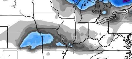
Some light snow and flurries will try to streak across the entire state before weakening.
The next system coming our way is the southern storm from Friday night into Saturday. The models continue to go back and forth on the strength and track of this, but I do expect a decent swath of winter weather across Kentucky.
The latest European Model shows this well…
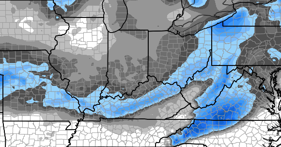
The European Ensembles show a greater shield of winter weather…
My concern continues to revolve around the possibility the models are in their window of waffle and go back toward a slightly stronger system.
The new SREF 12 hour precipitation numbers through the middle of Friday night show my concern…
That’s a lot more juice than many of the operational models are showing.
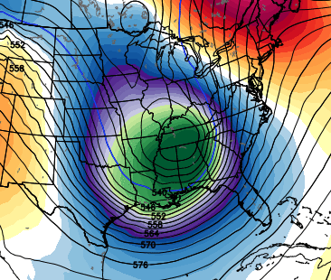
Christmas week continues to show some BIG BIG potential for cold and snow for millions of people and that includes our region. The prime time to watch will be late Tuesday into Christmas Eve. The upper levels are primed for a big system. Check out the European Ensembles Christmas Eve…
The GFS Ensembles aren’t too far behind…
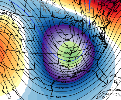 Another system will follow that up a few days after Christmas.
I said on here about a week ago that any winter weather we get before next week would be a bonus. The REAL action starts Christmas week and goes through January.
I will see you with a full update later tonight. Take care.

Thanks Chris. Looks interesting! Hope we get snow for Christmas!
Snow all around seky but none for us lol same old same old.
Welcome to the land that snow forgot! L.A. or Miami has a better chance of seeing a sizable snow than we do….
Usual supects pick up snow on ground wirh weekend snow. everyone else gets usual.
Christmas storm could be different. Everyone get in on something. Chris has been seeing something for Christmas for some time.
All I want for Christmas is SNOW!!!! Keeping my fingers crossed!!!
I am sitting in the presence of our friendly neighborhood weather dude! Do I ask for a picture with him?!
Roger will be pleased with just one BIG snow from those storms. Closer to Christmas the better! Two big events even better. Roger likes the deep stuff.
Roger on that 😉
Come on Santa Snow Train!
Chris head to Chicago and pull that low north with you. Just because you won’t be around to enjoy the snow doesn’t mean we all don’t want it. LOL Euro is out to lunch….it will come back around….just be patience. Loving the setup heading into the new year….
I noticed on the model maps that area from about Charleston/Huntington WV down towards Jackson/Hazard KY area is void of the snow track. this happens too much for it to be snow lovers bad luck. I know about the lake effect snows and how ocean water temp can cause more rain near the coast. But I have never seen an explanation for this pattern.
I live in this area. Seems like if it starts as rain cold air has really hard time making the changeover to snow. Dunno if it is the terrain or what
Mark I have seen it explained once… it has to.do with the rotation of the storms. If you notice the eastern side of the apps usually get more snow because there is usually a cold wedge pulled down from the north and the apps help hold that in place and vice versa 9 the eastern side. We get a warm wedge all the time. The storms pull up warm air from the gulf and it gets wedged in and we have to try and drop the Temps during storms that have marginal temps and it usually isn’t cold enough until the storm is over. That’s just what I am told. For us to get a really grgreat snowfall we need cold that is locked in or a storm path from the panhandle of Florida straight up through virginia!
Best explanation I have read. I was thinking along those lines. Just really depressing for snow lovers in that area. Especially when areas to the North and West get snow during a storm then after it goes by the mountains to the east gets it. This is just a dead zone for snow. Takes a very special storm to treat us like 93 or 96.
Absolutely..it’s the tradeoff we apparently getc because when there are parads of clippers cominhlg.from the northwest the east gets them and then the mountains break them up before they can get to the west of the mountains.
temps noytt going support much snow this weekend.
I m thinking we ‘ll still be waiting for the next week’s BIG ONE in April lol 🙂
Yeah, really. It’s as futile as Linus waiting for the Great Pumpkin to emerge from the shadows.
Same song, same dance. Yet another winter of “wait until next week.”
Actually, this has been the darkest, depressing and wet Decembers I can ever remember. The weather right now reminds me of winter weather in the UK.
I’m ready for spring (already) and more light, this pattern really sucks.
And my wager is still there, <10" of snow for London/Jackson for this winter.
It’s been over 20 years now that we got the blizzard of 1993, i was thirteen I remember it like it was yesterday.we have not came close to having anything anywhere near that in seky, the young generation of today has never seen a big snow and that’s a shame!
Would love to see the maps have corresponding snow amounts to go along with the pretty colors
I do remember the big blizzard in 93 I always heard that time will repeat it sealf will it happen this year a very slim chance this year