Good afternoon, gang. It’s back to normal here on KWC… that’s if there is anything “normal” about what we do around here. 🙂 It’s Christmas week and we have a big storm ready to work right on top of the bluegrass state. Can it bring us the infamous White Christmas? Not by the true definition, but some flakes should be able to fly.
Showers are rolling across the bluegrass state this afternoon as temps take off toward the low and mid 50s. The rain may be accompanied by some rumbles of thunder into tonight.
Current temperatures


The rain will increase later Tuesday as temps surge toward 60. Winds will also increase as our low pressure works closer to the region from the south. That storm will then work right on top of us from south to north on Wednesday. Rain, wind and thunder will be followed by crashing temps from west to east. The numbers may drop 30 degrees from Wednesday afternoon into Christmas Eve and Morning.
That cold air allows for a switch to snow showers and flurries…
 Winds during this time should top 30mph at times, so Santa better pack the Dramamine.
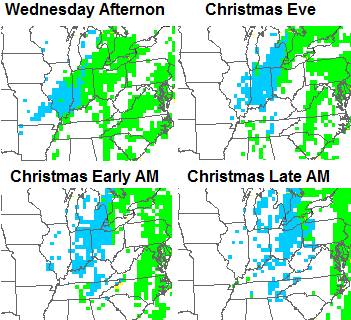
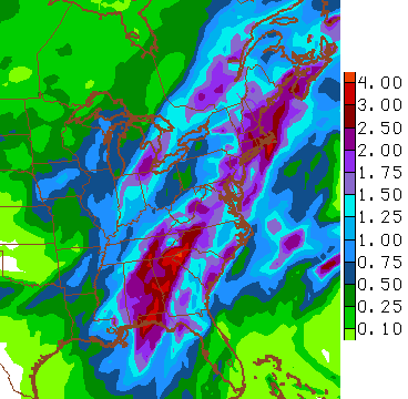
This is one heck of a holiday storm, even if it’s not going to totally “bomb” out across our region. It will impact millions of holiday travelers cross the eastern half of the country with high winds, some snow and a lot of rain. Check out how widespread these rain numbers are…
I will have another update later this evening. Merry Christmas and take care.

Oh well. Looks like all others were correct this week.. ..(not whinning, not negative…just facts)..love the dreaming…but it is what it is!
I hope tomorrow I don’t have to come on here and say I’m wrong about the Bengals winning, but I probably will
Well, I’m going for a much bolder out look.
Bengals by 10.
Widepread 1-2 inches of snow for a White Christams!
Atleast a Blue & White!
@
GO BIG BLUE!!!!!!
I believe bengals will win, but I don’t believe snow
This is just in good fun Bengalsfan,but I have been a huge Steelers fan for over 40 years and I hope we get snow,and it’s a great day to be a Wildcats fans and we beat the Bengals next week in Steel Town.
I’ll take flakes flying. It beats cold rain.
There will be cold rain 1st
Followed by dry cold
I’m getting a bit leary of the big push toward a winter pattern by the first of the year. The past two systems have busted big time from 5 days out & now we’re two consecutive posts without a mention of the big pattern change. I think the models are almost unreliable except from a short window out.
And the hope of “next weeks snow”.
Have you been outside today? I’d say warm rain first.
Warm rain then cold rain then dry air 😉
Heck, Rodger wishes this was a big snowstorm but some flying flakes and cold will make it feel a bit like Christmas.
Ten years ago was the BIG THUMPER SNOW/NEAR BLIZZARD in parts of western Kentucky. 15-20″ for much of Rodger’s area with his driveway drifted 3-4 feet deep. Got down to -10 below on Christmas Eve night. He’ll never forget it that likely once-in-a-lifetime event for his area.
Read about it here: http://www.crh.noaa.gov/pah/storm/christmas04/main.php
watch John Bels.
forecast last night.
he said next week highs will be in the twenties
Imo that will allow reinforcing clipper chances.
John Belski
Great Louisville Forecaster
Boo hiss! Still hoping for a Christmas miracle! At least it won’t be 80*. That’s so NOT festive!
Chris, please ask Mother Nature and Santa Claus to bring us some snow for Christmas! We need to get a good snow on the ground around here! Santa must be getting tired of using the mud sleds on his sleigh! 😉 Welcome home, and thanks for the update!
Chris looks like your cold January is in trouble…models are starting to take it away . Just like the last two winter storms that have turned into a epic fail. Although the pattern screams harsh winter… I think the MJO and solar activity is leading the way. Unless we get get a sudden warming event to bring arctic air down and or blocking starts to develop this winter is in trouble. Sure we will get a period of cold and maybe snow or two but nothing like most of the Mets thought was coming. You got to be scratching your head at the cold and snow always being 10 days out.
I know I’m in the minority here when I say I’d take 50s all winter. It looks like we can count on a Polar Express coming late next week though. If you didn’t winterize in November, the time to do it is now.
We may be the minority Jamie but I’m with you 100%. I will take 50’s as well. If there’s gonna be no sizable snows, cold temps are wasted and quite frankly pretty miserable when there’s no accompanying eye candy.
Jamie , better be careful on here or the snow lovers will attack you. I’ve been attack in prior years for stating that I didn’t like snow or want any snow. Some of the attacks are brutal too..lol
Actually,everyone seems to be playing nice this year and not doing a ton of back butting. Snow or no snow,CB is the man.
I so agree Chris is the best at what he does I just so ready for some cold and snow