Good afternoon, all. I have no changes to the wild ride ahead of us for Christmas Eve into Christmas Morning as a strong system rolls across the region. Heavy rain, high winds, thunder, snowflakes and a HUGE temp drop are all on the way.
Check out the drop…
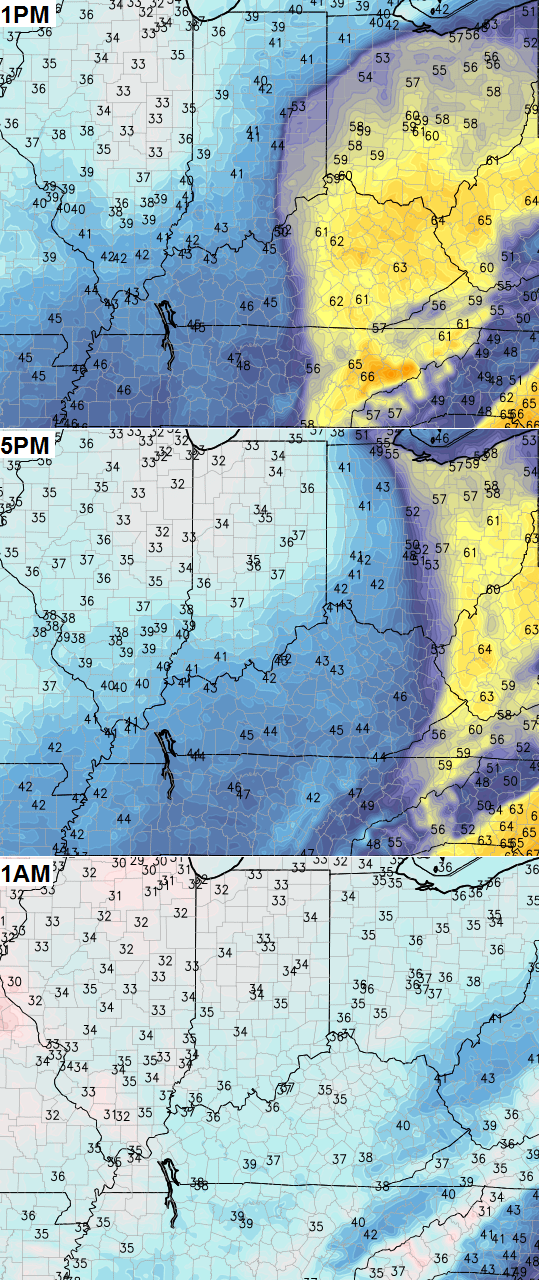
Winds of 40mph or greater will be possible as the cold air wraps in. Snow showers and flurries will then fire up later Christmas Eve into Christmas Morning.
In the overall scheme of things, the models from a week out did a very good job in forecasting this storm. They were a little too strong with the storm and a bit too far east with the track… but it was a week away! I keep telling you guys to never take any one run of any one model as the gospel. Many of you get that, but it’s clear there are some who have no idea what a weather blog is about. Those folks should probably stick to the awful weather apps or listening to other folks who only report the weather instead of trying to forecast it. 😉
Our next system rolls in this weekend with rain on Saturday with rain or snow Sunday. This sets the stage for arctic air to arrive right on cue as we close out 2014…
I will have another update later today. Merry Christmas and take care.

Well we have though March, and maybe into early / mid April to get some more snow, so no reason at all to freak out. This past spring we had several inches of snow in mid April in Northern Kentucky to top off our 50″ plus inches of snow winter last year.
Reminding people of how much ridiculous snow you all received last year may not be the best way to accomplish your goal.
We did not get much in Richmond last winter, if that is what you mean by ridiculous 😉
Not too disappointed as I a getting exactly what I expected. Heavy rain and a few left over flakes. No biggie.
Thanks Chris! Winter will deliver…patience!
Thanks chris we all or most of us know that you are the best I know sometimes I get my hopes up for snow and yes I get a little cranky sometimes but I know you are the best and I love this blog you know your stuff I trust you and you only just do something get us some snow just kidding I know we will get our cold and snow now lets just in joy the christmas holiday and just be glad we can happy holidays to all of you stay safe
Thank you for all the hours you put in for the weather lovers! I really appreciate all you do and enjoy reading your blog! I’m a follow from wsaz viewing area…, and have followed you. Merry Christmas and a snowy New Year! (Fingers crossed.. I’m a teacher in Ohio and I will need my 5 snow days) lol
I think I have hit upon a solution. Ignore forecasts, expect rain, be pleasantly surprised if it snows.
Best solution is to realize that these models are not forecasts. Do not expect the weather tomorrow to be anything other than what it is. At least that works for me. About the only time I take it serious is when an actual forecast is made. And for 2 days at the most. And the I still expect the weather to be weather and the forecast will not be absolutely perfect.
Now that this week’s Winterstorm/artic air have gone down in flames, it’s time to start pointing toward the weekend snow/artic outbreak. Until we get to Friday and it turns out to be rain with 40 degree highs.
Airing some Grievances on this day of Festivus Chris? Can’t blame you really lol!
LOL… yep. People who have been here for the long haul know when I make a forecast… I make my own map and don’t just show what models are saying.
I was hoping for an early start to winter, but it doesn’t look to be happening. I know winter technically has just started but late November and December can throw out a suprise snow every once in a while. Very little snow has fallen in the southern part of the state with none of it staying on the ground. Maybe January can overachieve.
My guess is most people who check this site do not review each model run of the Euro, GFS, Canadian, etc. Therefore the one posted appears to be the one given the most credit.
I enjoy reading the blog very much, but I think back to a couple weeks ago how it was suggested last Wed/Thur may be some type of storm, then last weekend was going to be a storm, and how confident we were looking at a White Christmas. Now, two days before Christmas, it is almost 60 degrees with no storm developing and hardly a mention of the unseasonable warmth.
It just seems the most radical model solution is posted, no actual forecast is made aside from a suggestion of future possibility, and then the model is blamed for disappointment.
Then find another blog. Nothing you said is true at all. NOTHING
“It just seems the most radical model solution is posted, no actual forecast is made aside from a suggestion of future possibility, and then the model is blamed for disappointment.”
Well, unless Chris puts out a forecast it seems he is just giving insights to what the models are showing. I find it amazing when some complain at Chris about a missed storm a model was showing. Even when he has previously pointed out that even he was not buying what the model was showing.
And after the temperatures kept coming in lower most of the time we were due for a warm period. Seems that happens right before cold spells in the winter for some reason. And I have seen at least 2 extended forecasts calling for low 30’s and upper 20’s for highs. Seems like at least some are seeing the cold coming for the very end of December and January. Guess we will see if the weather plays along.
The lightning map is quite active in much of Tennessee and as far north as near Ashland KY. It’s lighting up like……..well, a Christmas tree 🙂 . A few people are even wearing short pants.
We have to remind ourselves that it’s December, not April.
I always come here to get s idea what weather will be. Ive followed chris’ blog since his wkyt blog years ago . Hes one of the best. He sees what could happen in weather in the upcoming weeks. Models throes a curve in his thinking sometimes. For last month he knew something would be going on this week. We got warm , rain and wind.
Last year he warmed us of zero degree weather coming , and we got it. He has said january could get colder then his thinking. The cold I can believe . But I see bubbas 33/32 rule come to play . No mosture for snow during cold spell.
chris’ extreme prediction of ky getting a double digit snowfall im guessing comes late January for lexington northward towards louisville. Eastern/southern ky will get rain or ice or mix. Have bet on trend. Some clipper systems in feb will give southern ky maybe inch or msybe 2.
1. This is a Kentucky weather blog. Readers and responses are from all over, including Kentucky ex pats who still follow from overseas.
2. The point of this blog is to discuss weather, not to get your weather forecast. It’s about possibilities, probabilities, and in Bubba’s case, pipe dreams. 🙂
3. I’ve been around for years but rarely comment. The naysayers do annoy me, though. Usually I just skip over them. I miss the days when the amateur mets contributed their thoughts and the reasoning behind them. I can only guess they must have been silenced by all the negativity last year.
4. Expressing disappointment is one thing. Comments that appear to hold CB accountable for the weather are absurd. How in the heck could CB be responsible for the weather? He’s a man trying to interpret computer data. He doesn’t make the data, sample the air that produces the data, or put the data into a computer. Until I see an ALERT, I know the discussion is theoretical. That’s a lesson to learn if you’re going to be a regular. At no time over the past week did the word ALERT make it into any discussion CB posted.
5. Thanks, CB, for the time you put into the blog. I hope you had a great trip to Chicago and have a Happy Christmas!
6. Rant over.
Hope everyone has a safe and enjoyable holiday.
I also hope Chris can give us some insights and models on the possibilities for early January and some extended look as well up through the end of February. I know it might not happen, such is the weather, but I would find it most interesting.
Really hoping no school is missed this year and all the snow happens on weekends. That way they get out earlier this year. My oldest is graduating and heading to college. Would be nice to have a little extra time before the fall semester starts.
I enjoy your blog on a daily basis. You and Brian goode are the 2 best meteorologists anywhere. I live in southern indiana and follow the weather intently each day. Like other big weather enthusiasts I think you do a great job keeping us abreast of our changing weather. Thank u for your hard work. Everyone have a Merry christmas!