Good Saturday to one and all. Rain is pushing back into the bluegrass state today and it will stick around through the rest of the weekend. Things will actually get pretty darn ugly before all is said and done. This pattern is on the leading edge of arctic air that is finally returning to America.
Clouds will continue to thicken up early today as rain breaks out in the west. That rain will then roll toward the east this afternoon and evening. Ahead of the drops, a mix of sun and clouds will allow temps to shoot well into the mid and upper 50s.

Current temperatures

The rain will increase tonight into Sunday as another wave of low pressure works across the region. Low clouds and fog will also be noted as temps slowly drop into the upper 30s and low 40s from northwest to southeast later Sunday.
Rainfall totals through Sunday night may reach 1″ in many areas. Here’s the NAM…

That same model run tries to develop another wave of low pressure Monday night into Tuesday morning as the colder air continues to filter in…

If that wave is real, light rain and light snow would be possible during that time. Notice the moisture well back into the cold air in the plains states… that could be a flurry maker later Tuesday around here. That’s being pushed by a true arctic high pressure moving into the heart of the country. That’s likely to slam a lot of the forecast numbers from the models.
The Canadian Model continues to bring the coldest air for the final day of 2014…
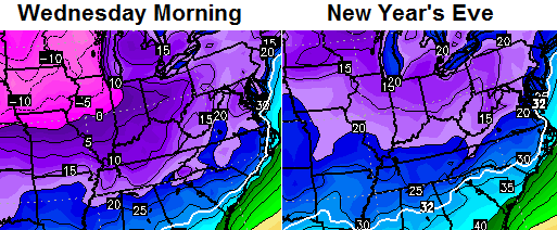
That’s a COLD look!
With the infusion of arctic air finally back across North America, we have to watch to see what kind of interaction it can have with the southern branch of the jet stream. This continues to be very active and will try to throw a couple of systems our way late in the week. The new version of the GFS continues to like chance for winter weather…
That model continues to spit the energy out at us in pieces which leads to the winter potential. If all that energy decides to come out at once… it would lead to a much bigger storm that would likely track much farther to the north and bring more rain into the mix. As always, we shall see.
I will have updates later today. Make it a good one and take care.

Translation……if it’s snow it will be very little, if it’s cold rain it’ll be a lot. I’m ready to track severe weather and chase turkeys bring on spring!!!
Thanks Chris, As always you are right on top of things. Looks like a wet Saturday earlier than thought from the looks of the radar this morning. Need it to hold off for a little longer to take care of an errand though. Surely the pot will come to a boil at some point this winter for a good snow. I’m not greedy. One big one would be very nice! As you said, we will see. Have a great Saturday everyone and GO CATS!!!
I don’t see any true artic air happening and locking in anytime soon. Colder temps yeah but typical for this time of year. Upper air pattern doesn’t support any real arctic air. Not going to happen this week.
Must admit so far the cold air/snow chances seem to slip out further each week. Almost like in order to be excited for snow potential, a person would have to have a short range memory that resets each week 🙂
No doubt it will get cold, but dang it- it IS winter ya’ know.
AS ALWAYS WE SHALL SEE….it rain!
I guess it could snow “next week”…kinda like the Cards could beat the Cats today…BUT THAT’S NOT GOING TO HAPPEN!!!!
There are two teams at the moment that could trip the Cats. One is Duke (if 3 making their threes) and the other is the Cards. Could be a battle today 🙂
Yeah. And it Could Trip up and snow here in Richmond
The Cards have a better chance than that actually happening beyond an inch or two 😉
As said- Battle! Cards can win and are in position to make it possible- especially with Stein having three fouls.
Very possible… unlike a snow above three inches in Richmond 😉
Possible, yes, but reality..NO..just like snow in the near future
It will be tough to beat UK. Go Cards!
Thanks for all the work you do on here, Chris. I appreciate the actual forecasting you do and understand that sometimes it doesn’t pan out.
It’s early yet and I believe we’ll get our COLD and SNOW.
Go Cats!!!
Ok? Hmm…just like our weather, im drawing a blank…lol
Our winter, much like the UK-UL basketball game, has been deemed unimportant and relegated to ESPN2 by Mother Nature.
Let’s hope things improve and we don’t end up on “The Ocho”.
Hopefully a preview of things to come..Cats and Cards in the title game come march..Oh by the way …I will whisper this softly..Euro had a decent snow for Jan. 4th ..Only 8 days out..Yay…
The 12z EURO doesn’t have it. It’s been all over the place on specifics from run to run. It’s been consistent with the overall pattern setting up, though.
It seems the only snow we get is produced by the models at least 5 days in advance. If I could only live 5 days into the future it would be white at my house. I have no confidence in any of the models right now. I thought the Euro was winning until it forecasted big snows for us the week before Christmas…. 5 days in advance. Then that storm softened and went south. I want snow, quick. LOL. No more patience left.
The setup going into January is looking more and more like 1978. I know we will be on the boarder of many of the storms to come, but I would much rather have a chance than cold and dry…..
THINK SNOW!!!
I like your thinking, sir!
The coldest temp in the seven day forecast for the Lake Cumberland Area is 22. Which isn’t very articy, any chance the models are not only busting on snow from a week out but maybe temps too?
any model a week out is a bust …it can put a storm of some sort in the right time zone but cant tell ya where ….its just a guess when someone tries to pinpoint a storm 7 days away this year ..just not gonna happen ….these models are having trouble 3-4 days out honestly…..